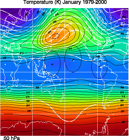
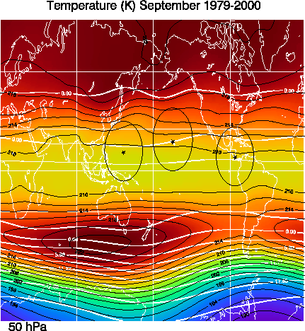
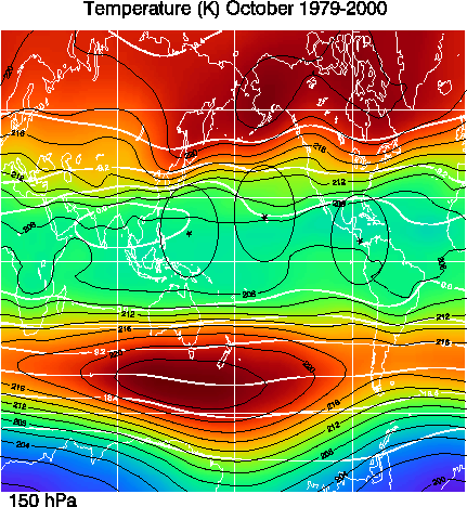
Drs. Paul A. Newman (NASA GSFC) and Darryn Waugh (Johns Hopkins) have put together this climatology of meteorological variables, water vapor, and outgoing longwave radiation (OLR) to assist in the development of a tropical upper tropospheric and lower stratospheric mission. In particular, we wished to document the regions of the tropics as partitioned by the subtropical jets (via the zonal wind or the total wind), the regions of cold temperatures, and the regions of upwelling. In addition, MLS and HALOE water provide information on water minima and maxima, while the OLR provides information on the ITCZ location.
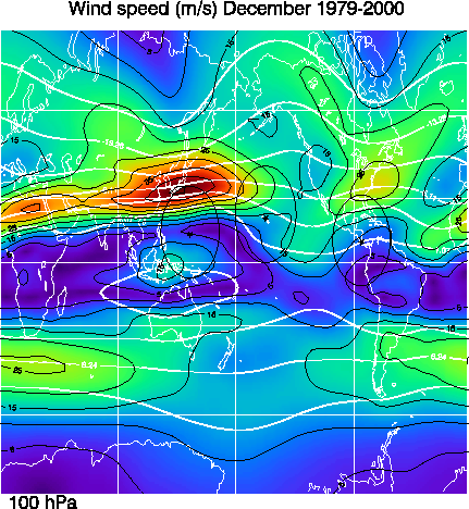
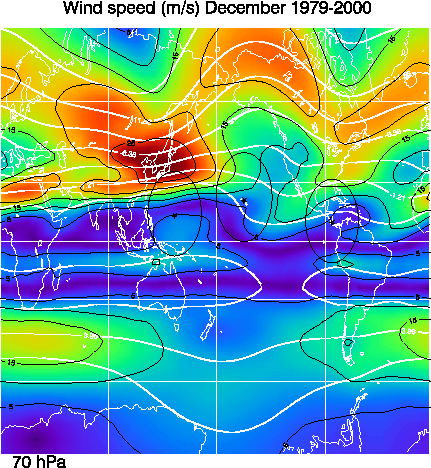
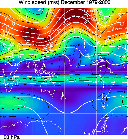
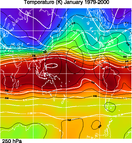
The plots have been standardized to Mercator projections centered on the equatorial dateline (0N and 180 E). Three basing sites are also indicated: Guam (13.5 N, 145 E), Honolulu (21.3 N, 157.4 W), and San Jose, Costa Rica (10 N, 84.2 E). A circle with a 2400 km radius is drawn around each of these sites to provide a maximum sampling radius for a typical 8-hour ER-2 flight.
The met data used herein are derived from the NCEP/NCAR reanalysis fields. NCEP and NCAR cooperated to produce a 40-year record of global analyses of atmospheric fields in support of the needs of the research and climate monitoring communities. This effort involved the recovery of land surface, ship, rawinsonde, pibal, aircraft, satellite and other data, quality controlling and assimilating those data with a data assimilation system which is kept unchanged over the reanalysis period 1957 through 1999. This eliminated perceived climate jumps associated with changes in the data assimilation system. Further details can be found at the NCEP/NCAR CDAS/Reanalysis Project homepage.
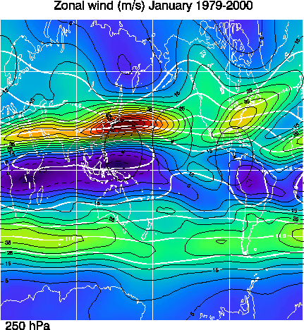
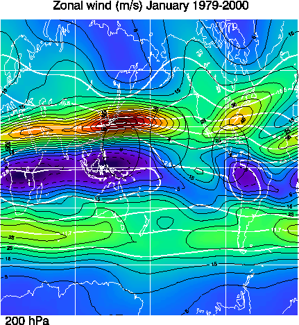
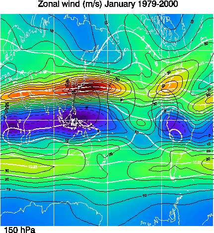
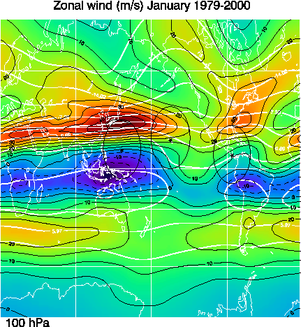
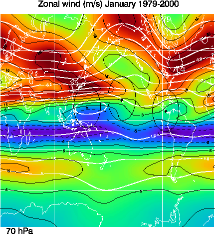
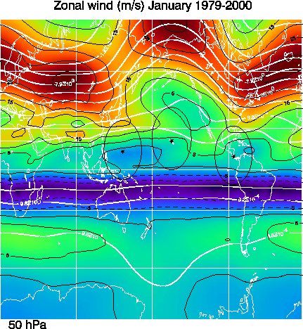
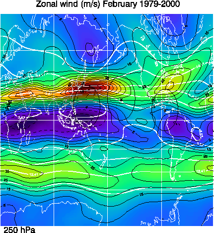
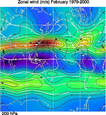
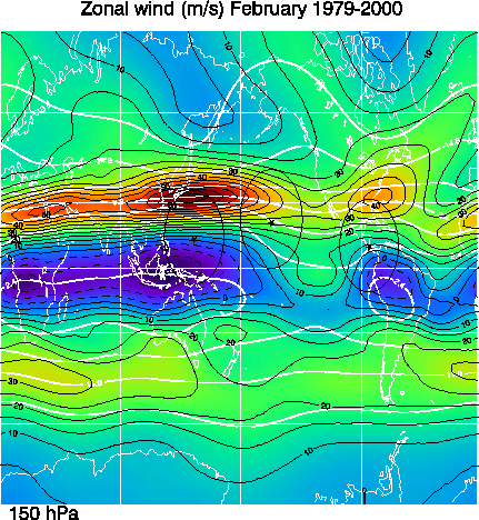
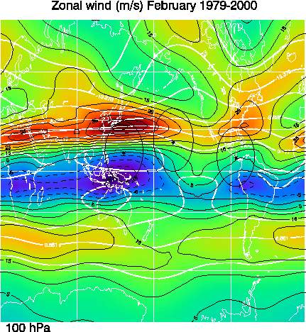
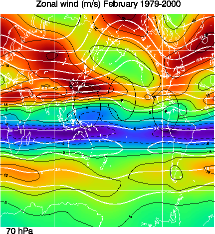
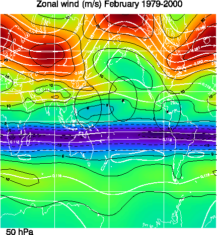
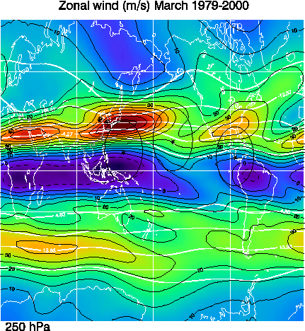
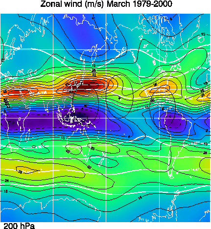
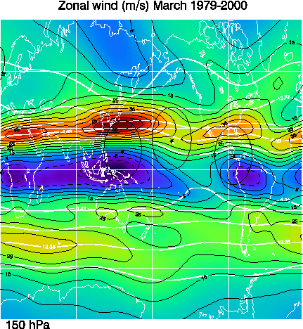
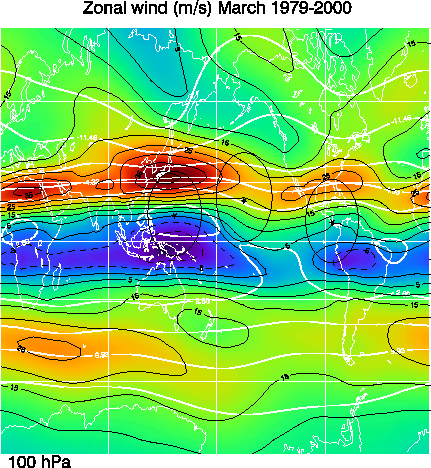
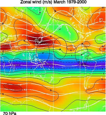
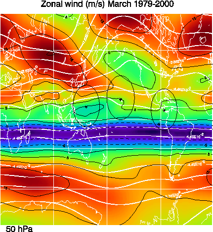
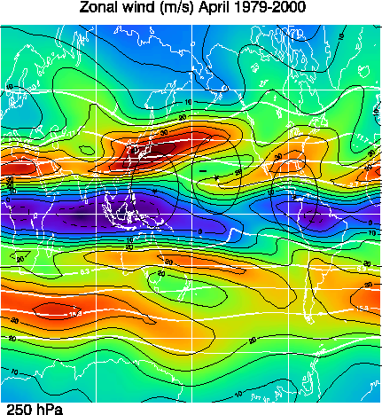
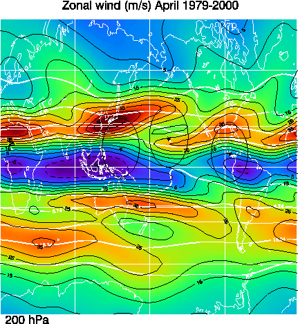
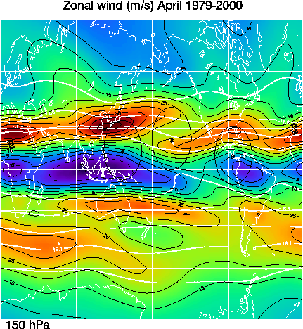
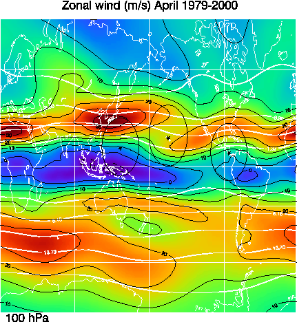
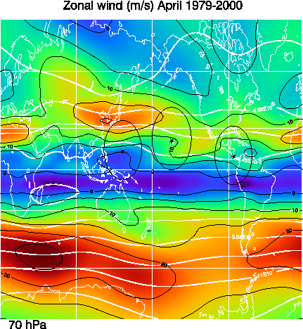
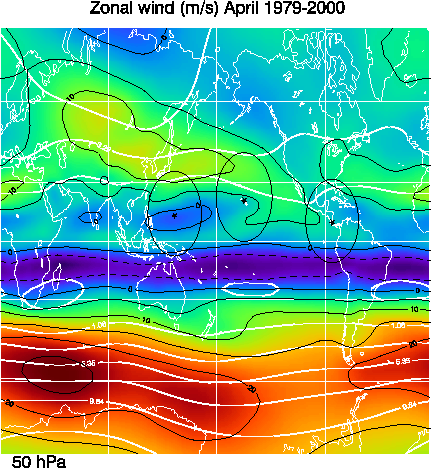
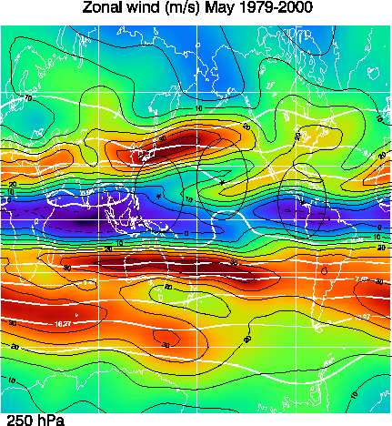
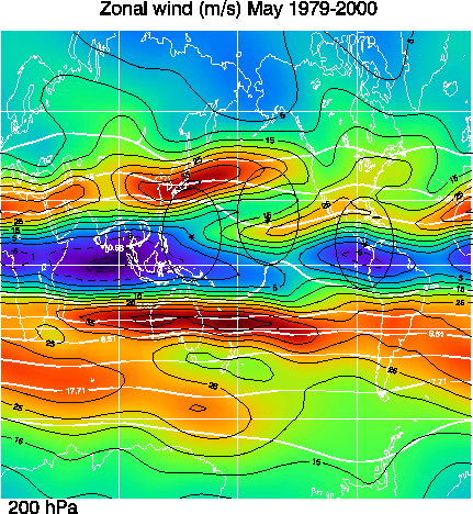
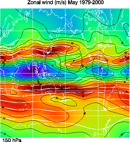
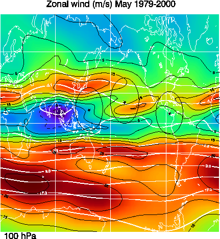
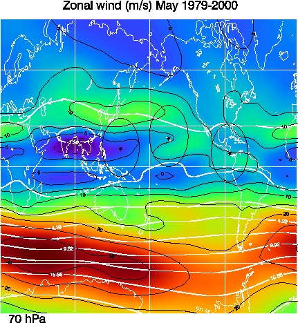
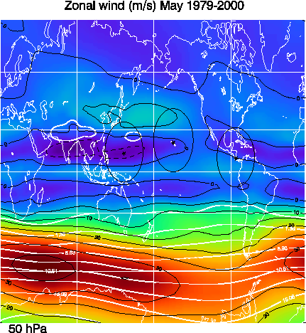
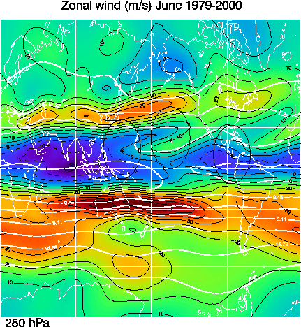
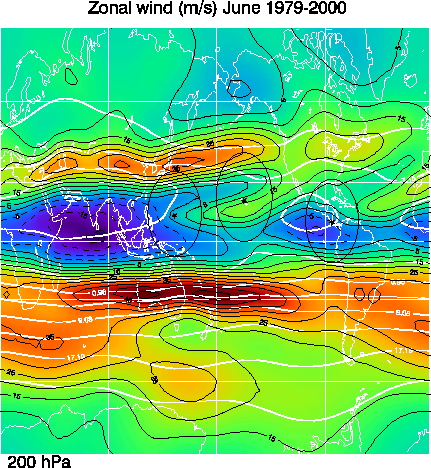
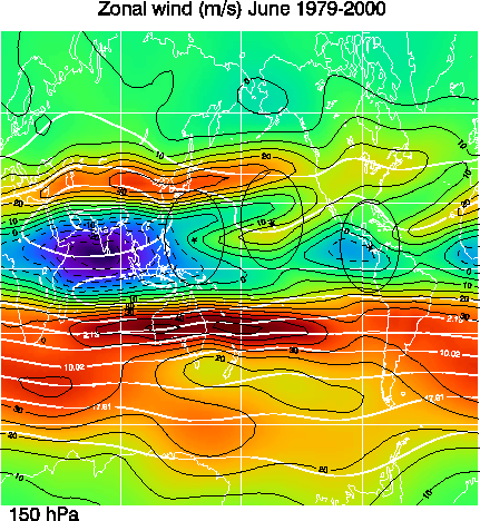
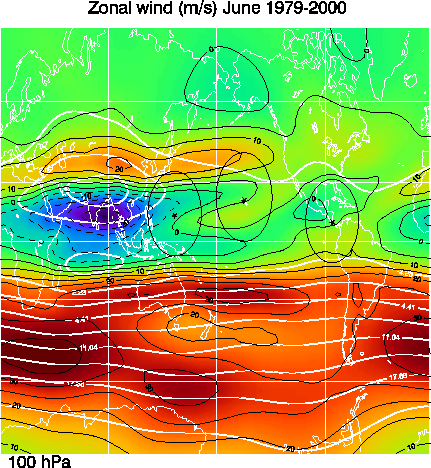
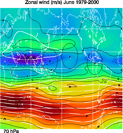
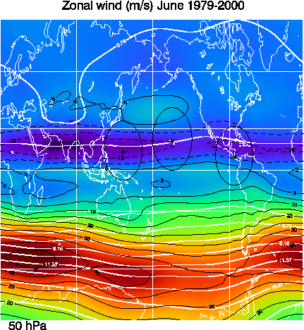
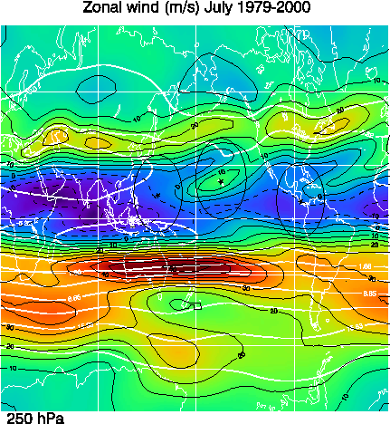
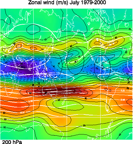
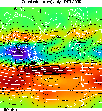
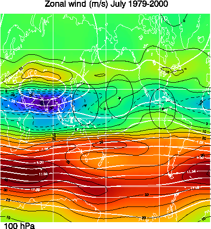
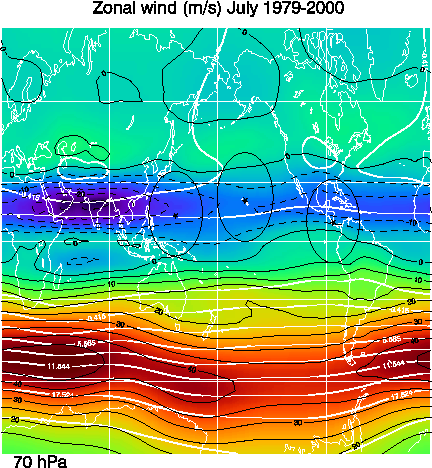
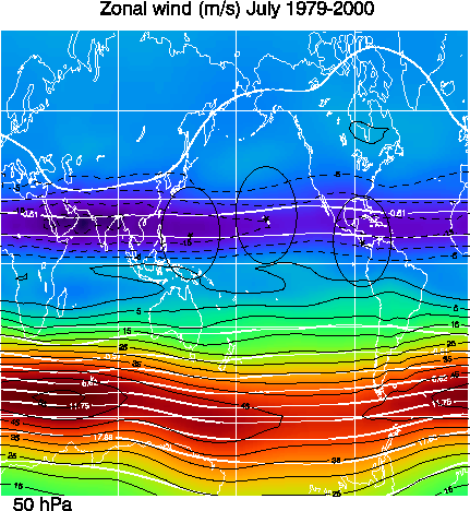
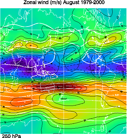
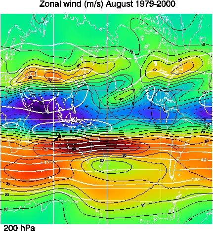
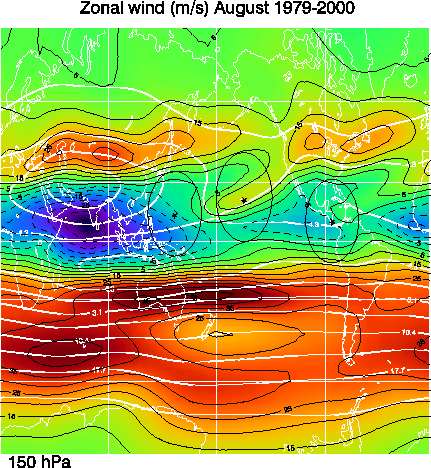
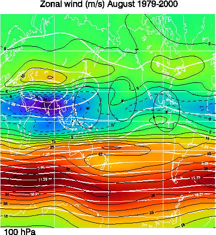
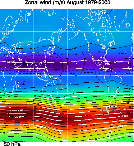
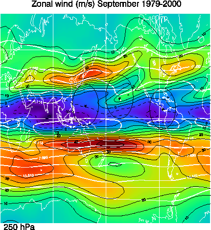
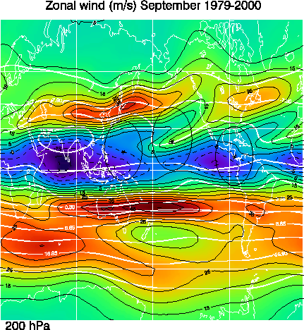
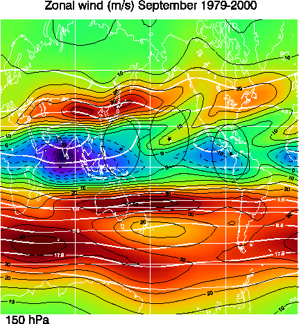
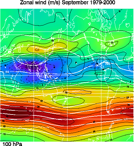
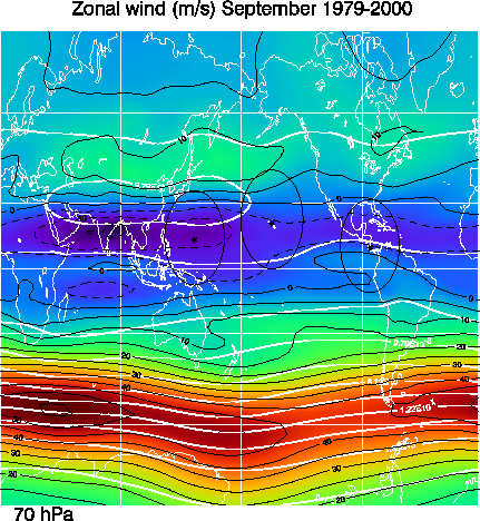
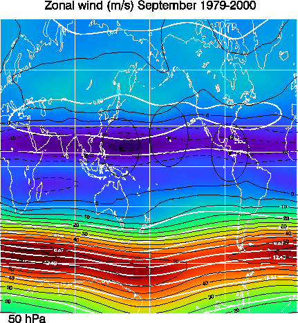
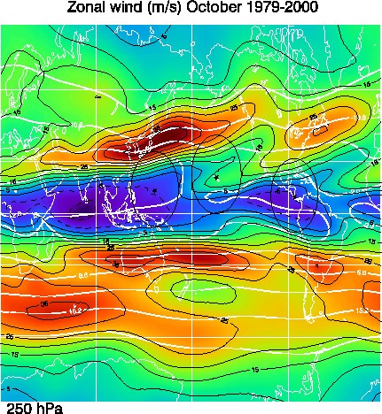
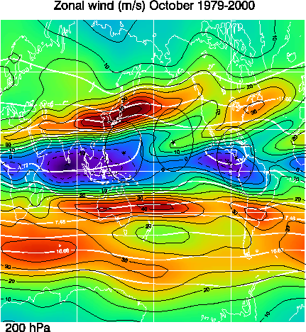
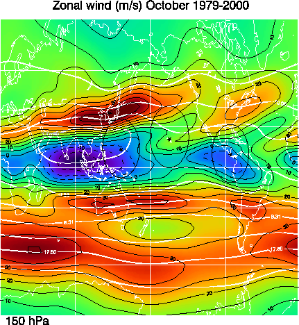
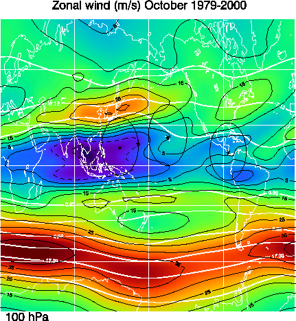
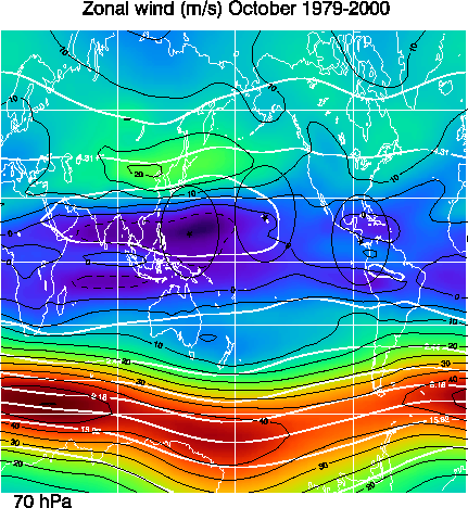
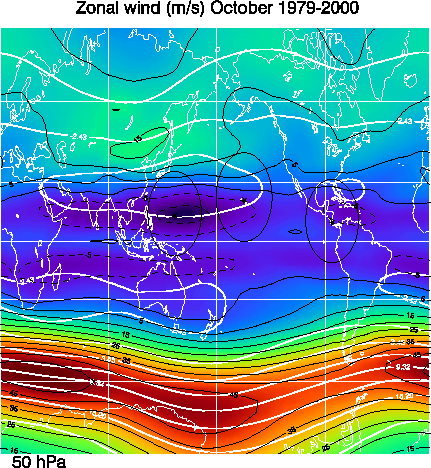
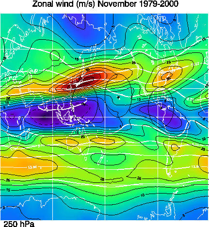
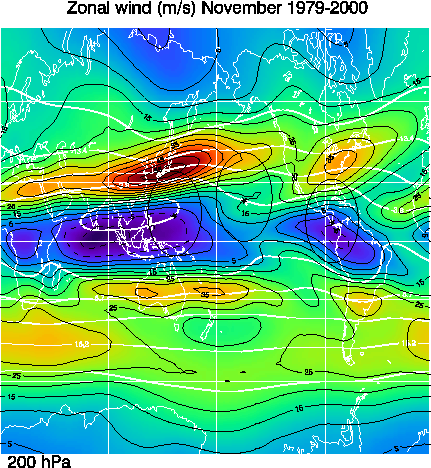
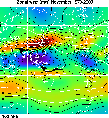
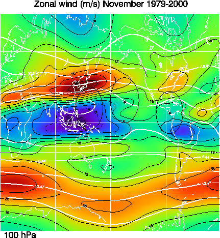
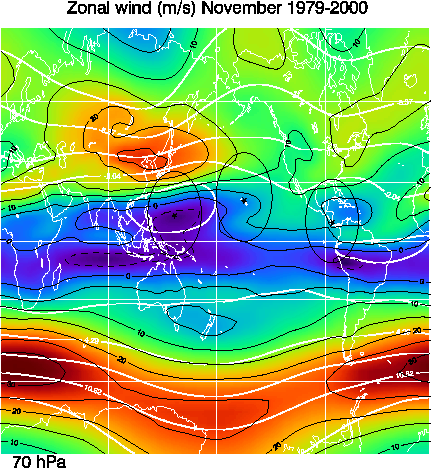
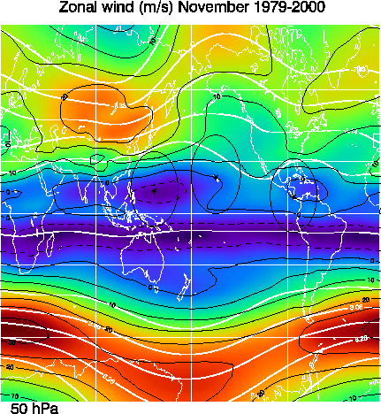
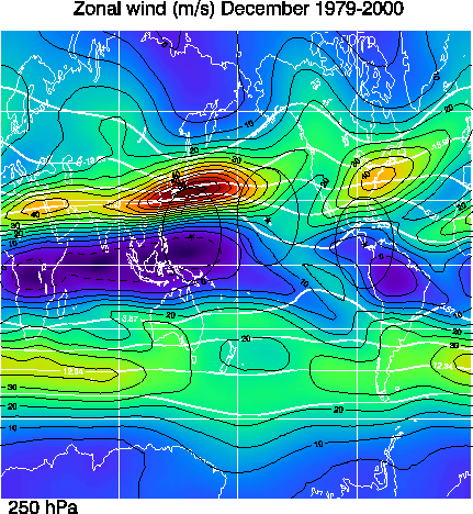
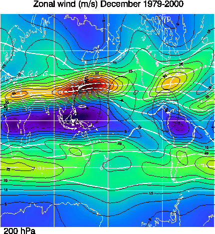
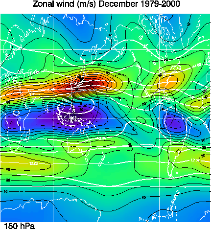
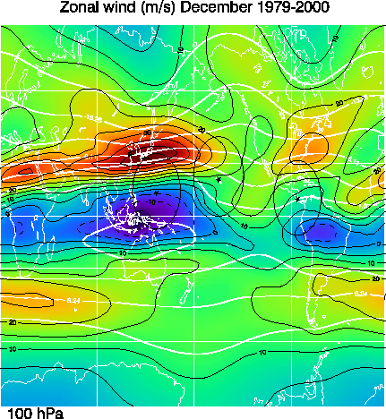
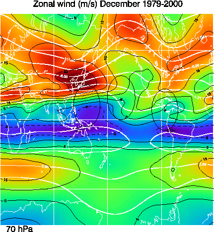
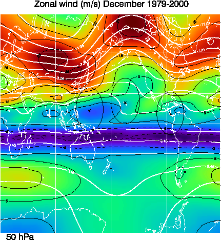
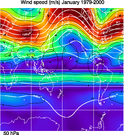
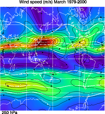
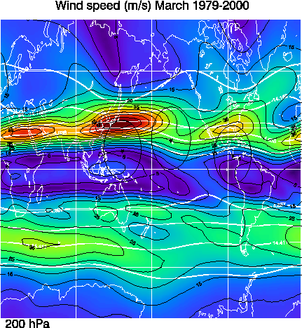
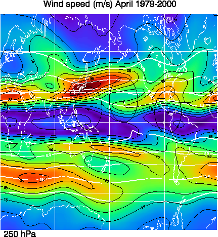
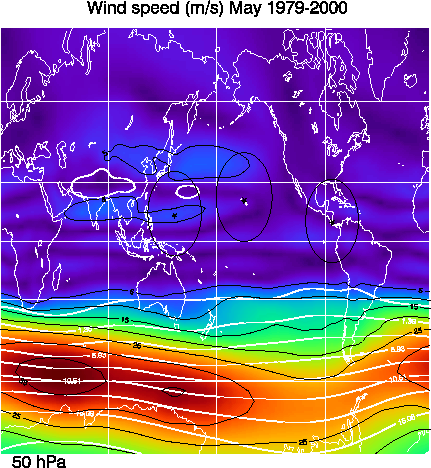
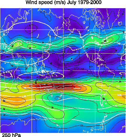
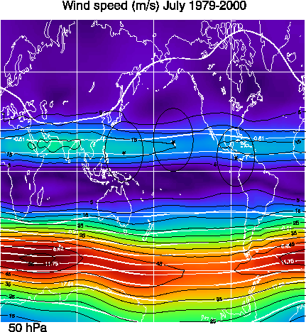
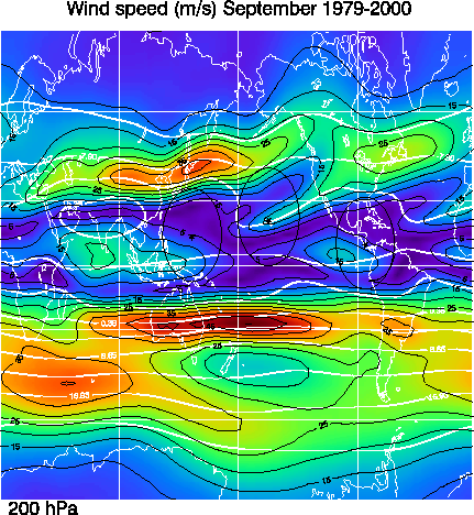
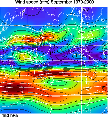
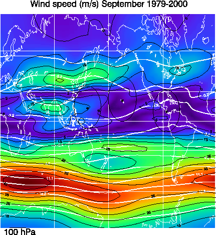
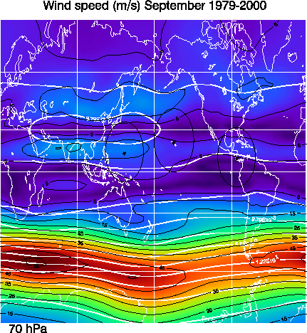
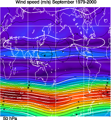
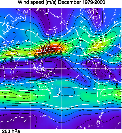
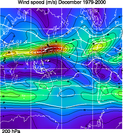
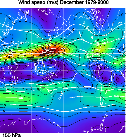
These zonal wind averages are derived from the NCEP/NCAR reanalysis data from 1979-2000. Contours are indicated for every 5 m/s while their is a color change for every 2.5 m/s. Dashed line indicate easterly winds. The thick solid white lines are the stream lines derived from the zonal and meridional wind averages. The stream line values have been normalized by dividing by the Earth's radius.
January 250 MB 200 MB 150 MB 100 MB 70 MB 50 MB
February 250 MB 200 MB 150 MB 100 MB 70 MB 50 MB
March 250 MB 200 MB 150 MB 100 MB 70 MB 50 MB
April 250 MB 200 MB 150 MB 100 MB 70 MB 50 MB
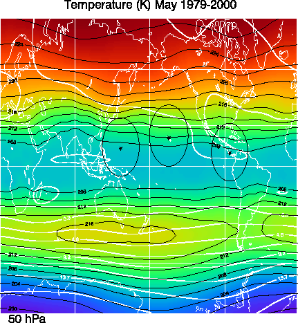
May 250 MB 200 MB 150 MB 100 MB 70 MB 50 MB
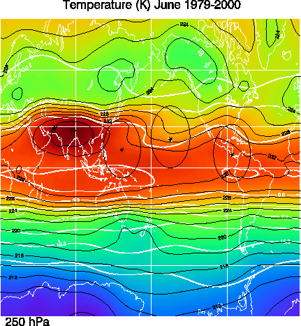
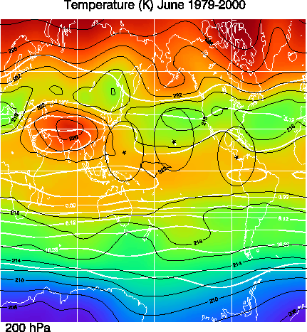
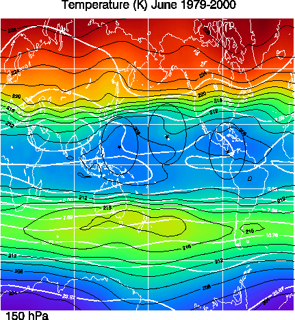
June 250 MB 200 MB 150 MB 100 MB 70 MB 50 MB
July 250 MB 200 MB 150 MB 100 MB 70 MB 50 MB
August 250 MB 200 MB 150 MB 100 MB 70 MB 50 MB
September 250 MB 200 MB 150 MB 100 MB 70 MB 50 MB
October 250 MB 200 MB 150 MB 100 MB 70 MB 50 MB
November 250 MB 200 MB 150 MB 100 MB 70 MB 50 MB
December 250 MB 200 MB 150 MB 100 MB 70 MB 50 MB
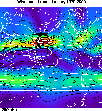
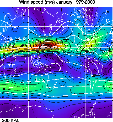
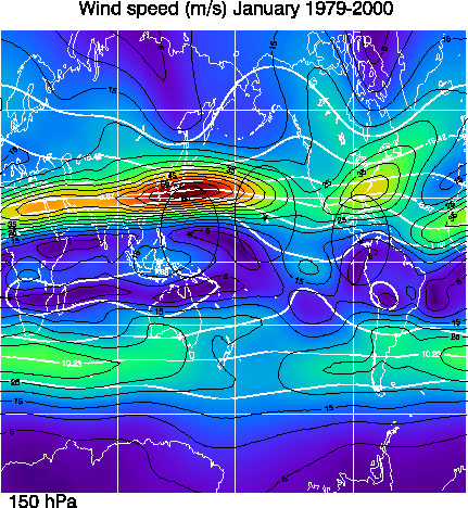
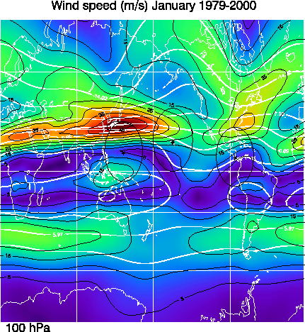
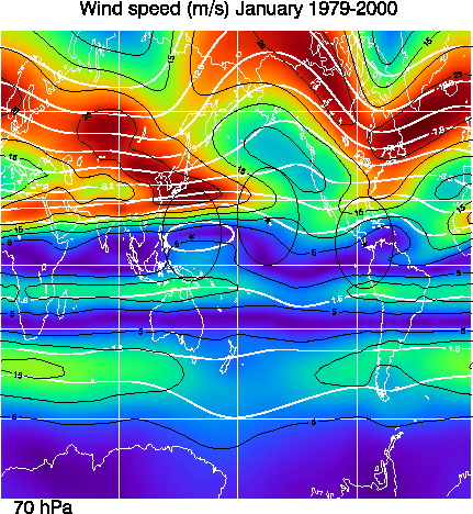
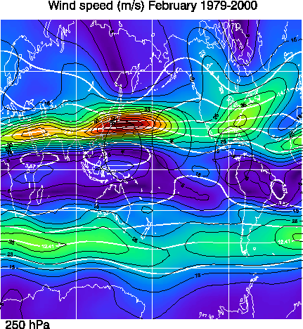
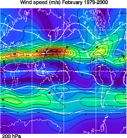
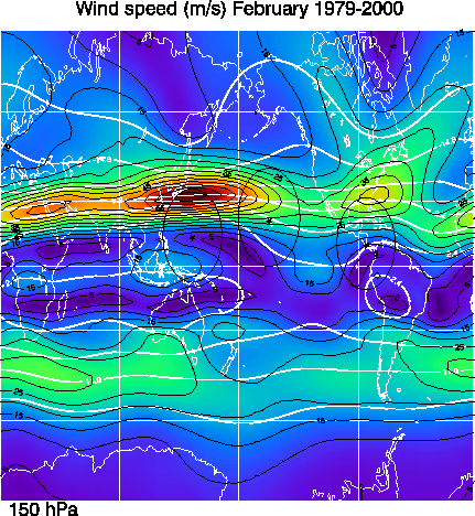
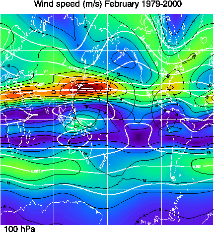
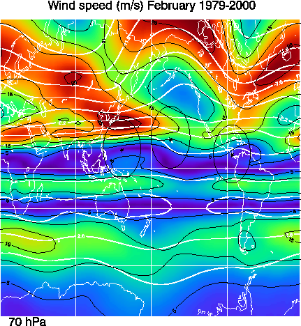
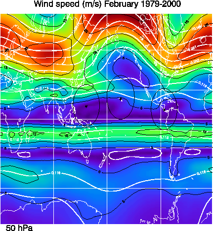
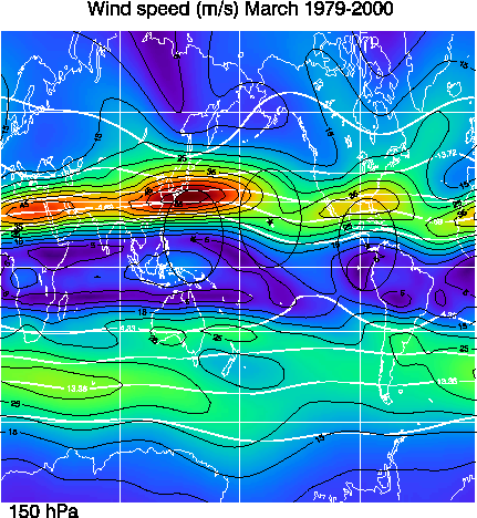
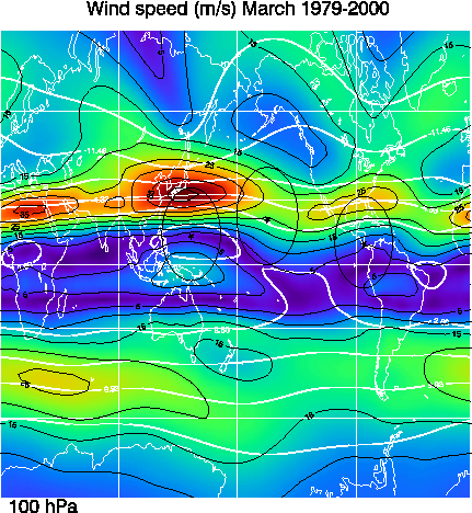
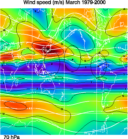
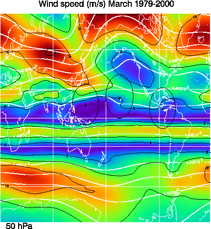
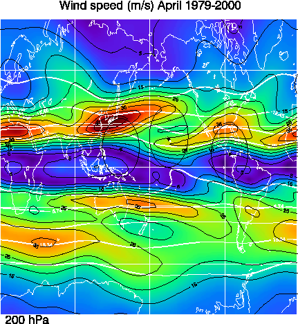
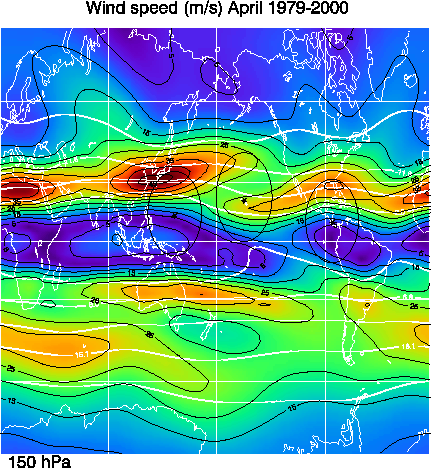
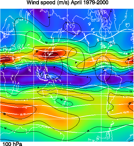
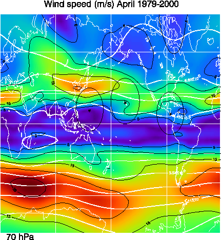
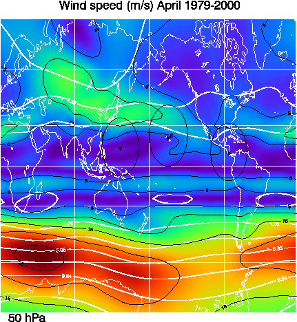
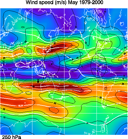
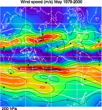
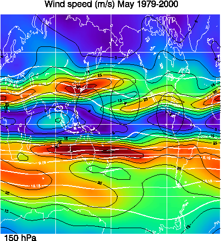
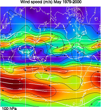
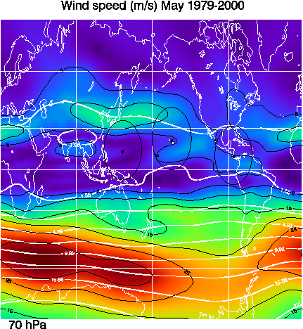
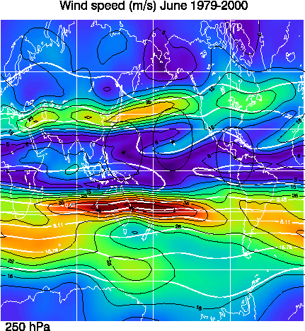
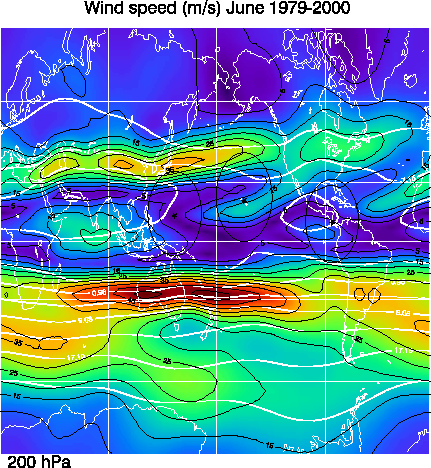
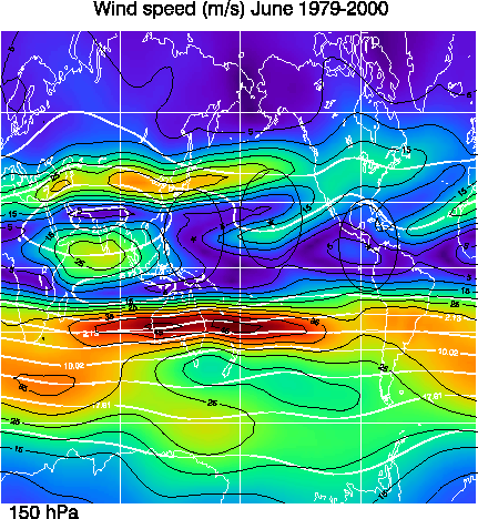
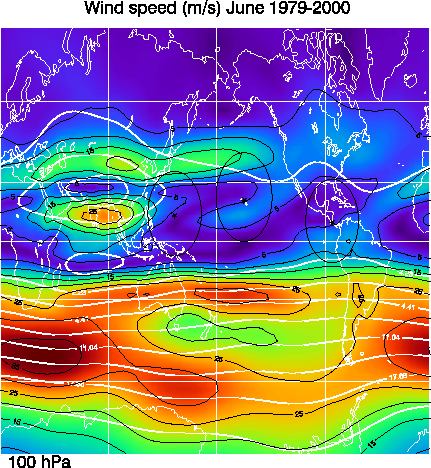
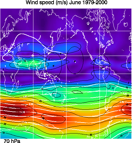
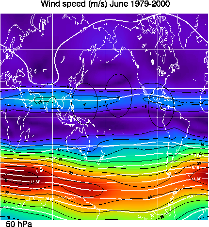
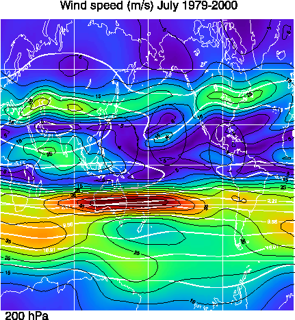
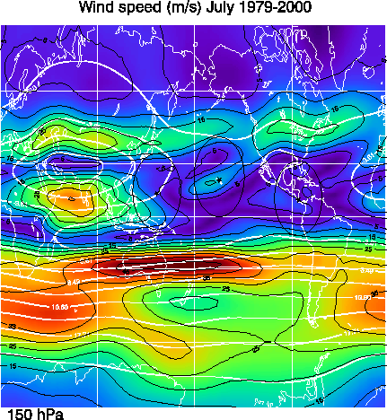
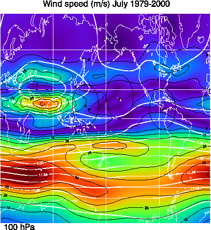
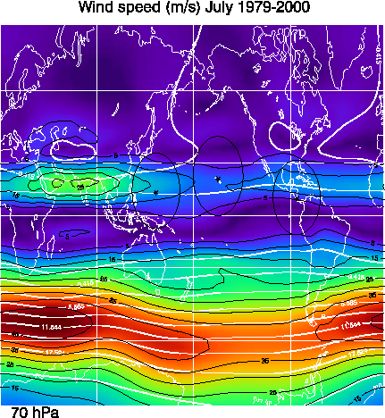
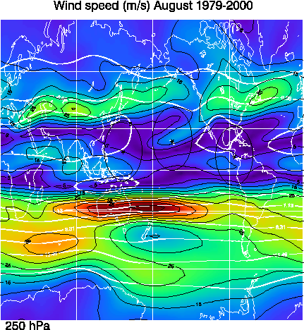
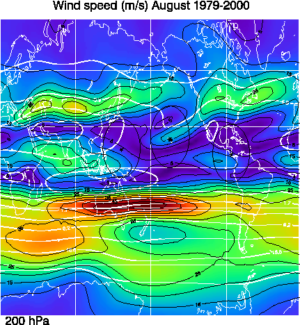
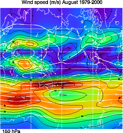
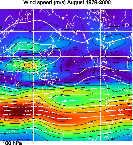
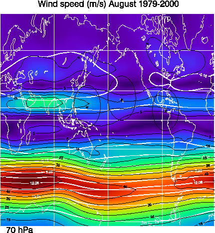
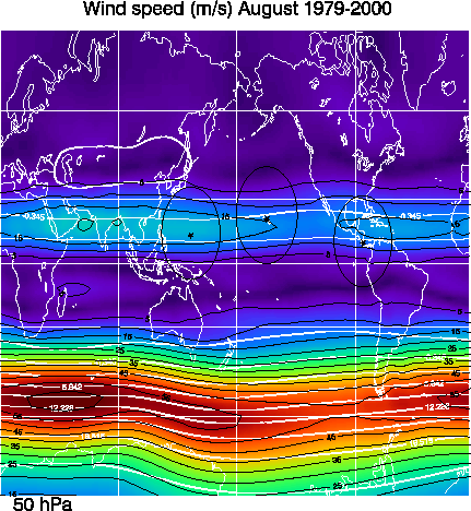
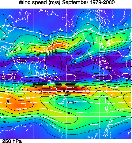
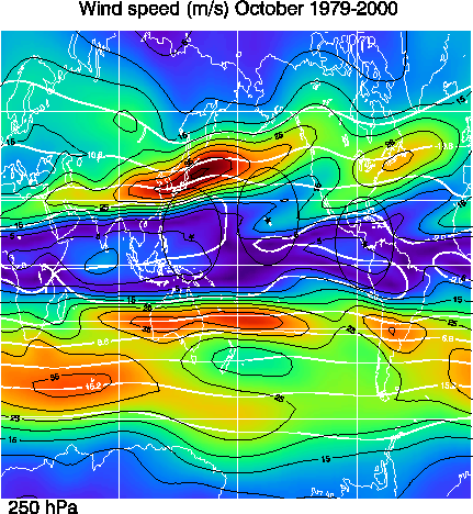
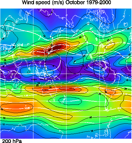
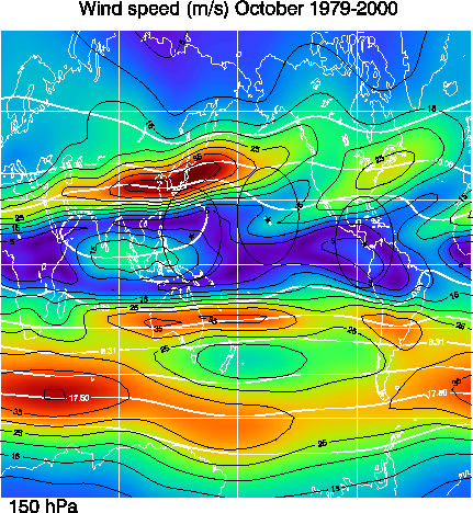
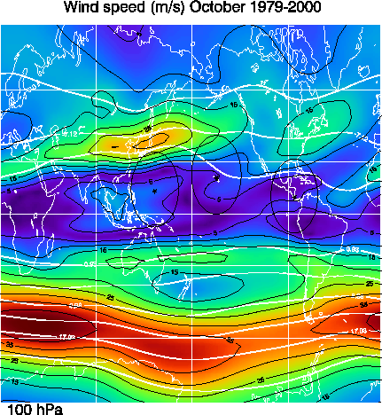
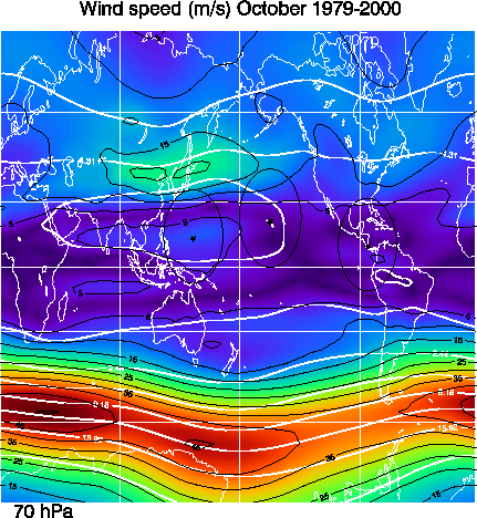
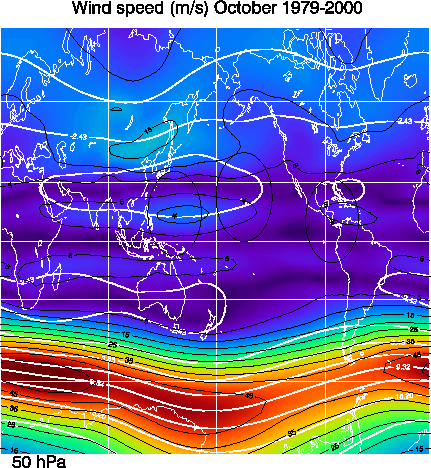
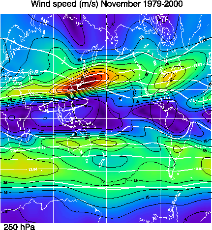
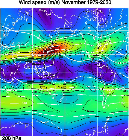
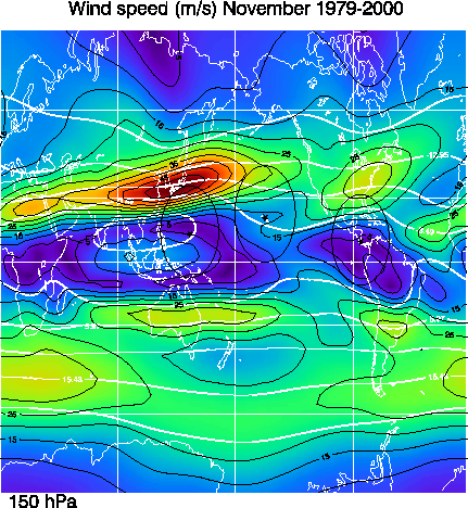
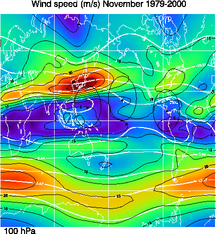
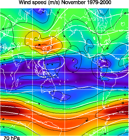
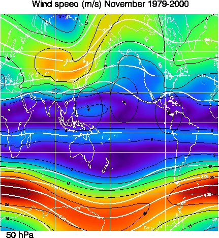
These total wind averages are derived from the NCEP/NCAR reanalysis data from 1979-2000. The total wind is derived by averaging the zonal and meridional winds for the 22 year period, and then Utotal = sqrt(u^2+v^2). Contours are indicated for every 5 m/s while their is a color change for every 2.5 m/s. The thick solid white lines are the stream lines derived from the zonal and meridional wind averages. The stream line values have been normalized by dividing by the Earth's radius.
January 250 MB 200 MB 150 MB 100 MB 70 MB 50 MB
February 250 MB 200 MB 150 MB 100 MB 70 MB 50 MB
March 250 MB 200 MB 150 MB 100 MB 70 MB 50 MB
April 250 MB 200 MB 150 MB 100 MB 70 MB 50 MB
May 250 MB 200 MB 150 MB 100 MB 70 MB 50 MB
June 250 MB 200 MB 150 MB 100 MB 70 MB 50 MB
July 250 MB 200 MB 150 MB 100 MB 70 MB 50 MB
August 250 MB 200 MB 150 MB 100 MB 70 MB 50 MB
September 250 MB 200 MB 150 MB 100 MB 70 MB 50 MB
October 250 MB 200 MB 150 MB 100 MB 70 MB 50 MB
November 250 MB 200 MB 150 MB 100 MB 70 MB 50 MB
December 250 MB 200 MB 150 MB 100 MB 70 MB 50 MB
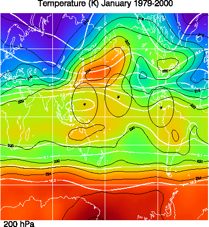
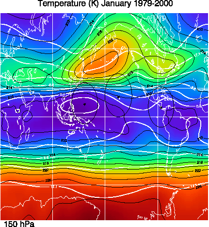
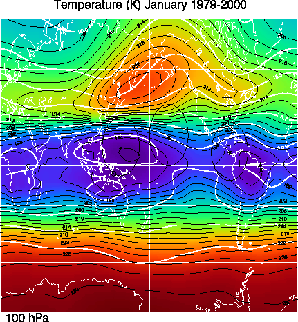
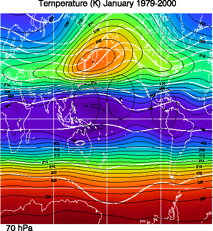
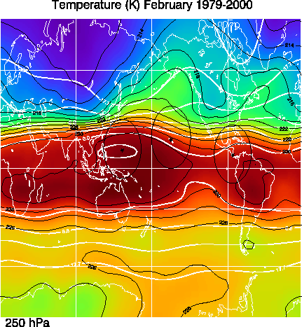
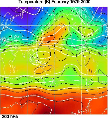
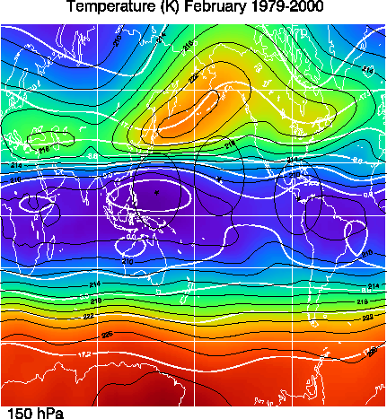
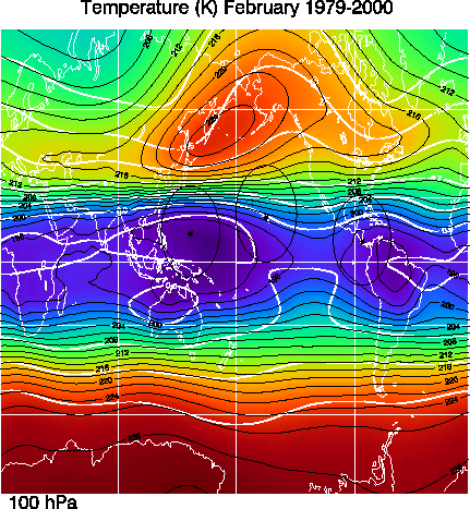
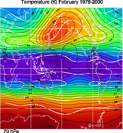
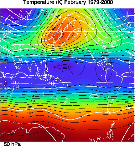
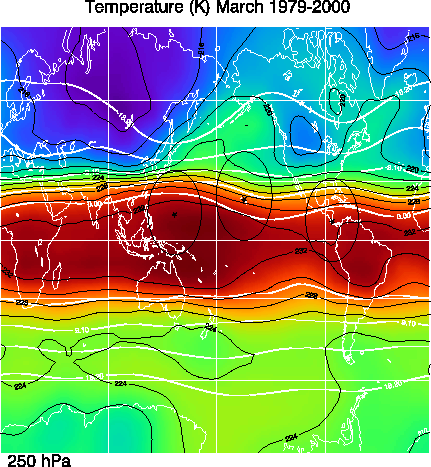
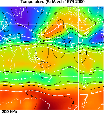
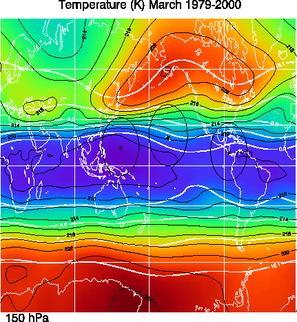
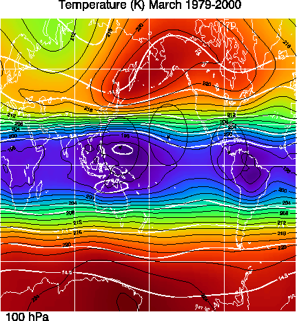
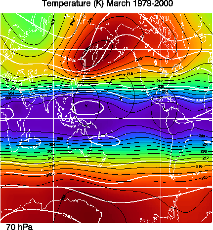
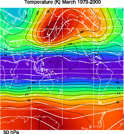
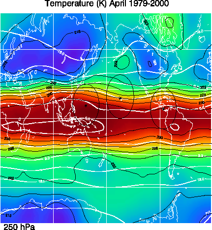
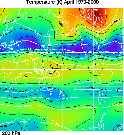
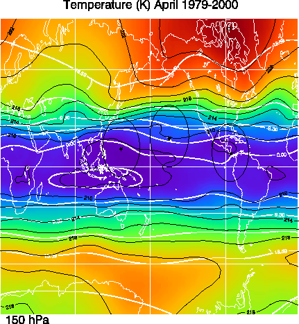
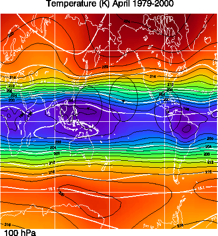
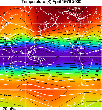
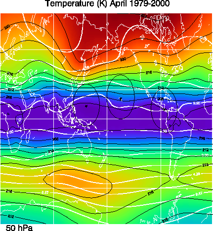
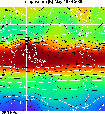
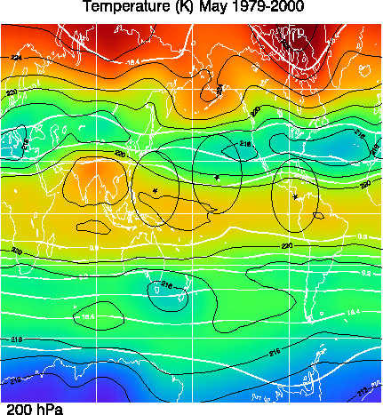
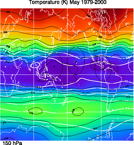
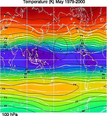
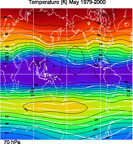
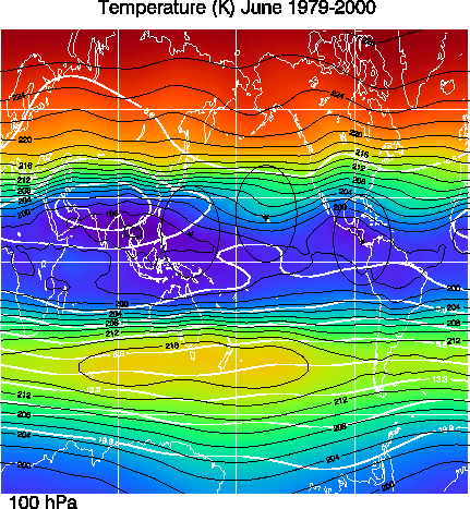
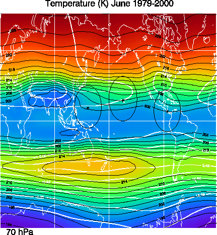
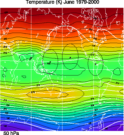
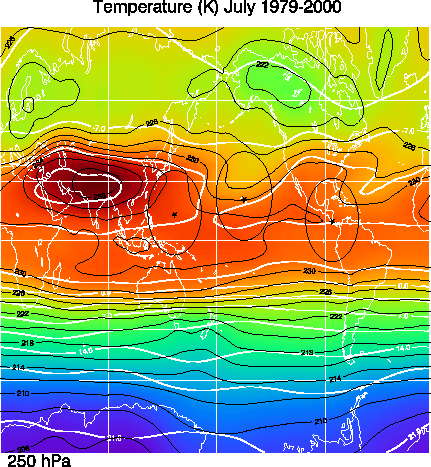
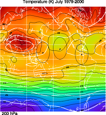
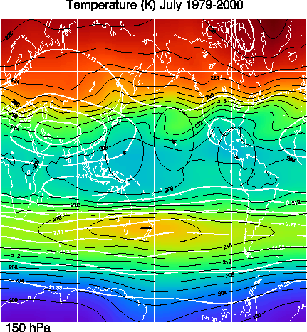
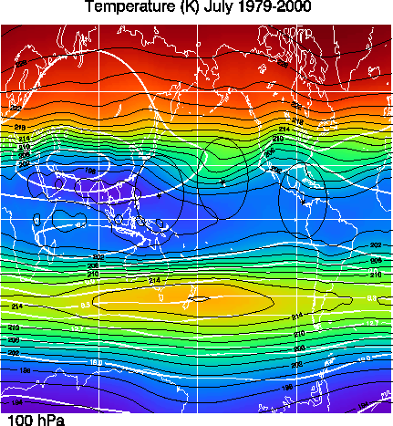
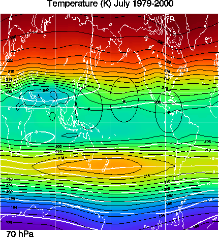
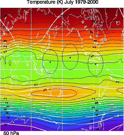
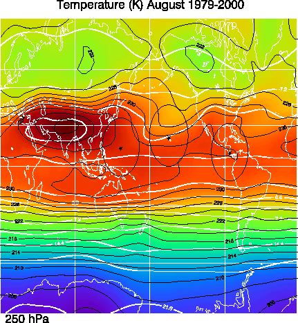
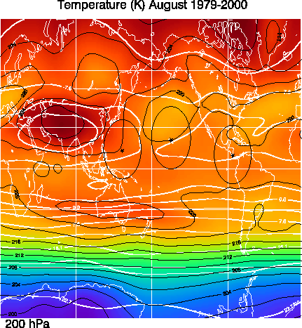
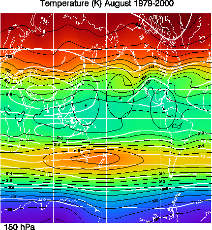
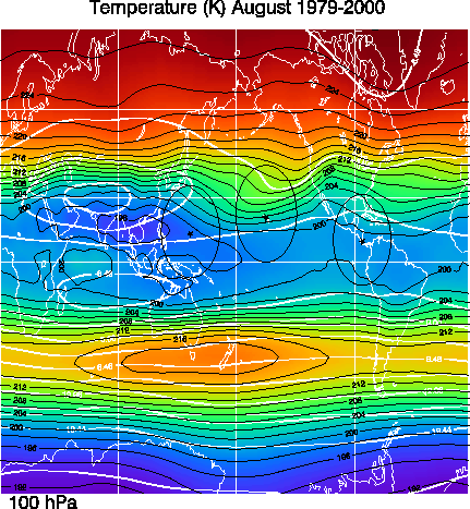
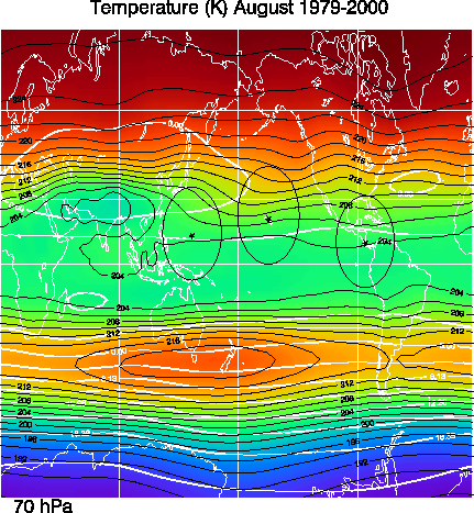
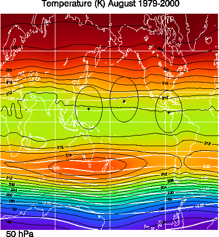
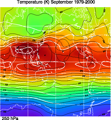
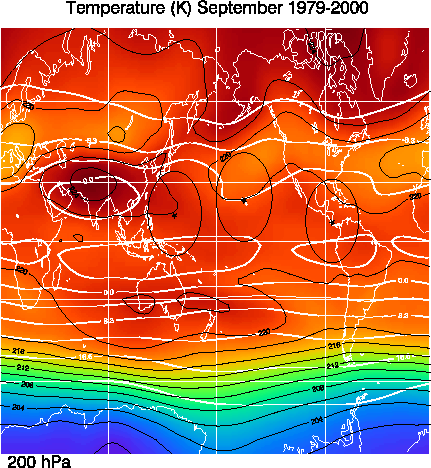
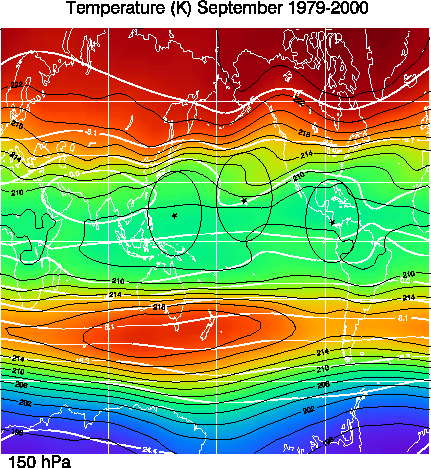
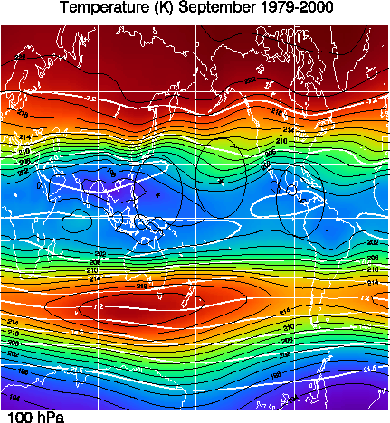
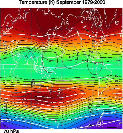
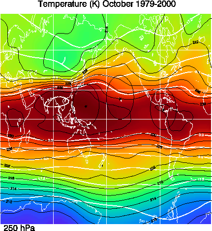
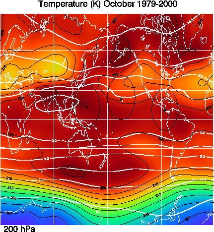
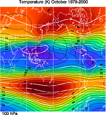
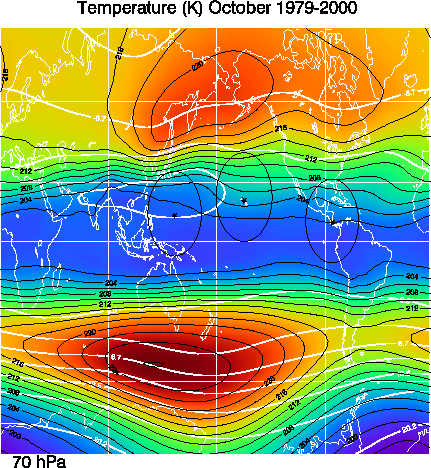
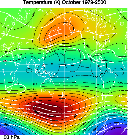
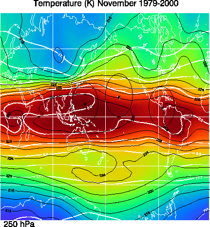
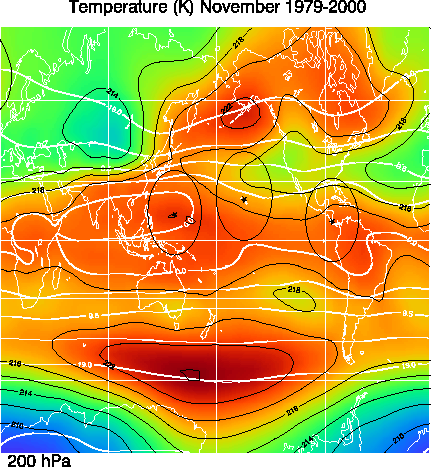
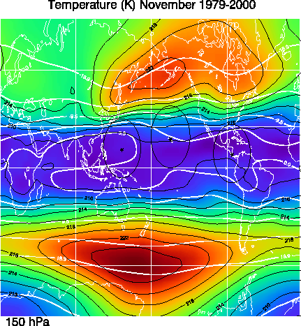
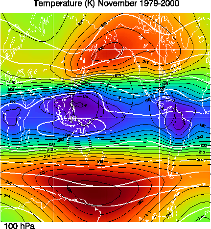
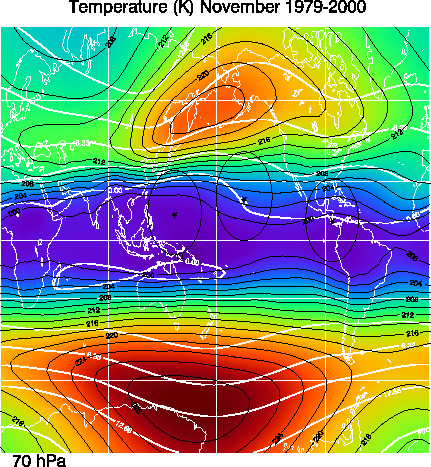
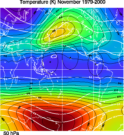
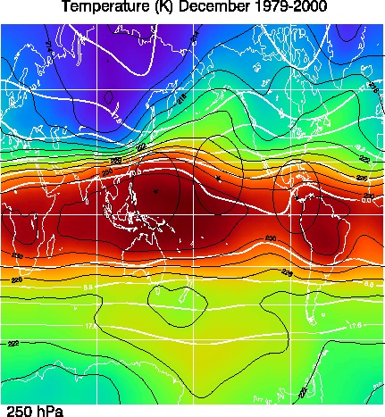
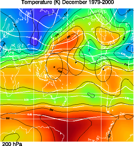
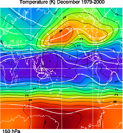
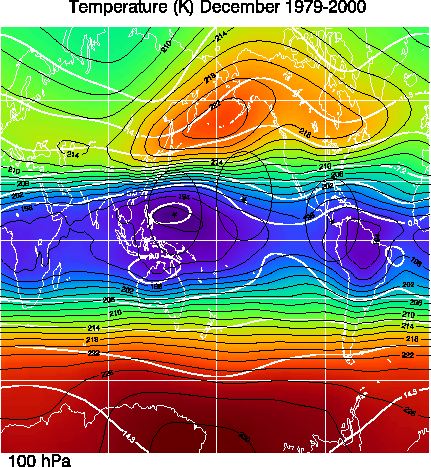
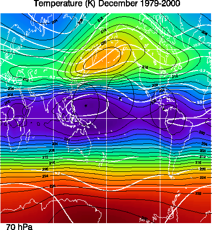
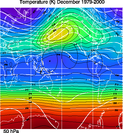
These temperature averages are derived from the NCEP/NCAR reanalysis data from 1979-2000. Contours are indicated for every 2 K while their is a color change for every 1 K. The thick solid white lines are the stream lines derived from the zonal and meridional wind averages. The stream line values have been normalized by dividing by the Earth's radius.
January 250 MB 200 MB 150 MB 100 MB 70 MB 50 MB
February 250 MB 200 MB 150 MB 100 MB 70 MB 50 MB
March 250 MB 200 MB 150 MB 100 MB 70 MB 50 MB
April 250 MB 200 MB 150 MB 100 MB 70 MB 50 MB
May 250 MB 200 MB 150 MB 100 MB 70 MB 50 MB
June 250 MB 200 MB 150 MB 100 MB 70 MB 50 MB
July 250 MB 200 MB 150 MB 100 MB 70 MB 50 MB
August 250 MB 200 MB 150 MB 100 MB 70 MB 50 MB
September 250 MB 200 MB 150 MB 100 MB 70 MB 50 MB
October 250 MB 200 MB 150 MB 100 MB 70 MB 50 MB
November 250 MB 200 MB 150 MB 100 MB 70 MB 50 MB
December 250 MB 200 MB 150 MB 100 MB 70 MB 50 MB
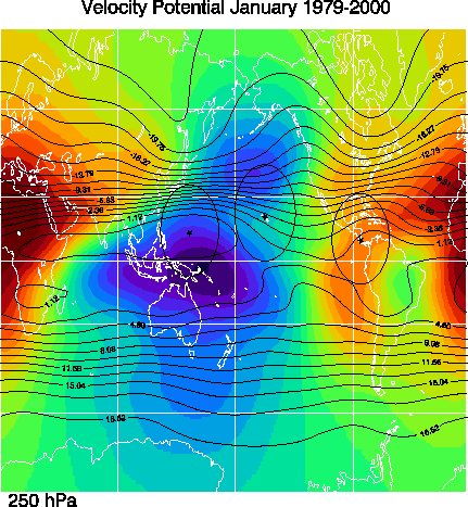
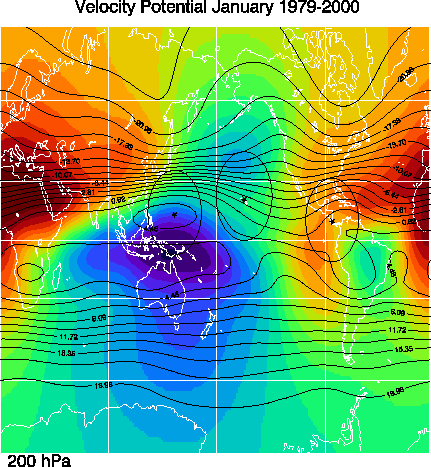
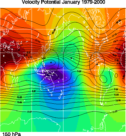
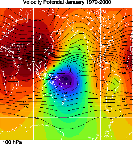
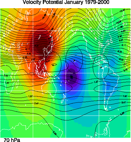
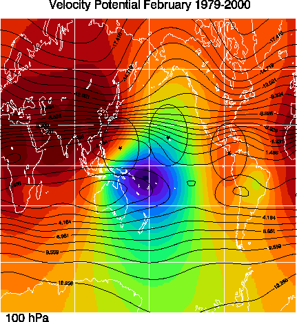
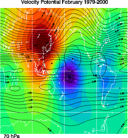
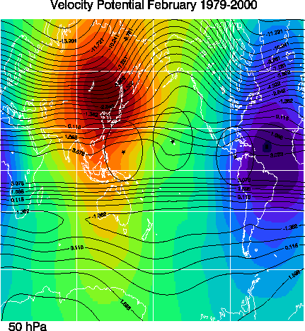
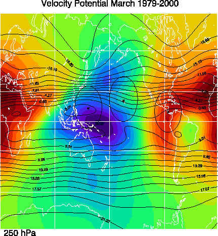
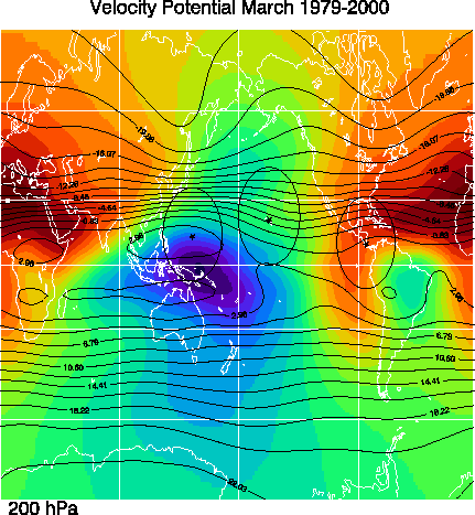
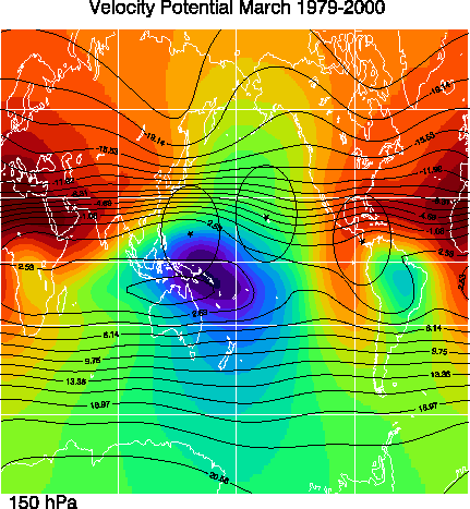
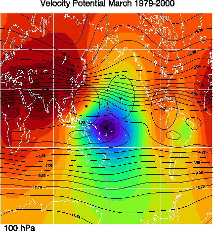
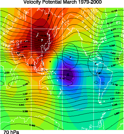
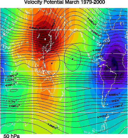
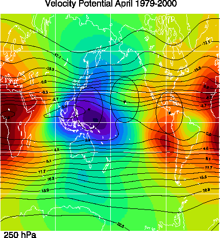
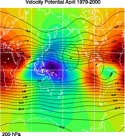
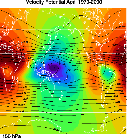
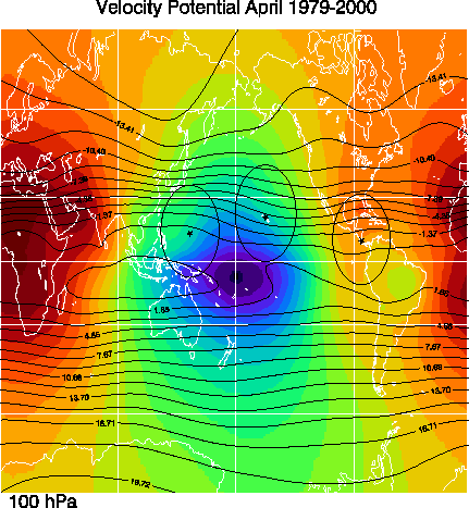
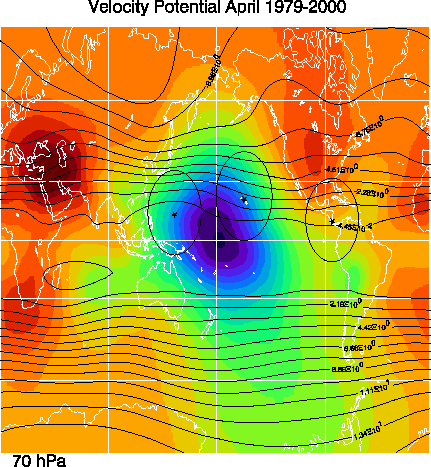
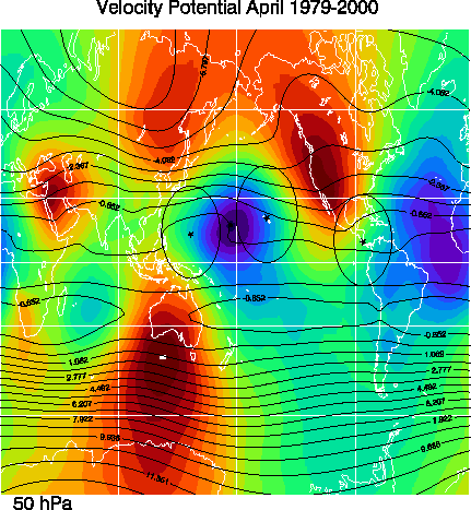
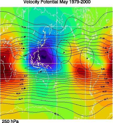
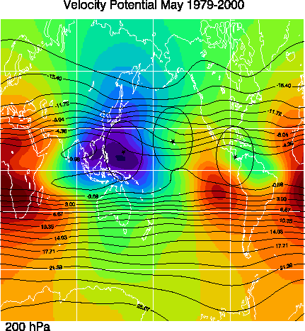
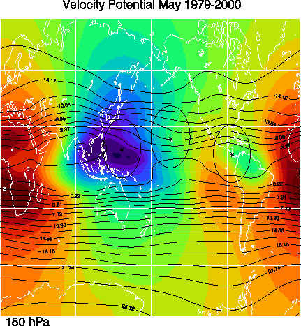
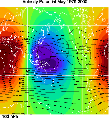
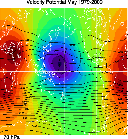
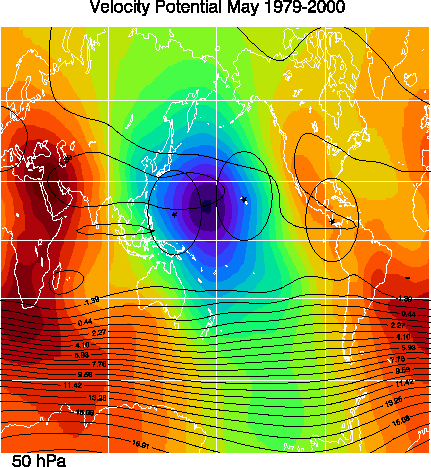
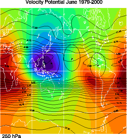
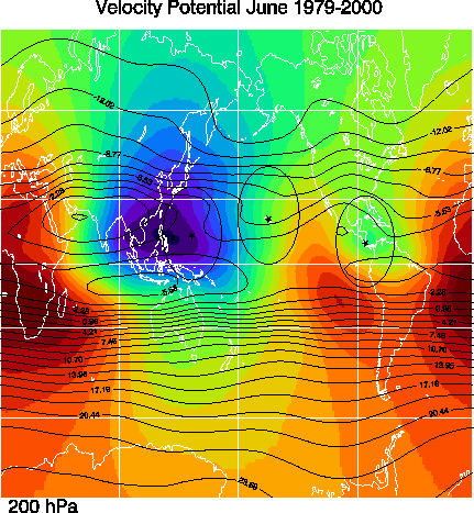
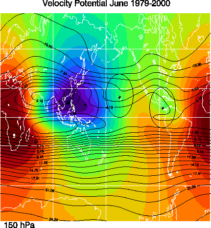
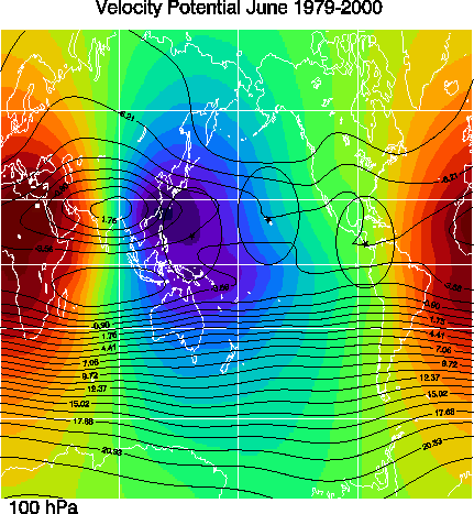
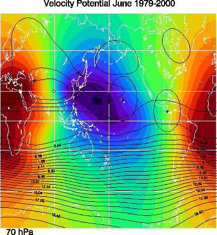
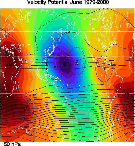
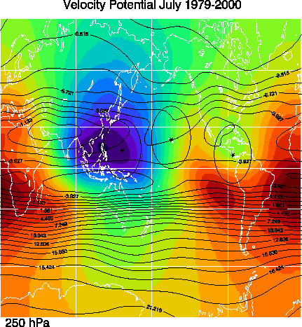
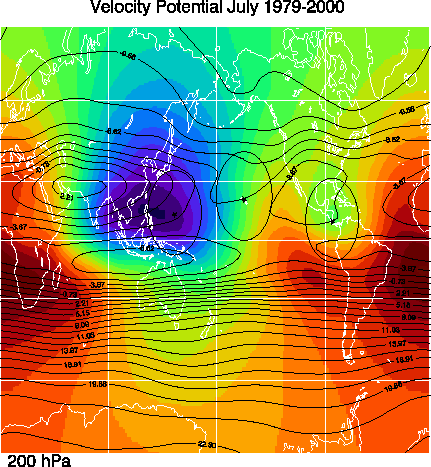
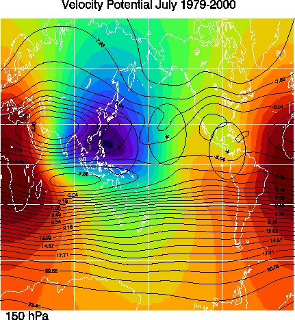
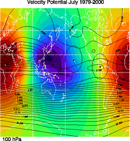
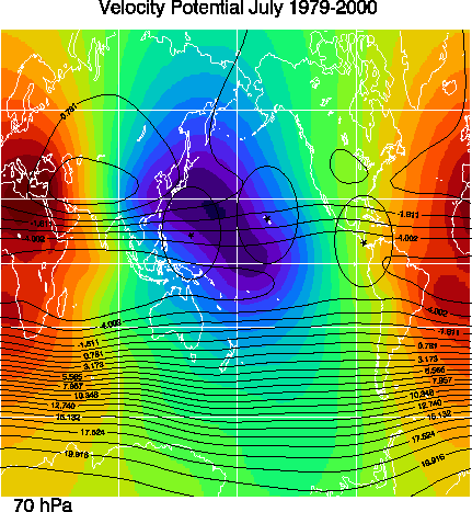
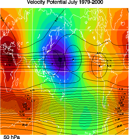
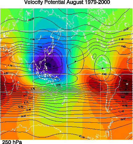
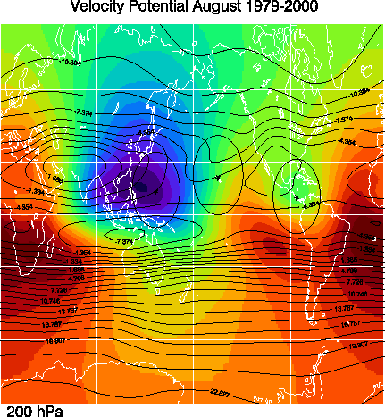
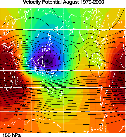
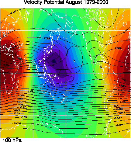
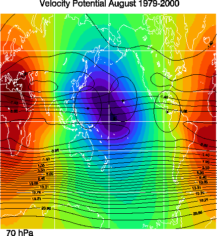
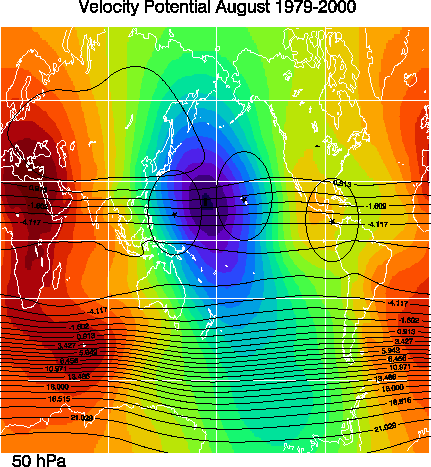
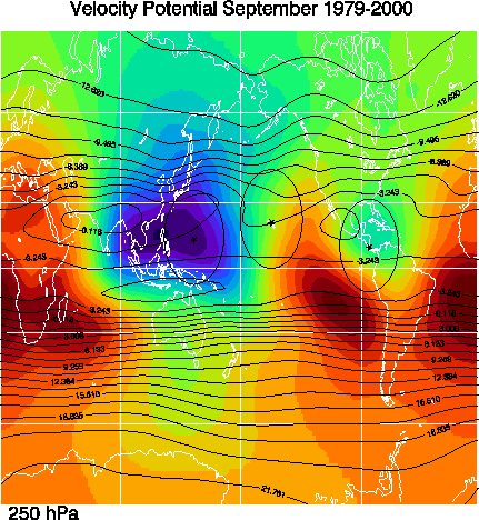
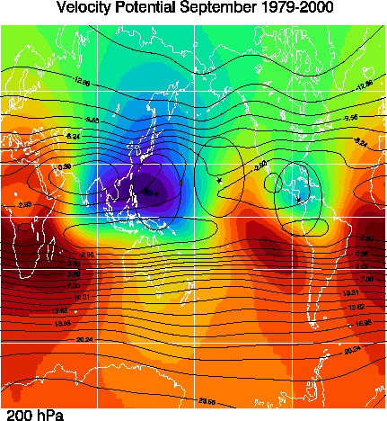
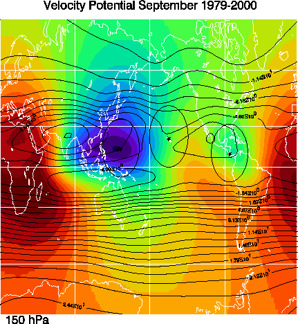
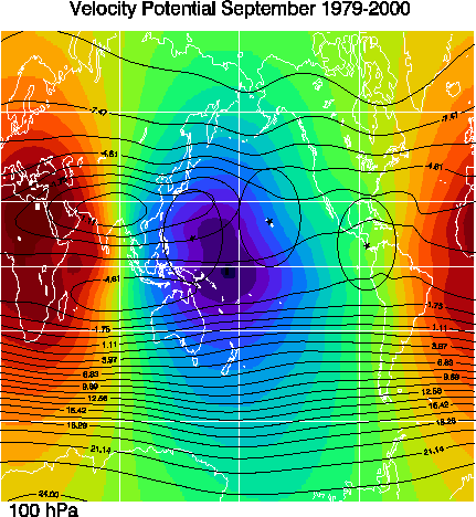
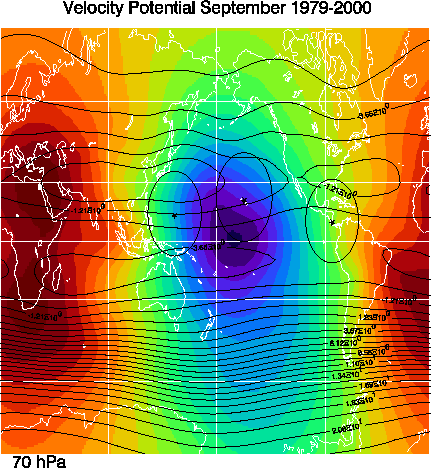
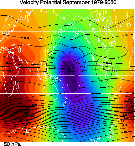
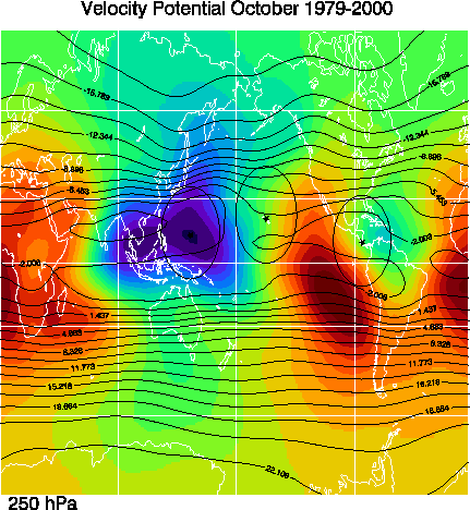
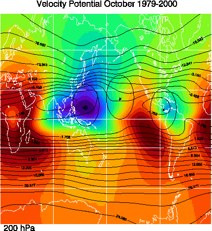
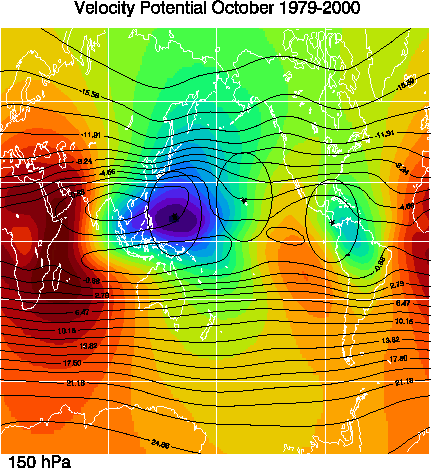
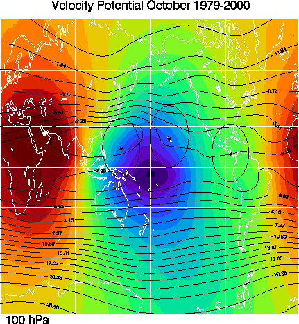
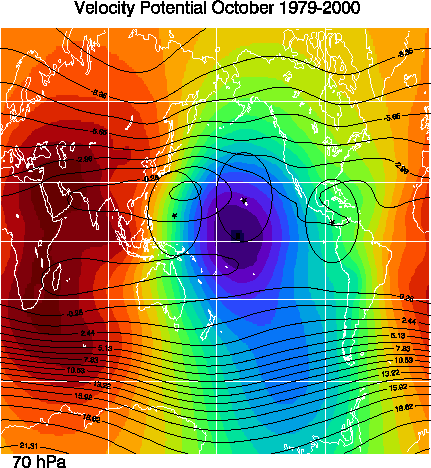
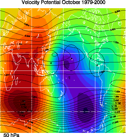
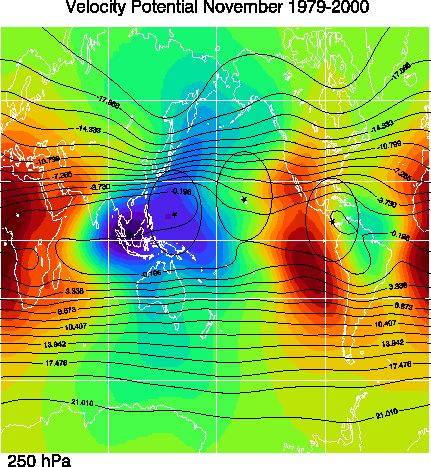
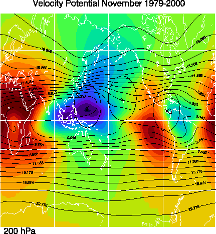
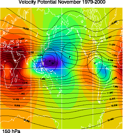
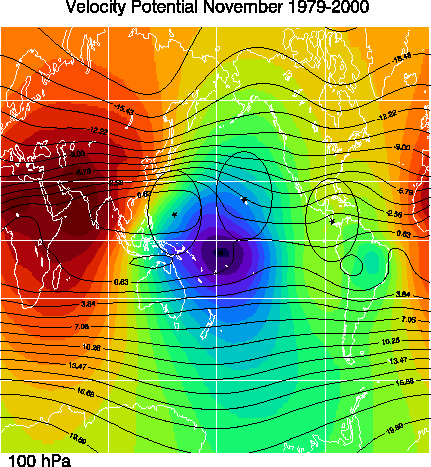
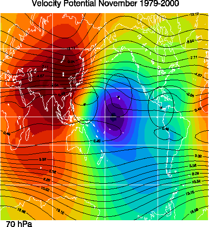
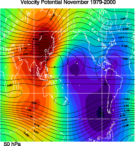
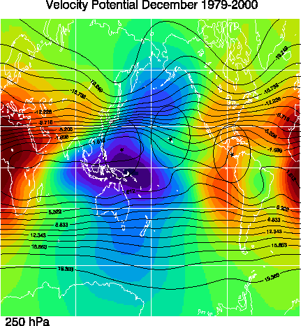
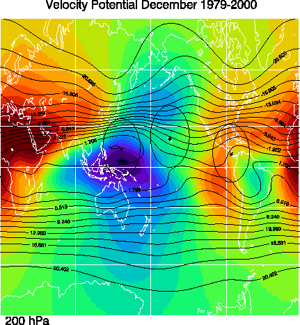
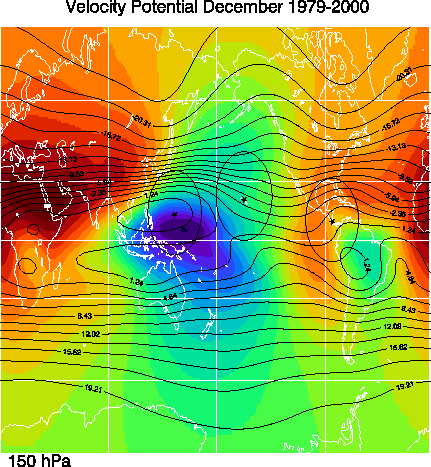
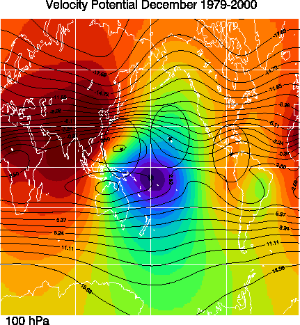
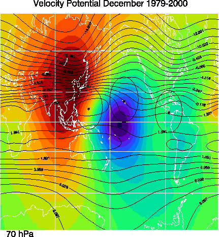
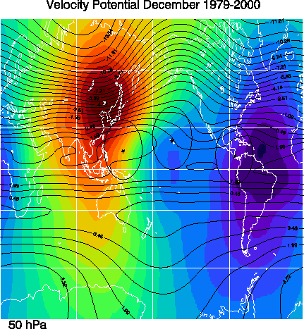
The velocity potential (color images) is derived from the divergent part of the wind field, while the streamlines (solid contours) are derived from the non-divergent part of the flow field. The divergent wind is calculated by taking the gradient of the velocity potential. Hence, air is diverging away from lows (blues and purples), and towards the highs (reds and oranges) in the color image. The divergent wind is proportional to the color spacing, and perpendicular to those color contours. The non-divergent wind is calculated by taking the curl of the streamlines. Hence, the non-divergent wind is proportional to the contour spacing, and parallel to those color contours. The stream line and velocity potential values have been normalized by dividing by the Earth's radius.
January 250 MB 200 MB 150 MB 100 MB 70 MB 50 MB
February 250 MB 200 MB 150 MB 100 MB 70 MB 50 MB
March 250 MB 200 MB 150 MB 100 MB 70 MB 50 MB
April 250 MB 200 MB 150 MB 100 MB 70 MB 50 MB
May 250 MB 200 MB 150 MB 100 MB 70 MB 50 MB
June 250 MB 200 MB 150 MB 100 MB 70 MB 50 MB
July 250 MB 200 MB 150 MB 100 MB 70 MB 50 MB
August 250 MB 200 MB 150 MB 100 MB 70 MB 50 MB
September 250 MB 200 MB 150 MB 100 MB 70 MB 50 MB
October 250 MB 200 MB 150 MB 100 MB 70 MB 50 MB
November 250 MB 200 MB 150 MB 100 MB 70 MB 50 MB
December 250 MB 200 MB 150 MB 100 MB 70 MB 50 MB
The water vapor averages are derived from either the Microwave Limb Sounder (MLS) or HALogen Occultation Experiment (HALOE) instruments on the Upper Atmosphere Research Satellite (UARS). The 215 and 147 hPa data are averages of MLS water vapor from 1991-1997, and were kindly provided by Elizabeth Stone (see Stone, E., et al., 2000: "Spatial distributions of upper tropospheric water vapor measurements from the UARS Microwave Limb Sounder", J. Geophys. Res., 103, 12149-12161.). The 100 and 68 hPa data are averages of HALOE water vapor from 1991-2000, and were kindly provided by Bill Randel (see Randel, W.R., et al. 2000: "The seasonal variation of water vapor in the lower stratosphere observed by HALOE"). Contours are indicated every 10, 2, 0.4, 0.4 ppmv for the 215, 147, 100, and 68 hPa levels, respectively.
January 215 MB 147 MB 100 MB 68 MB
February 215 MB 147 MB 100 MB 68 MB
March 215 MB 147 MB 100 MB 68 MB
April 215 MB 147 MB 100 MB 68 MB
May 215 MB 147 MB 100 MB 68 MB
June 215 MB 147 MB 100 MB 68 MB
July 215 MB 147 MB 100 MB 68 MB
August 215 MB 147 MB 100 MB 68 MB
September 215 MB 147 MB 100 MB 68 MB
October 215 MB 147 MB 100 MB 68 MB
November 215 MB 147 MB 100 MB 68 MB
December 215 MB 147 MB 100 MB 68 MB
The Outgoing Longwave Radiation (OLR) plots show 1979-1995 averages of interpolated OLR data obtained from the NOAA-CIRES Climate Diagnostics Center (http://www.cdc.noaa.gov/). See Liebmann and Smith (Bulletin of the American Meteorological Society, June 1996) for description of the interpolation technique. Contour interval is every 10 W/m2.
Jan Feb Mar Apr May Jun Jul Aug Sep Oct Nov Dec
Time avearges for indivuals year 1979-2002 for January and July
January 1979 500 MB 400 MB 300 MB 250 MB 200 MB 150 MB 100 MB 70 MB
January 1980 500 MB 400 MB 300 MB 250 MB 200 MB 150 MB 100 MB 70 MB
January 1981 500 MB 400 MB 300 MB 250 MB 200 MB 150 MB 100 MB 70 MB
January 1982 500 MB 400 MB 300 MB 250 MB 200 MB 150 MB 100 MB 70 MB
January 1983 500 MB 400 MB 300 MB 250 MB 200 MB 150 MB 100 MB 70 MB
January 1984 500 MB 400 MB 300 MB 250 MB 200 MB 150 MB 100 MB 70 MB
January 1985 500 MB 400 MB 300 MB 250 MB 200 MB 150 MB 100 MB 70 MB
January 1986 500 MB 400 MB 300 MB 250 MB 200 MB 150 MB 100 MB 70 MB
January 1987 500 MB 400 MB 300 MB 250 MB 200 MB 150 MB 100 MB 70 MB
January 1988 500 MB 400 MB 300 MB 250 MB 200 MB 150 MB 100 MB 70 MB
January 1989 500 MB 400 MB 300 MB 250 MB 200 MB 150 MB 100 MB 70 MB
January 1990 500 MB 400 MB 300 MB 250 MB 200 MB 150 MB 100 MB 70 MB
January 1991 500 MB 400 MB 300 MB 250 MB 200 MB 150 MB 100 MB 70 MB
January 1992 500 MB 400 MB 300 MB 250 MB 200 MB 150 MB 100 MB 70 MB
January 1993 500 MB 400 MB 300 MB 250 MB 200 MB 150 MB 100 MB 70 MB
January 1994 500 MB 400 MB 300 MB 250 MB 200 MB 150 MB 100 MB 70 MB
January 1995 500 MB 400 MB 300 MB 250 MB 200 MB 150 MB 100 MB 70 MB
January 1996 500 MB 400 MB 300 MB 250 MB 200 MB 150 MB 100 MB 70 MB
January 1997 500 MB 400 MB 300 MB 250 MB 200 MB 150 MB 100 MB 70 MB
January 1998 500 MB 400 MB 300 MB 250 MB 200 MB 150 MB 100 MB 70 MB
January 1999 500 MB 400 MB 300 MB 250 MB 200 MB 150 MB 100 MB 70 MB
January 2000 500 MB 400 MB 300 MB 250 MB 200 MB 150 MB 100 MB 70 MB
January 2001 500 MB 400 MB 300 MB 250 MB 200 MB 150 MB 100 MB 70 MB
January 2002 500 MB 400 MB 300 MB 250 MB 200 MB 150 MB 100 MB 70 MB
July 1979 500 MB 400 MB 300 MB 250 MB 200 MB 150 MB 100 MB 70 MB
July 1980 500 MB 400 MB 300 MB 250 MB 200 MB 150 MB 100 MB 70 MB
July 1981 500 MB 400 MB 300 MB 250 MB 200 MB 150 MB 100 MB 70 MB
July 1982 500 MB 400 MB 300 MB 250 MB 200 MB 150 MB 100 MB 70 MB
July 1983 500 MB 400 MB 300 MB 250 MB 200 MB 150 MB 100 MB 70 MB
July 1984 500 MB 400 MB 300 MB 250 MB 200 MB 150 MB 100 MB 70 MB
July 1985 500 MB 400 MB 300 MB 250 MB 200 MB 150 MB 100 MB 70 MB
July 1986 500 MB 400 MB 300 MB 250 MB 200 MB 150 MB 100 MB 70 MB
July 1987 500 MB 400 MB 300 MB 250 MB 200 MB 150 MB 100 MB 70 MB
July 1988 500 MB 400 MB 300 MB 250 MB 200 MB 150 MB 100 MB 70 MB
July 1989 500 MB 400 MB 300 MB 250 MB 200 MB 150 MB 100 MB 70 MB
July 1990 500 MB 400 MB 300 MB 250 MB 200 MB 150 MB 100 MB 70 MB
July 1991 500 MB 400 MB 300 MB 250 MB 200 MB 150 MB 100 MB 70 MB
July 1992 500 MB 400 MB 300 MB 250 MB 200 MB 150 MB 100 MB 70 MB
July 1993 500 MB 400 MB 300 MB 250 MB 200 MB 150 MB 100 MB 70 MB
July 1994 500 MB 400 MB 300 MB 250 MB 200 MB 150 MB 100 MB 70 MB
July 1995 500 MB 400 MB 300 MB 250 MB 200 MB 150 MB 100 MB 70 MB
July 1996 500 MB 400 MB 300 MB 250 MB 200 MB 150 MB 100 MB 70 MB
July 1997 500 MB 400 MB 300 MB 250 MB 200 MB 150 MB 100 MB 70 MB
July 1998 500 MB 400 MB 300 MB 250 MB 200 MB 150 MB 100 MB 70 MB
July 1999 500 MB 400 MB 300 MB 250 MB 200 MB 150 MB 100 MB 70 MB
July 2000 500 MB 400 MB 300 MB 250 MB 200 MB 150 MB 100 MB 70 MB
July 2001 500 MB 400 MB 300 MB 250 MB 200 MB 150 MB 100 MB 70 MB
July 2002 500 MB 400 MB 300 MB 250 MB 200 MB 150 MB 100 MB 70 MB
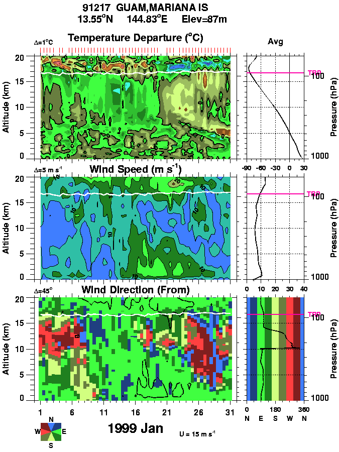
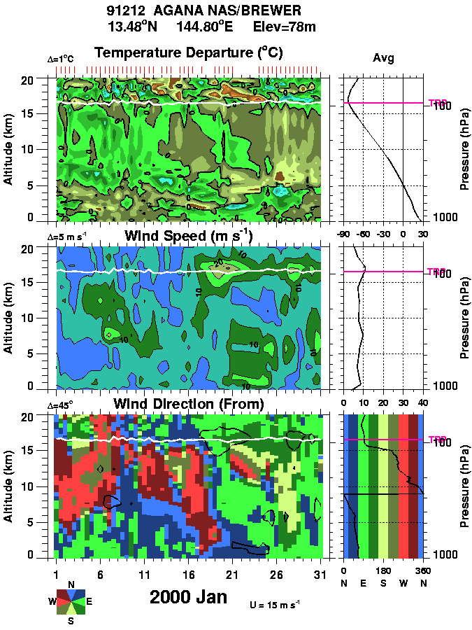
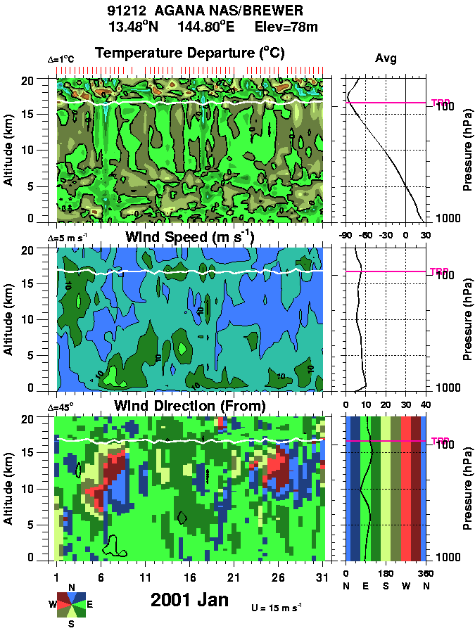
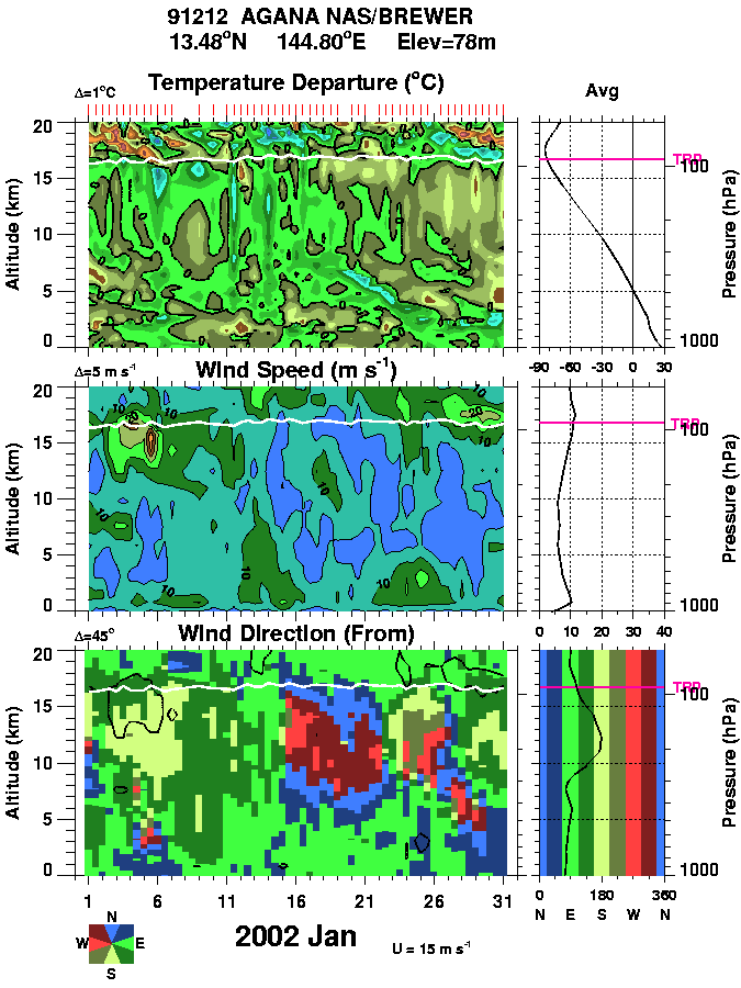
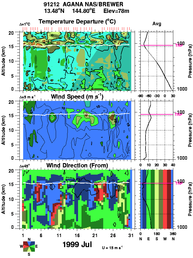
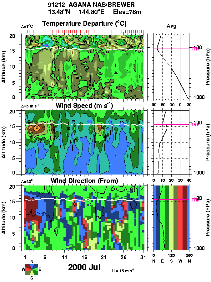
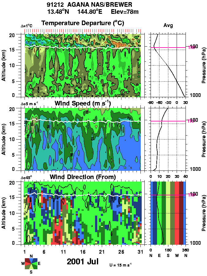
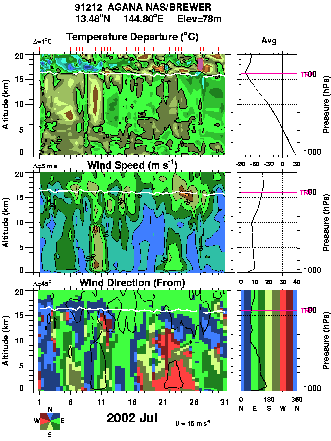
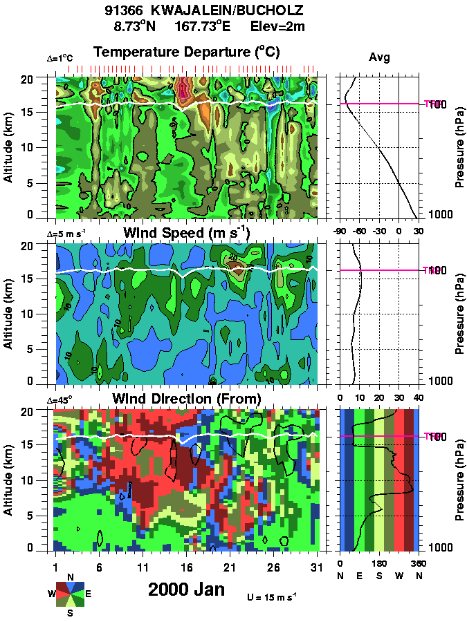
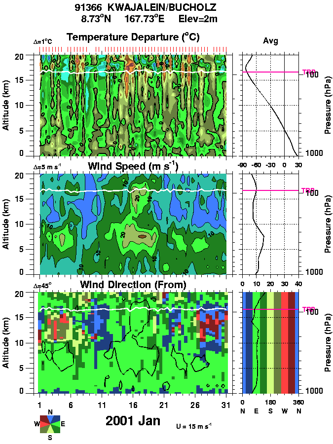
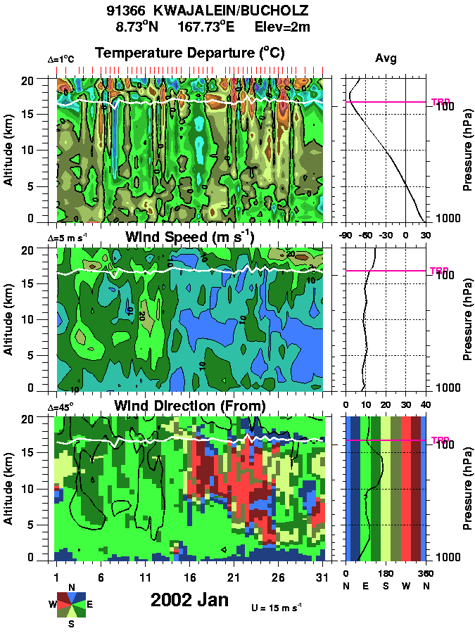
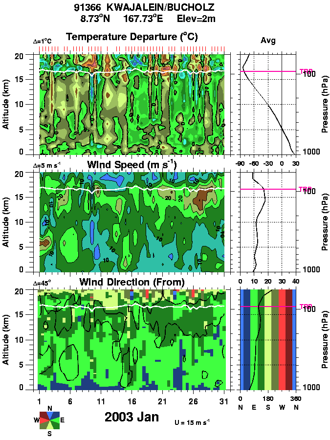
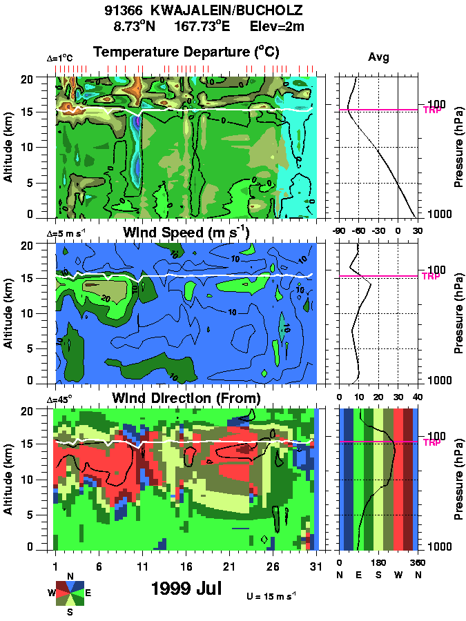
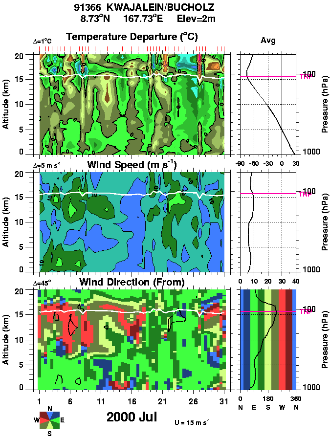
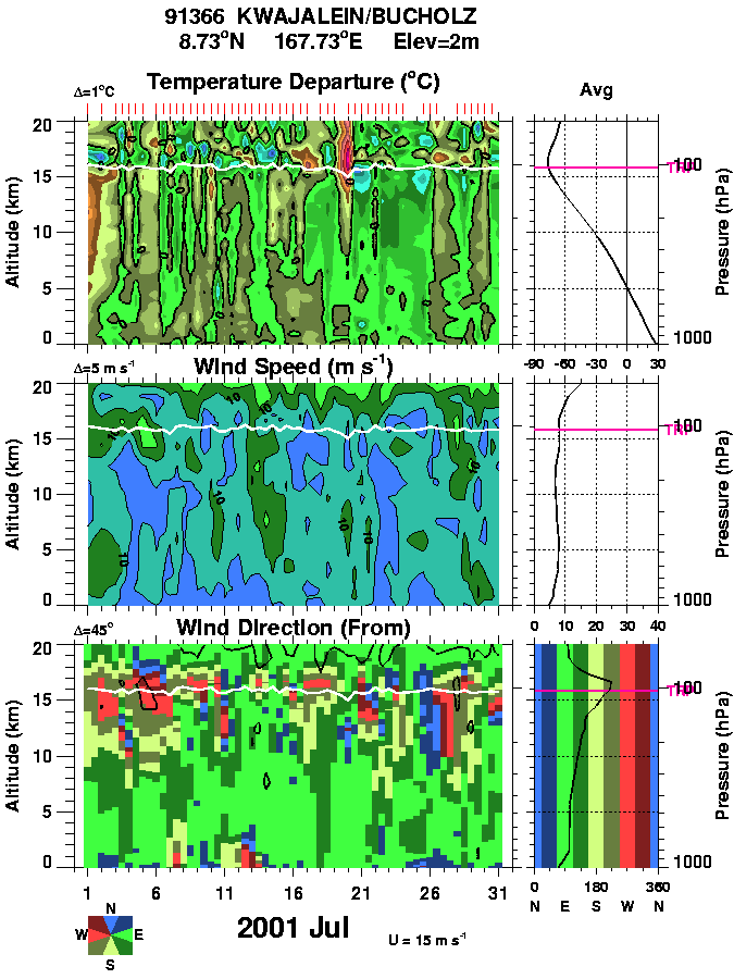
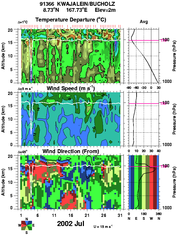
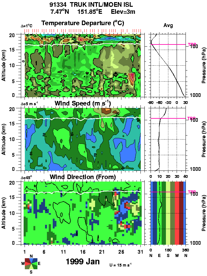
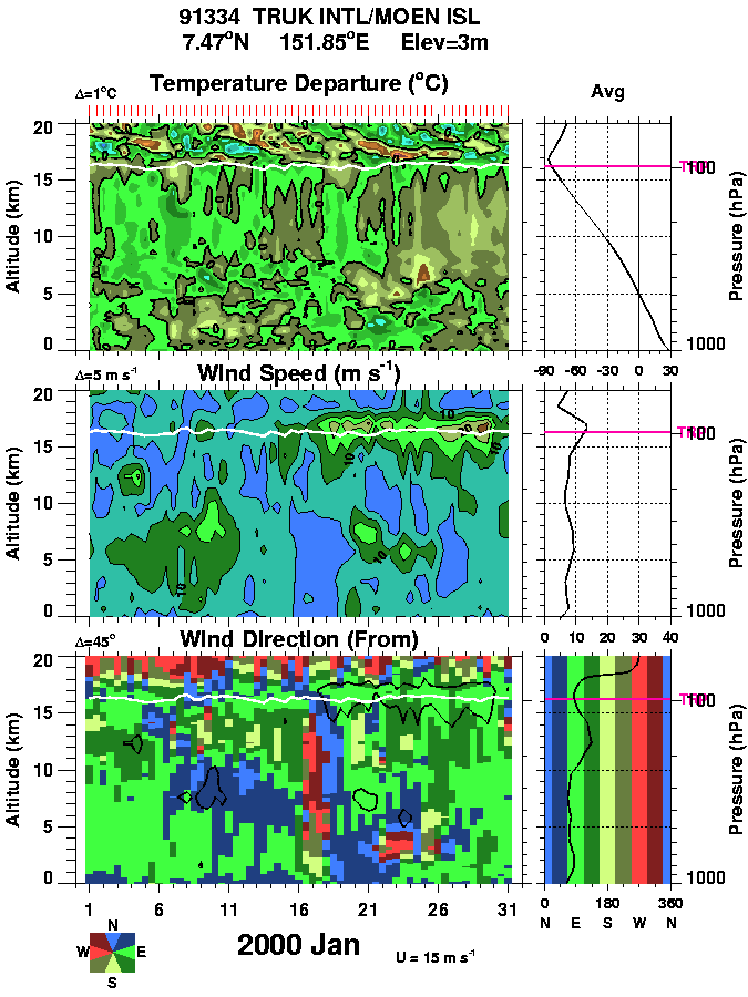
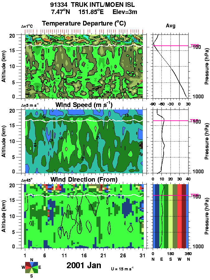
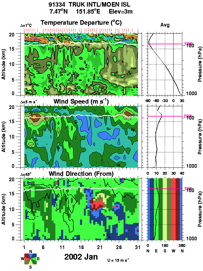
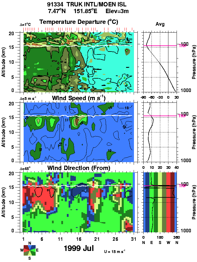
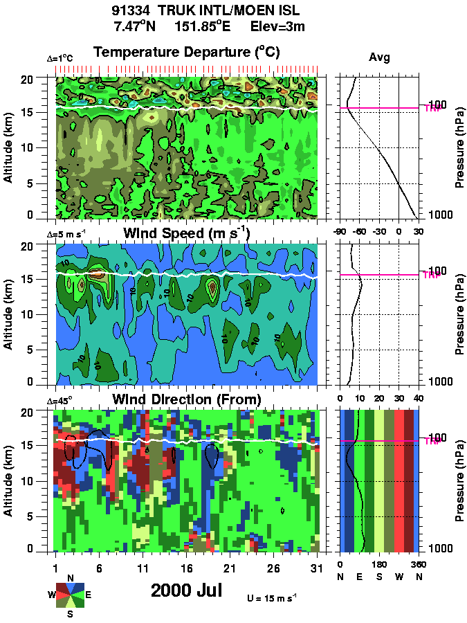
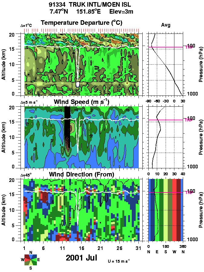
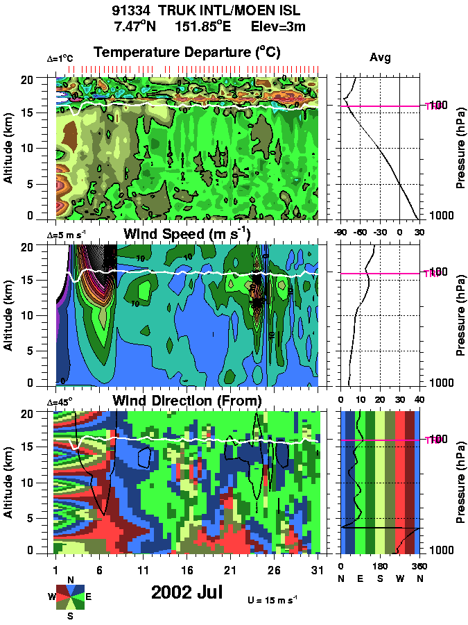
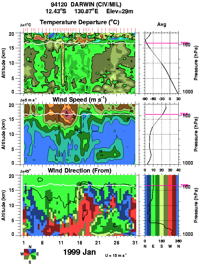
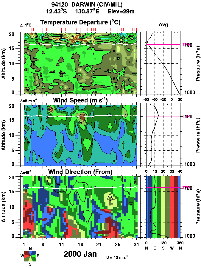
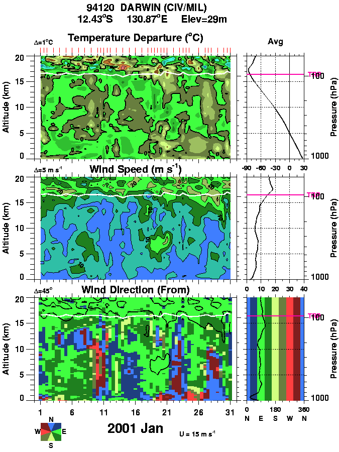
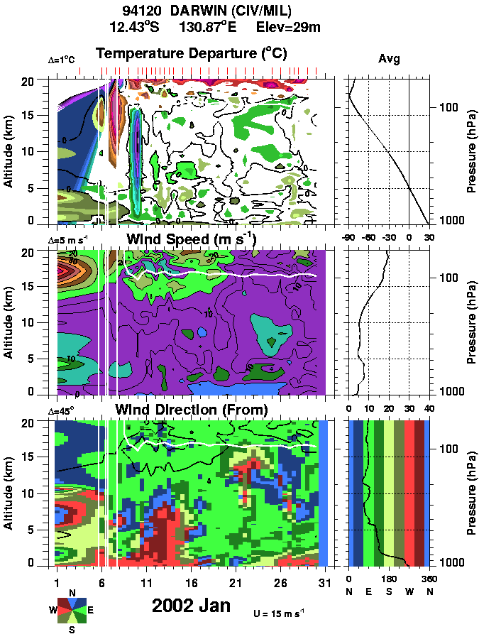
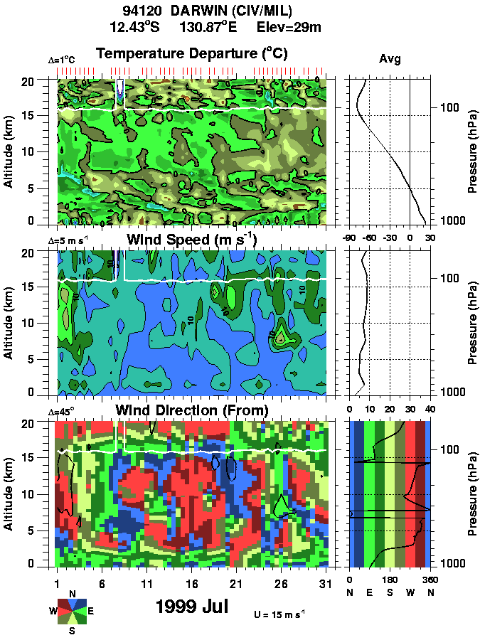
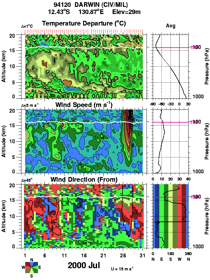
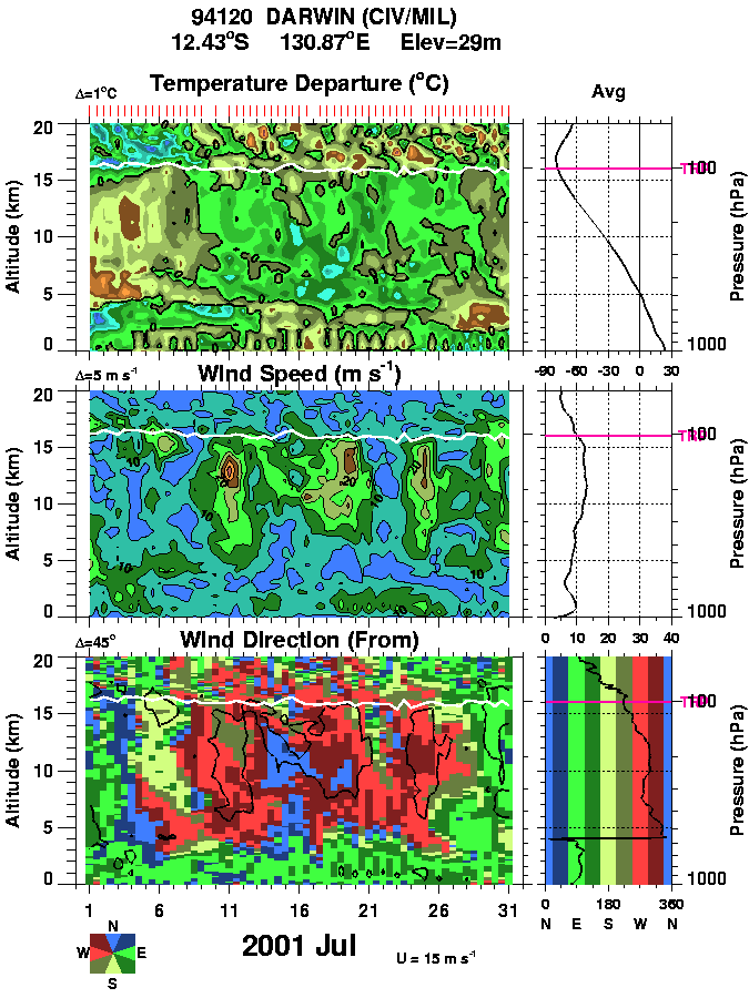
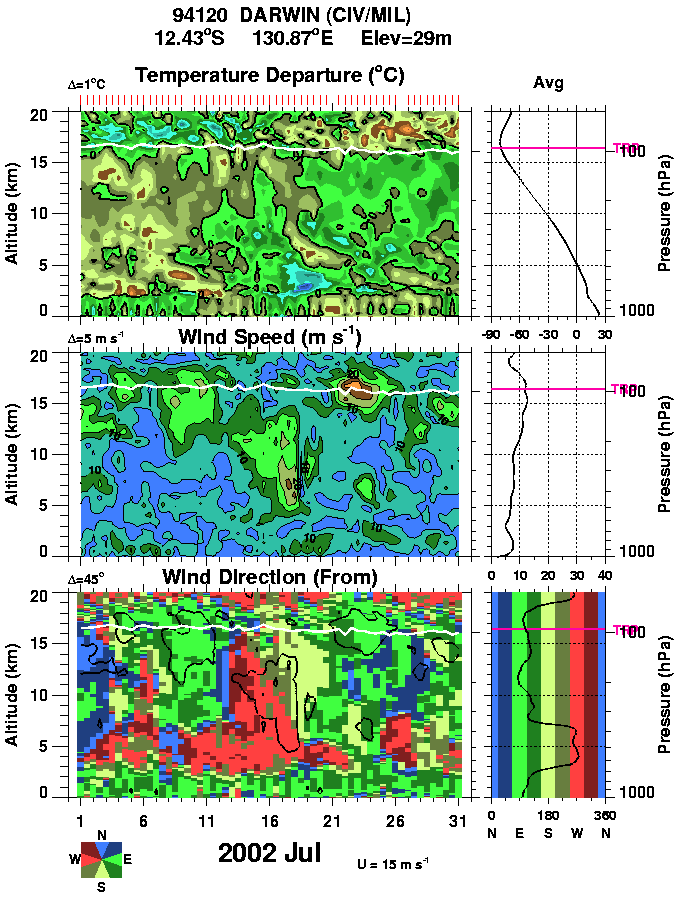
There are 3 color panels on each plot for Temperature (top), wind Speed (middle), and wind direction (bottom) as a function of altitude (0-20 km) and time (May 15 to July 15). The time-mean profiles are shown on each plot on the right hand side. The tropopause is indicated by the white line on each plot. The red ticks just above the temperature plot show the actual sonde launches. The color coding on the wind direction is indicated by the compass rose on the just below the wind direction chart (note that westerlies are red and easterlie are green.
Agama NAS (Guam) January 1999 2000 2001 2002 July 1999 2000 2001 2002
Kwajalein January 1999 2000 2001 2002 2003 July 1999 2000 2001 2002
Truk January 1999 2000 2001 2002 July 1999 2000 2001 2002
Darwin January 1999 2000 2001 2002 July 1999 2000 2001 2002
Dr. Paul A. Newman
Code 916
Atmospheric Chemistry and Dynamics Branch
Laboratory for Atmospheres
NASA's Goddard Space Flight Center
Greenbelt, MD 20771
Building 33, Room E320
(301) 614-5985 fax: x-5903
Last Updated: 2000-09-02
Author: Dr. Paul A. Newman
(NASA/GSFC, Code 916) (newman@notus.gsfc.nasa.gov)