SOLVE Journal
SOLVE Phase 1
Dr.
Paul A. Newman
Code 916
Atmospheric Chemistry and
Dynamics Branch
Laboratory
for Atmospheres
NASA's Goddard
Space Flight Center
Greenbelt, MD 20771
Building 33, Room E320
(301) 614-5985 fax: x-5903
Friday 1999-12-17
Brian Toon reports on the 10.5 hour transit flight back to Dryden from
Kiruna:
Took off at 8:57 UT
On climb out, the local tropopause height was 31 kft. This is
significantly higher than forecast (about 27 kft). A cloud deck with
tops near 6 km was observed by LASE. DIAL sees distinct layering
in the stratospheric aerosol layer between 15 and 20 km, with a wavelength
of about 1 km. DIAL and AROTEL report similar layers in ozone with
a peak-to-peak amplitude of about 500 ppb. DIAL reports that the
ozone minima and the aerosol minima coincide, which suggests these features
are due to upward sloping transport rather than temperature oscillations.
At 10:38 the observed tropopause was near 30 kft, while the predicted tropopause
was much lower (27 kft). The various layers seen by DIAL aerosol
have been sloping upward and fading, though one distinct layer remains
near 20 km. AROTEL also sees a distinct ozone peak near 21 km, which
is about 3 km across in the vertical. Near the Greenland coast at
10:47, AROTEL temperatures are near 196 to 197 from 20 to 24 km.
At 10:58, with 11 min to the Greenland coast, the temperatures seem to
be about 190 at 22 km and 195 at 20; however, AROTEL is shortening their
sampling cycle and temperatures are changing by about 5 K between averaging
periods. The tropopause here is at 32 kft. We encountered light
turbulence near the Greenland coast. Clouds are clearly visible on
the southern horizon, which is slightly sunlit. These appear to be
near or slightly above the aircraft altitude; however, LASE did not see
any clouds below the aircraft. MTP reports significant variation
in the isentropes near flight level; they suggest a wave amplitude of about
500 m. It does seem that there is significant wave activity here,
but no indications of PSCs. DIAL also sees about a 50-m amplitude
wave in the aerosol near 12 km, and some wave structure in ozone over a
15 min period near 15 km. AROTEL sees a lot of layers in the ozone mixing
ratio, and some layering in the temperatures. No PSCs were seen in
the cool pool over Greenland.
As we approached the west coast of Greenland, in situ particles and
ozone began to show large anti-correlated fluctuations. Temperature
and potential temperature do not seem to be clearly correlated with ozone
or particles. AROTEL reported ozone oscillations below 18 km, with
a 500 ppb amplitude and 2 K, near 13:30, DIAL again sees multiple distinct
layers in the stratospheric aerosols up to about 20 km. Waves are
also present in DIAL ozone. Near 15:08, we crossed the polar night
jet and entered the troposphere. We elected to remain at 35 kft so
that we could look for NOy and HNO3 on the light cirrus deck located there.
We did see NOy on ice crystals. It is not clear if CIMS saw any loss
of gas phase nitric acid. The NOy instrument does not see a loss
of gashes NOy.
At about 15:45, we encountered a layer between 16 and 18 km with an
infrared backscatter ratio of 0.1 to 0.15. The layer was not depolarizing.
MTP indicated that the temperature in this region was about 215 K.
This possibly could be a remnant of some small volcanic eruption.
The layer faded after 30 minutes, but other similar layers reappeared for
the next hour. Essentially the entire region from the edge of the
vortex to Dryden contained this layer. The backscatter seems larger
than seen previously in the mission. Normalizing at 15 km altitude,
the infrared scattering ratio seems to be about 0.4, which is moderately
large. m vertical wavelength.
Thursday 1999-12-16
This first SOLVE deployment is winding to a close. The DC-8
should arrive back here at Dryden this morning, and Leslie Lait tells me
that he's been locked out of the labs back in Kiruna by Mike Craig.
Tomorrow's our drop-dead date for the ER-2 group as we continue to try
and resolve our radio problems. "Louie, Louie, oh no, baby we gotta
go now. yah, yah, yah, yah, yah, yah." I'm onto a flight tomorrow
up to Seattle for Christmas and New Years, while most of our group is either
bailing tomorrow or Saturday. We have a couple of sad exceptions
(Kathy Perkins and Eric Lanzendorf) who need to some laser alignment and
lab work on the Harvard NO2 instrument.
Yesterday we did the load in record time. Practice makes perfect.
While the flight was quite short, Paul Wennberg tells me that the CIMS
instrument had a very nice flight yesterday. Not much to report from the
other instruments.
Today will be the fourth 7-9-11 load-up drill in a row for the ER-2
group. The weather looks good this morning, at launch time
the winds will be 10 kts with about a 1 kt cross wind. The temperature
was 24 F when I came in this morning. Overall, the load went swiftly
and flawlessly. At this time, the ER-2 is being prepared for flight
by the crew. The ER-2 took off at about 11 AM, and the VHF radios
worked well for the first part of the flight.
The DC-8 landed at about 11:20 AM, and then sat on the ramp for about
30 minutes while they waited for the customs agents. Tom McGee, Walt
Hoegy, Don Silbert and John Burris (AROTEL
lidar) climbed off the plane, ate a few slices of pizza, and then boarded
a bus for the LA airport. Larry
Twigg also climbed off the DC-8, but Larry had some issues to deal
with, and so he's flying out tomorrow. Larry is sitting here with
me, and he reports:
I'd really like to get my long johns off now that I've reached
a warmer climate. It was about -4 F at the Kiruna airport when we
left. The flight was great, most of the instruments worked and we
crossed the polar night jet and the sub-tropical jet. The AROTEL
lidar saw some wave structure just off the Greenland coastline, and we
were able to make ozone measurements down to a solar zenith angle of 62
degrees. It's been a long haul, and I'm looking forward to getting
back home and doing my Xmas shopping.
Glen Sachse's DACOM
in-situ DC-8 instrument was picking up some interesting methane features
during this flight series. These features were very short in
duration but very high concentrations of methane. Methane (CH4) is
produced by ruminant animals such as cows and in swamp gas from decaying
vegative material. The press treats this in a joking manner by referring
to cow farts. On one of the flights, one of the DACOM operators observed
a temporal correlation between the methane spike and a person exiting the
forward bathroom of the DC-8. Further investigation revealed that
the vent for the toilet tank was located just forward of the DACOM inlet.
Each time someone flushed the toilet, the stirring tank vented a bit of
gas. Congratulations to DACOM for developing the DC-8 Forward Airborne
Retrieval Technique (DC-8 FART).
Wednesday 1999-12-15
I hope all of you people up at AGU meeting in San Francisco are having
fun this week!
For the ER-2, it's the same drill, but a different day. The radio
noise problem kept us on the ground yesterday, but we've made significant
progress in cleaning up. We need 2 working VHF radios (one for transmitting
and one for receiving) for our flights over various European countries,
hence, we've got to make sure they're working with our payload before we
leave for Kiruna. Joe Demusz of the Harvard group and Ray Scarborough
of NASA Dryden worked with the crew on this problem all day yesterday and
till late last night. It seems that noise from the Global Positioning
System (GPS) and the navigation recorder are leaking into the radios.
If you've seen interference on radios and TVs from nearby electronics (e.g.,
vacuum cleaners, blenders, microwave ovens) then you know our problem.
Their is so much stuff on the ER-2 it's very hard to trace this problem,
so we're deeply grateful for the help provided by Joe and Ray.
We started loading the ER-2 at 7 AM, hands-off the plane at 9, and tried
to launch at 11 AM. The radios worked fine for the mobile pilot,
but as soon as our pilot (Dee Porter) climbed into the cockpit the radios
began to fail. At first, the radio wouldn't work while the plane
was on ground cart power, so we recycled power on one part of the airplane
(the upper q-bay) and the radio started to work. Then after we went
to aircraft power, the noise on the radio was so bad that the pilot could
barely communicate with the Edwards tower. Eventually he took off
at 11:30 AM for the 8 hour flight down to the tropics, but the radio immediately
began to create problems. The pilot eventually aborted the flight
and landed at about 1:00 PM local time. Dee Porter commented, "In
all the years I've been flying, I've never worked so hard on an hour and
a half flight." We all filed upstairs to the conference room for
the pilot debriefing, and then the fire alarm began ringing. When
it rains, it pours.
Because of these radio problems, it has been decided to go back to the
original radio configuration of 1 VHF radio, and 1 UHF radio. We'll
once again try and fly tomorrow with this old configuration just to prove
that our payload does not interfere with the ER-2. This flight
will be a four hour test flight of our payload with the radios. At this
point, we've stood up to fly 4 consecutive days in a row with only today's
problematic flight to show for our efforts. It's now apparent
that we're going to have to sacrifice the hour tropical flight.
The DC-8 arrives back here tomorrow at 11:00 AM.
Tuesday 1999-12-14
As I mentioned in yesterday's note, the ER-2 will do a 2 hour check flight
to see in any of the instruments are interfering with the aircraft's VHF
radios. These radios are necessary for communications with the ground,
and are critical hardware for any over flights of Russian territory.
The schedule is a 7:00 AM instrument team aircraft hands-on, a 9:00 AM
instrument team aircraft hands-off, and an 11:00 AM takeoff.
Yes, it really does take 2 hours to load all 19 instruments on board the
ER-2. Current wind forecasts call for 10-15 mph down the runway.
The ER-2 check flight was been delayed while our brain trust searched
for the elusive VHF noise source at 120 Mhz, and we finally canceled the
flight early this afternoon. Joe Demusz of the Harvard group, the
crew, 2 NASA Dryden communication experts, and an Air Force technician
were all working this radio noise problem. Meanwhile, the ER-2 groups
patiently waited next to their instruments (yah, right). A
violent game of Scrabble broke out between the NOy and ACATS groups.
The organized sing-along was a total failure. Early this afternoon
our brain trust made some significant break throughs. First, they
identified the noise as originating from the GPS in the e-bay. Second,
they figured out that the VHF radio was wired for FM instead of AM. Third,
they found a break in a grounding cable. While we're not clear of
the woods, the trees appear to be thinning. If these fixes work,
we'll try and fly the 8-hour flight down to the tropics tomorrow.
The DC-8 took off at 9:00 AM for the final science flight of the December
deployment. Brian's report on the flight:
The most recent forecast suggests that clouds over the POAM
point are marginal. Near 63N and 16E, the tropopause was located
near 30 kft. Light cirrus was present to the east, overlying a dense
lower cloud deck. However, it was essentially clear below the aircraft.
During the sun run, the sun was well above the horizon and above the clouds
as seen from the aircraft near 63N and 16E, where nav and the aircraft
said the angle should be zero. Evidently this angle is measured relative
to the ground. AROTEL sees a lot of structure in the ozone in the
region from 14 to 16 km, but the in situ data is relatively constant.
At 09:10, the DC-8 is laying a contrail, at 33 kft. The MTP tropopause
is about 30 kft. LASE sees cirrus below the aircraft at about 8 km
which are not visible to the eye.
Across southern Norway for the last 30 min before 9:45 or so, there
are multiple indications of waves. They are present in DIAL ozone
and aerosol, AROTEL ozone, MTP temperature, and in situ aerosols.
So we see these oscillations in both the vertical and horizontal.
In the horizontal they have a period of about 5 min. In the vertical
the wavelength is about 1 km, and the amplitude in the lower stratosphere
is several hundred ppb. There are lots of convective clouds off the
southern coast of Norway prior to 10:00 UT. LASE indicates the cloud
tops are near 6 km. After 10:00 UT, the clouds thinned and the icy
ocean was visible. LASE sees cloud tops dropping to about 2 km at
6141'N and a large pool of dry air in the upper troposphere.
There is no evidence from DIAL ozone that we are entering the vortex
as we fly north along the coast of Norway. The predicted vortex location
suggests we should be in the vortex in this region.
LASE observed subvisible cirrus near 6 to 8 km around 10:30
UT. The top appeared close to the tropopause. The water in
the upper troposphere gradually increased as we flew northward.
The DC-8 was laying a contrail in the stratosphere from 10:30 to 10:45.
The sun passing through the contrail left flickering shadows on the left
wing.
A region of lowered ozone was seen near 10:40 UT. Possibly this
corresponds to the filament of vortex air which we hoped to observe.
However, there is no evidence of high ClO in the lower stratosphere.
The OH instrument is functioning on this flight, and seems to be observing
HO2. DIAL sees interesting structure in ozone in the lower stratosphere.
At 16 km there seemed to be a period of about 10 min. AROTEL sees
a vertical wavelength of about 1 km. In situ ozone also saw some
variation during this period.
Between 10:40 and 10:55 or so, we passed below a region of relatively
low ozone near 23 km according to DIAL and relatively low temperature according
to MTP. ASUR did not see any ClO in the lower stratosphere.
Maybe this was the vortex fragment of possibly processed air that we were
searching for.
At 11:22 LASE saw the cirrus near the tropopause disappear. Cloud
tops were then at about 2 km. The tropopause also fell rapidly as
we approached the coast of Norway. So far predicted tropopause heights
have been grossly in error.
At the POAM tangent point it is clear down to nearly the surface.
However, there are clouds to the south. Based upon our earlier pass
to the south, we decided to remain just above the tropopause during the
first POAM underflight. LASE finds that the cloud tops here are around
5 km. So we decided to make the second solar observation at about
25 kft. We did the first three passes at the same location.
The sun was still above the cloud, so we did a fourth and fifth loop.
From NOy in situ we passed through our contrail at about 13:03 and several
times later. The contrail was also seen in particles and in HO2.
Apparently 92sun angle at the ground is about the best for getting clouds
on the disk of the sun at our altitude. The disk is almost gone at
30 kft, with a sun angle of 92.9 to 93.3, depending on the clouds on the
horizon. From the satellite image obtained by DADS it would seem
that the cloud in the field of view of POAM was localized to a small area
of Norway and Sweden, and was essentially the only cloud present anywhere.
We did a spiral descent over the POAM tangent point beginning at 41
kft, descending to 10 kft.
Brian Toon reports on Sunday's (1999-12-12) DC-8 science flight:
Beautiful views on the way to the coastline. The DC-8
made a contrail at 25 kft, which MTP placed just below the tropopause in
Northern Finland. The air temperature was about -55C and the dew
point from the cryogenic hygrometer was about -60C. In northern Finland
there were faint scattered clouds on the horizon. DIAL reports significant
structure in the aerosol scattering between 10 and 15 km. However,
there was no depolarization. Faint layers were visually evident on
the northern horizon. Cloud tops were quite high, just below the
aircraft once we got over the Barents Sea and began our vertical profile.
The relatively warm water is evidently driving the clouds. However,
the cloud top altitude descended quickly along the flight path toward Novaya
Zemlya. LASE reported cloud tops at 5 km at 10:40. We were
in cloud at about 5000 ft, with some turbulence especially at the lowest
altitude. Outside air temperature about -9C. From MTP the sea
surface temperature was right at the freezing point, and lots of small
pieces of floating ice were evident. We observed spikes in NOy and
in CO during the descent. The air was prevailing from the southwest,
so this may be polluted air from Scandinavia., or from Murmansk
At 11:20, as we approached Novaya Zemlya, we could visually see a faint
cloud well above the aircraft and apparently arcing downward toward the
east. DIAL does see a faint layer near 20 km. At 11:30, AROTEL
reported temperatures of 185 K at 22.5 km, but DIAL did not see any PSC.
At 11:36, DIAL began to see a faintly, barely depolarizing return over
Novaya Zemlya. T is minimum at about 23 km at 185. DIAL shows
two faint layers, one at 16 to 18 km and the other at 18 to 22 km.
LASE shows a well defined cirrus deck at 8 to 10 km, which began at the
island. MTP shows the tropopause at about 10 km. Evidently
there is a wave here at least in the troposphere, but it is not quite cold
enough to make a substantial PSC.
Near North Land, AROTEL sees a minimum temperature near 185
K at 24 km and waves in the vertical with a wavelength of about 2 km and
a peak-to-peak amplitude of about 5 K, LASE did not see any clouds
over these islands in the upper troposphere; however, they did see waves
in the lower altitudes below a few km. At 14:01, DIAL reported a
0.5-km thick, not depolarizing PSC at 19 km. AROTEL sees a temperature
minimum of 183 at 23 km, and 185 at about 20 km.
At about 14:30 UT, we encountered cirrus at the DC-8 altitude.
LASE shows an extensive deck below us. The tropopause according to
MTP was just at or above the aircraft altitude. On the turn we climbed
to about 38 kft. During the past hour, DIAL stratospheric ozone has
shown an oscillation with a period of about 15 min and an amplitude of
about 2 km. A small depolarizing PSC was reported by DIAL at about
14:20. Its duration was similar to that of the ozone wave.
AROTEL is also seeing vertical waves in the ozone and in the temperature
profile. These have about a 2-km period and several K amplitude.
Just before reaching Spitsbergen, in situ ozone, particles, and CO saw
numerous 5-min period waves of high amplitude (ozone about 200 ppb).
AROTEL also saw waves from 14 to 20 km in both ozone and temperature with
a vertical wavelength of about 1 km and an amplitude of several degrees
in the lower stratosphere. The wavelength and amplitude of the ozone
wave is growing with altitude. Waves are evident in DIAL ozone with
a period of about 15 min at 26 km altitude.
Monday 1999-12-13
We started the ER-2 loading at 7:00 AM this morning with Steve Hipskind's
wonderful donuts. The NMAS instrument developed a problem which caused
us to slip instrument hands off to 9:30 AM. There was also a problem
with a hose on the ALIAS instrument which delayed loading the right pod.
A further problem cropped up with noise on the VHF radio. As you
might imagine, the loading did not proceed in a smooth fashion. On
the other hand, Bruce Daube of the CO2 group and Rick Stimpfle of the ClONO2
group pitched in to help Chuck Wilson get his instruments aboard, while
the CIMS group and the aircraft crew hustled to complete the right pod.
Bob Hall of the CPFM group identified a grounding problem on the lower
E-bay hatch which helped the VHF radio noise. It was very rough this
morning, but this outstanding group of people got the ER-2 completely loaded
by 9:30 AM.
At 11:00 AM we scrubbed today's ER-2 flight when the weather
gods turned against us! Wind gusts were WNW at 25 mph (across
the runway) with gusts over 32 mph at 11:00 AM PST. Tune in
tomorrow.
The flight plan was to proceed down towards San Diego, turn slightly
west, and then head straight south to about 13 N, turn back north and dive
down to 50,000 feet with a return to cruise climb for the flight home.
Dee Porter would have been our pilot today. If radio noise was a
problem, Dee would have aborted the flight, but remained at maximum altitude
over Dryden while he switched off various instruments to diagnose the noise
source. Everyone should knock on wood, or grounded metal so that
you don't create RF noise.
The VHF radio problems continue to plague us. We'll have
to do a 2-hour check flight tomorrow to test whether the instruments
are interfering with the ER-2 radios. If tomorrow's test is successful,
we'll do an 8-hour survey flight to the tropics on Wednesday. So
far, the weather looks good for tomorrow. N to NE winds to 15 mph.
The project office has some very nice
pictures of the U. S. Air Force Reserve Command aircraft that ferried
most of our hardware to Kiruna.
Anybody
interested in doing a little joy-riding?
Sunday 1999-12-12
The DC-8 took off just before 11:00 CET. They will be making a dive
to about 2000 or 3000 feet to get a good tropospheric profile for the in
situ instruments, and then they will poke into the cool pool to our northeast
to try to get a handle on the PSCs we have been seeing.
The next DC-8 flight will be on Tuesday, with a possible Thursday
transit back to Dryden. Mark Schoeberl sent me an interesting
picture of Brian Toon and a dogsledder, see the DC-8 instrument teams
just beyond Brian's right shoulder.
The ER-2 continues to prepare for an 8-hour survey flight down to the
tropics for tomorrow. We're currently planning to take off at 11
AM PST (19:00 UT). The ER-2 had a radio static problem on yesterday's
flight. This static is on the the 2 VHF radios. Radio communications
are critical at the polar high latitudes, so we want to make sure that
our instruments are not causing the static on the radios, and we need to
correct the problem.
It was cold here this morning at Dryden (23 F) but the sunrise was really
great, by 2 PM, the temperature was up to 58 F. Beautiful crisp clear
air and a magnificent orange colors to the east, transitioning to the deep
blue overhead. Steve Hipskind and I went over to the Air Force gym
and borrowed a couple of mountain bikes for a short ride this afternoon.
As we pedaled along a fairly firm dirt road, I noticed a track leading
off into a fairly wide open area with lots of sage brush and an occasional
yucca tree. We pulled off onto that track and immediately bogged
down in deep sand. Since we're guys, we couldn't admit a mistake
and turn around, so we forged onward. Bottom line: we're both exhausted.
The good news: we now know where not to bike. We actually
met two mountain bikers who explained that the area we had chosen was the
worst possible place to mountain bike on Edward's AFB.
Kathy
Wolfe has some nice pictures of the Kiruna area on her web site.
Saturday 1999-12-11
The ER-2 is now all set for a 6 hour flight out over the Pacific with a
local takeoff time of noon (20:00 UT). The load went very smoothly,
beginning at 7 AM, and completed at 10 AM. The plan is to fly roughly
in a WSW direction with a climb to maximum altitude after takeoff, shortly
followed by a descent to about 54,000 feet. Shortly before landing,
the ER-2 will ascend again to maximum altitude. The purpose of the
flight is to test the instruments in cold temperatures (near 54,000 feet)
for an extended period. Such cold temperatures will be characteristic
of the stratosphere above Kiruna region in January. Both a NASA photographer
and 2 documentary persons (Larry O'Hanlon and Lisa Strong-Authauser) were
here this morning to document the load. It was amazing to see the
number of PIs with neatly combed hair. Tom Hanisco looked particularly
fine in his T-shirt and somewhat worn jeans.
The ER-2 took off at 12:13 PM PDT into a beautiful blue clear sky.
Today's pilot is Jim Barrileaux. Chuck Wilson and Steve Hipskind
said that they could still see Jim 10 minutes after takeoff leaving a contrail.
Steve Hipskind captured two great images of the takeoff
with the desert in the background, and with the deep
blue sky in the background.
The ER-2 landed at about 6:00 PM PST (02:00 UT). The ER-2 flew
to the SW and ascended to 64,700 feet, he then descended to 54,000 feet
and stayed at that altitude for more than 3 hours on a racetrack pattern
just off the California coastline. At 00:40 UT, the pilot ascended
to 68,000 feet and performed the MMS box maneuver, performed a slow descent
to 50,000 feet between 01:15 and 01:32, with a landing at about 02:00 UT.
The coldest forecast temperature of -71 C at 54,000 feet was on the mark.
The instruments performed extremely well. The ALIAS instrument failed
on takeoff, but it later came back on after the pilot recycled the power.
A quick survey of the instruments reveals that everything worked, with
a few minor instrumental problems. CO2 showed a structured vertical
profile with near constant values over the course of the 54,000 foot racetrack.
The ozone values of the 54 kft leg was about 0.5 ppm and the theta value
was about 370 K. Ozone also showed some interesting laminated vertical
structure. Given this success, we're currently aiming to fly an 8-hour
flight southward to about 12 N on Monday (takeoff at about 11 AM PST)
I finally got fed up with the AM stop at the Edwards west gate, so I
moved from my Rosamond motel to the Edwards BEQ. Many people were
surprised that I stayed in Rosamond. However, that motel had many
interesting features, such as hourly rates, courteous fellow tenants who
would share their music through the walls with you in the late hours of
the evening, and entertaining auditions in the parking lot for the Cops
TV show.
The ER-2 instrument teams got to tour the NASA B-52 yesterday, since
they've parked it in the 1623 hangar with the ER-2. This is the same
aircraft that has been used to drop the X-15, lifting bodies, HIMAT, etc..
The cockpit was amazingly cramped for such a large aircraft. We could
have no more than 4 persons in the aircraft at any one time. The
fun part was standing in the bomb bays and doing Slim Pickens imitations.
Friday 1999-12-10
The DC-8 took off again this mooning at 10 AM CET heading in a westward
loop, then to Svalbard, then on to the cold pool over Franz Josef Land.
Mark Schoeberl reports:
Takeoff at about 9:59 LT. ASUR did not detect any evidence
of high chlorine at the vortex edge. The in situ instruments recorded
in situ ozone of 100 ppt at FL 35. Broken clouds on the horizon prevented
observation of the sun by the digital camera. DIAL ozone measurements were
typical of vortex edge conditions.
Arotel's temperatures show stratospheric values near 190K while MTP
showed 200K. This difference appears to typify many of the flights
where we are seeing temperatures from Arotel 5-10 K colder than the analysis
but usually in agreement with coincident sondes. I have noted that
the forecasts tend to jump around as far as minimum temperatures at 480K.
I am hypothesizing that when new radiosondes are injected into the assimilation
and we suddenly get colder forecasts. Since the cold pool tends to
be over Russia, maybe these sondes are delayed or assimilated late or something.
Off the cost of Greenland (moving toward Ny Ålesund) we encountered
a filament of high ozone & NOy air at aircraft altitude (37 kft).
As we entered the vortex off Greenland sulfate aerosol began to swell at
20 km. DIAL showed ozone descending to lower altitudes. We could see the
lights of Ny Ålesund. No lee wave PSC's over Spitsbergen.
DIAL and AROTEL observed a PSC's over Franz Joseph Land at 20 km.
Below the PSC, LASE observed thin clouds up to the tropopause.
AROTEL temperatures showed 185K at 22 km, 190 at 20 km. Turbulence
was noted at aircraft altitudes. Over Alexander Bell Island (flying
east), the PSC became highly layered, with ~500m separation in layers.
The PSC extend from 18-23 km - with a sharp upper ledge. Wind speed
7 knots, wind direction from 227. Mostly large particles -
likely type II. As were unable to gauge the horizontal extent of
the PSC in the downwind direction because the flight plan called for a
turn to the north. As we went North the PSC thinned to about 1 km
thickness (from about 5 km), we turned back south and crossed under the
PSC. It thickened over the island and then disappeared slowly south
of Frans Josef Land.
As we moved south from Franz Joseph Land back toward Sweden, the ozone
layer began to rise in altitude. We descend to 35 kft for about 40
minutes and then to 41 kft. Anomalies in water vapor, ozone and aerosols
(filaments) were seen at this altitude. Larger anomalies were seen
at 41 kft- up to 0.5 ppm of O3. These anomalies were highly correlated
with NOy and anti- correlated with CO. DIAL showed indicated
that the vortex was near Northern Norway.
We're continuing to plan a 6 hour ER-2 flight for tomorrow. All of
the instruments are correcting problems, so everything should be set to
go for tomorrow morning's loading of the ER-2. The local 3:30 AM
(12/10) NWS weather report here is:
PARTLY CLOUDY...BECOMING MOSTLY SUNNY BY AFTERNOON. WEST
TO NORTHWEST WINDS INCREASING TO 25 TO 35 MPH WITH STRONGER GUSTS IN THE
AFTERNOON.
Weather conditions should be better tomorrow afternoon as this Pacific
storm passes by.
Leslie Lait reports tells me that the network service to Kiruna is pretty
good while the US sleeps, but at about 9 AM US Eastern standard time, the
network connections from the US to Kiruna grind to a near complete halt.
Sorry guys, I apologize for the US. We'll just have to cut back on
our surfing of the sites of Kiruna.
Thursday 1999-12-09
Supposedly the DC-8 is doing a flight tomorrow, but they've gone rather
silent. Probably heard that the ER-2 group was stealing their data!
See Mark Schoeberl's photos of moose from his road trip to Narvik with
Brian Toon in the SOLVE
images archive.
Now that the ER-2 has gotten past the electrical check and the test
flight, we're planning a 4 hour flight at the coldest temperatures we can
find. At present, the met data forecasts provided at the SWISS
forecast page show temperatures of about 205 K (-70 C or -94 F) at
about 55,000 feet on Saturday afternoon. This isn't as cold as we'll
see in Kiruna, but it will provide a reasonable test of the payload.
The surface weather prognosis is not real great at present. A big Pacific
storm has crashed into the west coast and will make things interesting
tonight and Friday but should be clear of us by Saturday.
Most ER-2 instruments worked pretty well on yesterday's flight.
CPFM has some software adjustments, ALIAS needs has some thermal problems
and JPL water worked fine, ARGUS is still working on a processor failure,
MASP looked good, CIMS had some noise spikes that tripped a software safety
detector, HOx worked well, Harvard water worked well, MMS had a pressure
transducer failure that they've been unable to repeat, MTP worked well,
NOy has identified the catalyst problem and will be ready to fly, ACATS
had a glitch on a flow controller, but will be ready, NOAA ozone worked
great, WAS worked fine, ClONO2 halogens worked well, NO2 has some laser
alignment problems, CO2 worked well (small solenoid problem), FCAS worked
well, NMAS blew a fuse on the ramp (fix is in process), and the impactor
worked great.
The Edward's west gate was nice and traffic free this morning.
Unfortunately they pulled me over and made me wait in a queue for a 30
minutes to grab a temporary car pass. That was OK, since the vivid
red sunrise was putting on a light show for those who were cooling their
heels in the guard shack. It went from a deep maroon to a brilliant
red while reflecting off of the bottom of a thin cloud deck. A lovely
sight across the flatness of Edwards AFB.
Wednesday 1999-12-08
We began the electrical check and upload of the ER-2 payload this morning
for a 2 hour check flight. However, we wound up running late because
of the increased security at the Edward's AFB gate this morning.
Instead of the 2 lanes of traffic, they set up a series of barriers in
a slalom pattern for only 1 lane of traffic. In spite of the fact
that I came in very early, I got stuck in the jam-up behind the gate for
20 minutes. Yah, sure, it's better than a beltway jam, but you don't expect
traffic jams in the middle of a desert. The FCAS instrument was repaired
and uploaded last night onto the aircraft and winds were much lighter today
than during yesterdays wind storm. An aircraft problem cropped
up
this morning during integration, delaying us till about 11 AM. We
then discovered a problem with CIMS which forced the electrical check to
12:30 PM, we then successfully completed the full-up electrical check,
completely loaded the aircraft, and rolled out at 1:20 PM. Takeoff
was scheduled for 3:20 PM, with a landing at 4:30 PM. The ER-2 actually
took off at 3:30 PM. We had 2 fail lights on the ramp: the MMS nose
pitot tube heat, and the Denver NMASS instrument. Dee Porter landed
at 4:30 PM.
Today's ER-2 check flight was a real test of the group. The aircraft,
instrument, and timing problems created a very chaotic atmosphere that
came together for a successful flight. The investigators, crew, and
pilots deserve a round of applause for getting this one into the air.
Most of the instruments had a good flight with a few glitches, with only
NMASS failing. We'll have a meeting tomorrow morning to assess the
instrument performance and to plan the follow-on flight.
It's been a rough haul for the ER-2 group. We've had so many people
come down with the flu that we've arranged for SOLVE participants to visit
the health center at Dryden rather than drive to Lancaster to seek out
a doctor.
Andrea Ledvina of the Goddard Data Assimilation Office (DAO) is making
sure that the meterological forecasts are coming in regularly to Kiruna,
but it also sounds like she's enjoying the Kiruna winter wonder land.
"Last evening, a group of us went on a dog-sled ride and we were able to
see the aurora borealis beautifully. We have the ride and the aurora
captured on video!"
Tuesday 1999-12-07
Is it cold yet in Kiruna? Yessirree. Leslie Lait tells
me that the weather is bitter cold now, with daytime highs near 0 F and
I've set up a directory of SOLVE
images for your viewing enjoyment. The photos were take by Mark
Schoeberl, Tom McGee, with a few other photos that I'm unsure of.
We've almost completed the integration of the ER-2 payload. The left
wing pod electrical problem was corrected, the right wing was successfully
integrated, but the FCAS instrument had severe problems that forced us
to cancel the full-up electrical power check this evening. Our current
plan is to combine the full-up electrical power check with the test flight
integration. Integration and upload will start at 7 AM PST, assuming
that FCAS is operational tomorrow morning. We're shooting for hands-off
at 10 AM, with a takeoff time at 12 AM. The flight is scheduled for
2 hours. If we fly, we'll have a post flight instrument performance
and readiness review at 5 PM tomorrow. It's been a tough day for
Sue Tolley and Wendy Dolci, but they've settled the waters and steered
our ship off of the rocks.
Geoff Toon reported that the SOLVE/OMS remote gondola was successfully
recovered. The MkIV and SLS instruments have been checked out and
seem to have suffered no damage. The flight data has been recovered
from the on-board recorder and is of excellent quality. The air masses
sampled appear to have been well inside the vortex, and we anticipate some
interesting results.
Mark Schoeberl reports on today's DC-8 flight:
The DAO forecasts show an expanding pool of very cold air within
the center of the vortex (near Frans Joseph Land). NMC forecasts
are consistent with this - although the NMC forecast air is slightly warmer
at 480K. Thus we are targeting our flight to criss cross that region
to look for PSC's. Takeoff 10:30 am (LT) with flight duration of
> 9 hours. Brian Toon is the onboard project scientist.
The flight plan for this mission was worked on into the
morning hours of 12/7/99. The Project would like to thank the navigator,
Russ Padula, and our Russian friends V. Solonar and General Zakharine for
coming over late in the evening of 12/6/99 to help with the mission plan.
We are also very impressed with the "can do" attitude exhibited by the
Dryden team which includes the pilots, the mission managers, and the whole
DC-8 flight crew.
Brian Toon reported the DC-8 took off at about 9:30 UT 10:30 LT and had
a duration of about 9 hr. 10 min.
Beautiful view of northern Norway on the climb out. Many
snow-capped peaks and islands. The cloud decks and sea surface are
still clearly visible at 72 N, 10:04 UT. At way point 5, we began
a series of 10 min speed runs for Viggiano's instrument. We spent
10 min each at 420, 430, and 440 knots, then back to 450 knots. Viggiano
reported that the instrument seemed to be working well at 450 knots.
The air slowly cooled as we progressed to the east. A thin PSC
was observed around 12 20 UT at about 82 N and 90E. It extended to
the endpoint of the track at about 81N 126E so it was at least 300 km in
the east west direction. It was about 2 km thick, extending from
21 km to 23 km, and was located in the altitude region where the lowest
temperatures were reported by AROTEL (about 180 K). MTP also reports
low temperatures in this region. The aerosol depolarization was in
the 30 to 40% range visible IR. The cloud scattering ratio approached
6 in the infrared. The scattering wavelength ratio indicates that
the particles are probably fairly large. However, this is a large backscatter
ratio for a crystalline cloud. The cloud altitude descended as we
moved to the east and toward the south. The cloud base was at about
19 km and the top at 21.5 km at 105 E and 79 N. Interestingly, the lowest
temperature from AROTEL did not descend as the PSC did. ASUR reported
that the amount of gas-phase nitric acid declined within the cloud relative
to the amount outside of the cloud. We attempted to change the longitude
of the cloud crossing to about 114E, since our original crossing (89 to
81) was just outside of the cloud. Unfortunately, we were not allowed
to change our flight plan. We will consider having several alternative
plans, and choosing one in flight. The PSC was pretty well gone by
79N, 99 E as we crossed over North Land, but some faint structure
continued to way point 12 at 76N, 89E. As we turned north, we again
began to see a cloud at about 79N, 88E, This cloud was located between
18 km and about 22 km and was also depolarizing. AROTEL temperatures
were about 185 at 22 km, but increased to 195 at 18 km., MTP temperatures
at 22 km seemed to be about 195. At 80,40 and 88E, the height of
the layer had ascended to 20 to 24 km and the scattering ratio had reached
a value of 3.5 in the IR. The cloud vanished about 82 N, 89 E as
a thin layer near 23 km. The cloud generally had a strong upslope toward
the north. So the total dimensions of this cloud wee about 300 x300km
or an area of 10^5 km^2. Very persistent but faint aerosol layers near
20 km were seen from 1500 to 1600 along our path toward Spitsbergen.
The nitric acid CIMS indicated some variation in nitric acid near the
eastern portion of the flight. NOy saw no evidence of any particulate
nitric acid, and little variability. DACOM reported slow (10 min)
variations in water, ozone, and CO. FCAS reported variations that
seemed to correlate with those seen by DACOM. Especially near the
eastern end of the flight there were pockets of high humidity air, which
also contained large numbers of particles.
There were spectacular pink and green rapidly moving aurora on our descent
into Kiruna.
Monday 1999-12-06
I traveled out to NASA/Dryden yesterday, so I needed to catch up on a few
items.
The ER-2 integration is still moving forward. There have been
lots of minor problems, but no major impediments to the integrations.
Pilot Jim Barrileaux completed the functional check flight of the aircraft
on Saturday with a 2-hour test flight. We're now shooting for a 2-hour
instrument flight on Wednesday because of various integration issues.
Most of the problems are a result of instrument changes and fitting for
new instrument groupings.
The C-141 from Dryden arrived in Kiruna on Sunday at about 7:45
AM (Sweden time or Central European Time, CET) into some cold conditions
(0 F) with an impressive aurora display on Saturday night.
Mark Schoeberl's report on the DC-8 flight of Sunday (1999-12-05)
Science Objectives:
Forecasts show low PSC probability in the region of Kiruna. The
coldest temperatures are in the region of Franz Josef Land (FJL), which
is Russian territory. The flight plan is to head toward FJL to see
if PSC's are present. We will then turn toward Ny Alesund and overfly
the NDSC site. We will continue south toward Iceland where northward
intrusion of mid latitude air is occurring. This will give us an
opportunity to look at chemical processes on upper tropospheric/lower stratospheric
cirrus. We will then follow the jet eastward, finally turning north
toward Kiruna. We should be under flying the remnant of processed
air from the PSC event of 30 November 1999.
Results:
Takeoff at about 8:52 LT. North of 74, DIAL detected an increased
aerosol backscatter in a layer about 4 km thick centered near 14 km.
We entered Russian airspace at 10:24 LT. The in situ instruments
recorded decreased ozone, NOy, and enhanced water and fine particles within
the stratosphere north of Norway. Forecasts indicated that mid latitude
tropospheric air may have moved into this region recently. The in
situ measurements appeared consistent with the forecast. PSCs were
observed at 11:30 LT just short of Spitsbergen (80N); the layer was observed
between 20 and 22 km. The layer increased in thickness along
the flight track; ~20% depolarization was observed. Temperatures
appeared to be 185K to 188K warmer from AROTEL. The particles were small.
The PSC field disappeared on the other side of Spitsbergen. As we
approached Iceland, we observed a tropospheric fold with elevated in situ
ozone, NOy, and higher stratospheric ozone above the aircraft. Below the
aircraft, LASE recorded a classic fold structure with dry stratospheric
air penetrating to 4 km. A smaller second fold was seen closer to
the jet.
Near Keflavick, Iceland, ASUR reported seeing enhanced ClO. We
also saw spiky (up to 30%) enhancements of NO and NOy which may have been
due to aircraft exhaust. The cirrus decks which were predicted to
show up near Iceland were present below the aircraft. At FL 390,
we were above the tropopause on the leg east from Iceland, with thin cirrus
decks just below us.
After we turned north to Kiruna, we descended to FL 370. We could
see our contrail on the turn. FL 370 was just below the thermal tropopause.
In situ ozone dipped below 100 ppb, The temperature data showed we
were just below the tropopause. We skimmed the tropopause for about
15 to 20 minutes. Cirrus was observed at flight level. We also
saw NOy spikes (more aircraft exhaust). Once we crossed the jet,
we saw another clear fold in the tropopause in both DIAL and LASE.
ASUR showed ~0.5 ppb of ClO in the sunlit portions of this flight leg.
Aurora were observed just before landing.
Great Flight guys!
Saturday 1999-12-04
The OMS-remote payload has been located in Finland. Danny Ball reports
that the payload landed upright without damage. It should be back at Esrange
Saturday evening.
The DC-8 is still planning a flight for Sunday as described in yesterday's
write-up (see below). The exciting aspect of this flight is that
the record low ozone event also had some very cold temperatures (if we
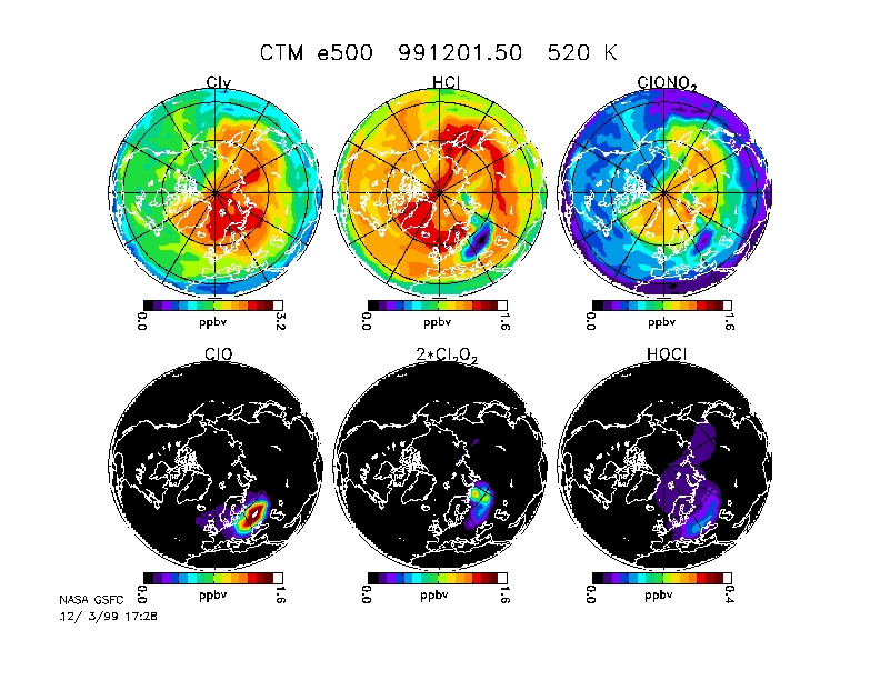
believe our analyses). Randy Kawa has used the GSFC chemical transport
model to show the effect of this event on the chlorine in the lower stratosphere
(click
here for the postscipt plot). The figure (valid for 12Z on 12/1)
shows high levels of ClO and low levels of HCl and ClONO2 as a result of
processing by PSCs (actually swollen sulfate aerosols). This air
will continue to move around the vortex and we're hoping the DC-8 can sample
it on Sunday.
ER-2 integration continues. The functional flight check was scrubbed
yesterday and that they'll try to fly the check flight today at 10 AM PST.
Integration is moving forward with a number of changes for a variety of
instruments. Steve Hipskind reports:
Saturday there will be a single shift from 7 am to 3 pm. The
functional check flight will be completed by noon. After the
ground has completed their post flight, we will continue working integration
issues as needed - FCAS, ACATS pump, ClONO2 fit check, MMS rack, ALIAS
cables to move power supply to rear tail cone.
Sunday there will also be a single shift from 7 am to 3 pm. We
will complete any outstanding integration issues, such as the fitting for
MASP to mount on the right superpod. We hope also begin the instrument
upload. Optimistically we will complete the instrument upload on Monday
concluding with the full-up electrical check. It looks like, realistically,
Tuesday will be the first opportunity for our operational check flight
(2 hour check flight with science instruments).
Wendy Dolci has sent out a detailed description of the Edward's AFB Operational
Readiness Inspection that will take place from 12/6-12/8. Wendy says,
"There will be simulations at various times of explosions, aircraft crashes,
hijackings, etc. so don't be surprised or overly alarmed if you see such
activities." Allright! The ER-2 instrument teams are ready
to leap into action.
Darryn Waugh has set up his SOLVE
forecasting web page using the Australian GASP analyses.
Friday 1999-12-03
Hurrah, Geoff Toon reported that the OMS-remote balloon payload was launched
this morning at 9:10 GMT from Esrange near Kiruna (Toon Flight # 476-N).
Geoff reports:
Just to let you all know that the JPL MkIV and SLS instruments
on the SOLVE/OMS remote gondola both had an excellent flight today. The
11.6 million cubic foot balloon (400,000 m3) was launched at 9:11 UT and
reached float altitude (4.6 mbar; 33 km) just over two hours later. The
MkIV instrument took spectra on ascent, and during the sunset. We anticipate
excellent quality profiles over the 4 to 31 km altitude range. Following
the sunset, the gondola was rotated 180 deg to allow the SLS instrument
to view, for an additional two hours, the same airmass that the MkIV instrument
had observed earlier.
The flight was terminated at 3:14 UT, after 4 hours at float, and landed
40 minutes later in Finland in the area SE of Sodankyla. There will be
no information as to the condition or exact location of the gondola until
tomorrow.
Many thanks to the Esrange and NSBF personel, who really pulled out
all of the stops to get the new crane rigged and gave us such a perfect
flight today.
Congratulations to the NSBF operations folks, Geoff Toon, Bob Stachnik,
and Bill Brune for doing a great job. See the NSBF
Kiruna page for updated information.
In other good news, the GSFC computer hardware shipment arrived at the
Arena Arctica in good condition. Hopefully Mark's clothes were in
the boxes. The emergency shipment of Ban roll-on has been cancelled.
The DC-8 is planning to fly again on Sunday (1999-12-05). Mark's
flight plan is to go northward towards Franz Josef land, turn westward
and overfly Ny-Alesund again, then turn soutward and overfly Iceland, turn
eastward to a point just north of Scotland, and then return directly to
Kiruna. The forecast shows fairly cold temperatures in the middle
of the vortex on Sunday above Franz Josef land. The DC-8 ought to
be able to get an intercomparison with the Ny-Alesund lidar and sondes,
and get into some of the air traffic corridors near Iceland. It also
appears that some of the air that passed through the ozone low of November
30 has swung around the vortex and will be passing between Iceland and
Kiruna on December 5. The GSFC chemical transport model shows that
HCl and ClONO2 was converted into ClO in this event.
The ER-2 is still not quite ready to do a functional check flight because
of some minor aircraft problems. We're hopeful that we can do an
electrical check on Sunday with a possible 2-hr instrument check flight
on Monday. Steve Hipskind reports that the C-141 is ready to go and
will takeoff at about 1:00 PM PST.
Thursday 1999-12-02
The DC-8 took off from Kiruna at 9:20 AM for an 8 hour flight. See
yesterday's note for a discussion of the flight plan. Mark Schoeberl's
report on the flight:
Takeoff at about 9:20 LT. All instrument operations nominal
except: Toohey
ClO and BrO and some of the TOTCAP
measurements.
Low clouds on takeoff. Lidars turned on shortly after takeoff.
Tropopause near 8 km. Stratospheric temperatures north of Kiruna
were near 190K between 22 and 30 km. Partial cloudiness over Ny Ålesund.
From DIAL
data - we were clearly inside the vortex over most of the flight.
After the Greenland waypoint, ASUR
reported problems and was unable to take any more ClO data.
We reached the POAM
measurement point on time and turned the aircraft to image the sun in the
CCD camera. Unfortunately the wing blocked the solar image, so we
vectored the aircraft northwest slightly to get the image. We then
turned south to get LASE
measurements
of the cloud field. The final maneuver should have well characterized
ozone in the area of the POAM overpass.
As we flew over the Norwegian mountains, we saw weak wave structure
in the lidar aerosol and temperature fields. Visual inspection of
the region south of the aircraft showed no evidence of PSCs - the NOGAPS
gravity wave prediction suggested that PSCs might form just south of
us where the jet hits the tip of
 John
Burris and the AROTEL lidar from GSFC looking forward in the NASA/DC-8.
Tom Mcgee is busy in the background.
John
Burris and the AROTEL lidar from GSFC looking forward in the NASA/DC-8.
Tom Mcgee is busy in the background.
Temperatures are cold at the 24 km level, and the vortex is nicely positioned
above Kiruna at altitudes from about 20 km on up. Forecasts show
that the vortex will continue to remain near Kiruna and the temperatures
at altitudes near 24 km will continue to be cold through Sunday.
This is just great for our measurements!
Geoff Toon reported that the launch attempt of the SOLVE/OMS remote
gondola from Esrange was abandoned at 06:00 AM due to unfavorable surface
winds. Float winds continue to look very good, so we will try again tomorrow
(Friday).
The ER-2 still requires work, so the actual integration will not begin
until Friday.
No news on the GSFC computer hardware shipment. Mark Schoeberl
is organizing a search party for the shipment and his clothes. All
of the teams with offices near Mark's have volunteered.
Wednesday 1999-12-01
The last month of 1999 begins!
Today's scheduled takeoff of the OMS remote balloon payload was scrubbed
this morning at 6:30 AM because of high surface winds. Geoff Toon
reports
that they'll try again tomorrow. These balloon launches are very
difficult because of the immense size of the balloon. The balloon
is so tall and large that it acts like a giant sail, so any wind of more
than a few mph can lead to some real scary moments as they try and launch,
possibly dragging the payload along the ground and destroying it.
Better luck tomorrow.
The DC-8
flight plan for tomorrow is to fly northwestward from Kiruna, and overfly
the Ny-Alesund station on Spitzbergen Island. Then continue westward
to Northern Greenland and turn south to make a coinsident observation with
the POAM satellite instrument at 64N and 4E. After proceeding a bit
soutward from that point, the DC-8 will come back up along the spine of
the Norwegian Alps to look at the predicted stratospheric mountain wave
activity.
 A
photo of polar stratospheric clouds observed out the window of the NASA
DC-8 upon as we circled Kiruna Sweden on November 30, 1999. The PSC's are
seen as white "cirrus" like clouds above the wing. These clouds were
well above the tropopause (~ 8 km) and the aircraft (~12 km) which was
in the lower stratosphere. The PSC's were predicted by mountain
wave forecasts for the region south of Kiruna. The DC-8 was transiting
to Kiruna for the first segment of the joint SOLVE - THESO-2000 mission
which is being run by the University of Colorado according to their recent
press release.
A
photo of polar stratospheric clouds observed out the window of the NASA
DC-8 upon as we circled Kiruna Sweden on November 30, 1999. The PSC's are
seen as white "cirrus" like clouds above the wing. These clouds were
well above the tropopause (~ 8 km) and the aircraft (~12 km) which was
in the lower stratosphere. The PSC's were predicted by mountain
wave forecasts for the region south of Kiruna. The DC-8 was transiting
to Kiruna for the first segment of the joint SOLVE - THESO-2000 mission
which is being run by the University of Colorado according to their recent
press release.
The lowest Northern Hemisphere ozone value ever
observed by TOMS was seen yesterday between Scotland and Norway over the
Norwegian Sea. The value of 165 DU was just lower than the previous
low value seen on 29 October 1985. As I remarked in yestterdays note,
the image of this low ozone feature can be seen at the TOMS
web-site.
Leslie Lait is still fuming about our computer shipment. Apparently
it is now enroute on a truck from Stockholm to Kiruna. Mark Schoeberl
is also unhappy, since he shipped his clothes to Kiruna with those computers.
 The
GSFC AROTEL lidar instrument is on the left of the image with co-PI Dr.
Tom Mcgee smiling for the camera. The photo was taken by Dr. Mark
Schoeberl during the transit flight of November 29, 1999. Astonishing that
someone was able to smile during a 10 hour flight from Dryden to Kiruna.
"Yesirree, this is WDC8 bringing you all the best heavy metal rock N'roll
from high above Kiruna, Sweden."
The
GSFC AROTEL lidar instrument is on the left of the image with co-PI Dr.
Tom Mcgee smiling for the camera. The photo was taken by Dr. Mark
Schoeberl during the transit flight of November 29, 1999. Astonishing that
someone was able to smile during a 10 hour flight from Dryden to Kiruna.
"Yesirree, this is WDC8 bringing you all the best heavy metal rock N'roll
from high above Kiruna, Sweden."
Tuesday 1999-11-30
The DC-8
took off from NASA/Dryden last
night at 4:45 PM PDT and arrived at Kiruna a bit after 11:30 AM (Sweden
time). Mark Schoeberl's synopsis of the flight:
Takeoff was at about 16:40 LT. All instrument operations
nominal. Intermittent clouds above the aircraft blocked the lidars
until we reached near 55N - clear thereafter. Aircraft was at 35Kft
during the first leg. An intrusion of stratospheric ozone with a
corresponding increase in NOy (PI: Kondo) was seen below the tropopause
at 3.2 hours into the flight - not too far away from the tropopause jump
associated with the polar jet. The aircraft ascended to 37Kft 3:45
hours into the flight, with a dramatic increase in ozone
(PI: B. Anderson) and NOy and decrease in CN
(PI: Brock) as we entered the stratosphere. Northward of 65 N
we began to underfly the vortex. As we approached Kiruna, temperatures
dropped slowly. AEROTEL
(PIs: Burris and McGee) and MTP
(PI: Mahoney) showed profiles with minimums of 190K (uncert ~1K); no
PSCs were observed by the lidars or visually. The ASUR
instrument detected a weak ClO signal from high altitudes (~40km) as we
approached Kiruna. The DC-8 overflew Kiruna and then spiraled in
for landing. It appears that the vortex we sampled was pretty much
unprocessed. As we descended, PSCs were clearly visible to the Project
Scientist to the south, in the approximate location of the coldest temperatures
and predicted mountain waves. The PSC looked like cirrus with wave
structure. Note that PSCs were also observed by POAM a few days ago.
Flight time was 10.5 hours due to the spiral descent.
The OMS remote
payload is scheduled for a 10 AM takeoff tomorrow. Since the
polar vortex is overhead at the moment, this should be a great flight for
seeing the partitioning of Cly and NOy in the early vortex.
The ER-2
integration
has begun, but re-wiring for the aircraft radios hasn't proceeded as smoothly
as we hoped. Current plans are that the aircraft will be re-assembled
and tested by Thursday, with instrument access to the aircraft by Thursday
evening (12/2).
The low ozone values observed near Iceland yesterday was one of the
lowest values observed in the Northern Hemisphere. Very low ozone
similar to these values were observed on 28 November 1996 and 29 October
1985. Images of these low ozone values can be found at the TOMS
web-site.
The GSFC shipment of computer hardware remains hung-up in customs in
Stockholm. Leslie Lait relates, "Right now, we are relying on the
laptops to access the web pages back home. We have no local disk
space here, so we are unable to run the flight planner. So
we are pretty much hosed unless that shipment comes in today."
The gravity wave forecasting models are now up and running. Forecasts
can be found on the University
of Leeds web-site.
Monday 1999-11-29
Many of the DC-8 folks took a break for Thanksgiving, and returned to NASA/Dryden
following the Thanksgiving weekend (11/27) to prepare for tonight's (Monday,
29 November) transit to Kiruna, Sweden. Mark
Schoeberl (DC-8 project scientist) reports that all of the instruments
are working and ready for the flight. The DC-8 will leave NASA/Dryden at
about 4:30 PM local time, and reach Kiruna at about 11 AM (Swedish time).
It really looks like the transit will be great, since the meteorological
forecasts show the DC-8's direct route to Kiruna cutting right across
the
polar
vortex!
We've been waiting for a launch of the OMS remote payload, but apparently
a mishap with the launch crane has caused a delay of a few days.
The ER-2 instrument teams will begin to arrive at NASA/Dryden this week
(11/29-12/3) to begin instrument integration. The GSFC forecasting group
(Leslie
Lait, David
Gent, and Andrea Ledvina) arrived in Kiruna over the weekend of 11/27-29.
Unfortunately, none of the GSFC computer hardware was at Kiruna when they
arrived. However, Leslie and David carried lap-top computers to Kiruna
on their flights.
Temperatures
have been steadily cooling in the northern polar region. So far our
conventional observations of the northern region show that it hasn't gotten
cold enough to form polar
stratospheric clouds (PSCs) down at 20 km, but that it is cold enough
at 30 hPa (24 km) to form PSCs. Rich
Bevilacqua (POAM instrument PI) reported today that the POAM nstrument
detected a PSC at 24 km near 65N, 36E (just east of Kiruna in Russia).
Recall that as air flows through PSCs, the air's chemical makeup is dramatically
altered, converting chlorine compounds into forms that lead to ozone loss.
Total ozone amounts
in the North Atlantic have been very low over the last few days. These
ozone lows result from large scale weather systems moving northward from
the mid-latitudes. In fact, Rich
McPeters reported that the total ozone value near Iceland was down
to 185 DU!
SOLVE Links
General
Forecasting
Stratospheric meteorology
Last Updated: 1999-11-23
 Author:
Dr.
Paul A. Newman
(NASA/GSFC, Code 916) (newman@notus.gsfc.nasa.gov)
Author:
Dr.
Paul A. Newman
(NASA/GSFC, Code 916) (newman@notus.gsfc.nasa.gov)
Web Curator: Dr. Leslie R. Lait (Raytheon ITSS) (lrlait@ertel.gsfc.nasa.gov)
Responsible NASA organization/official: Dr. Paul A. Newman, Atmospheric
Chemistry and Dynamics Branch