Inter-comparisons of the V8 SBUV instruments (Nimbus 7, NOAA 9, 11, and 16): Time, Altitude and Latitude dependency
|
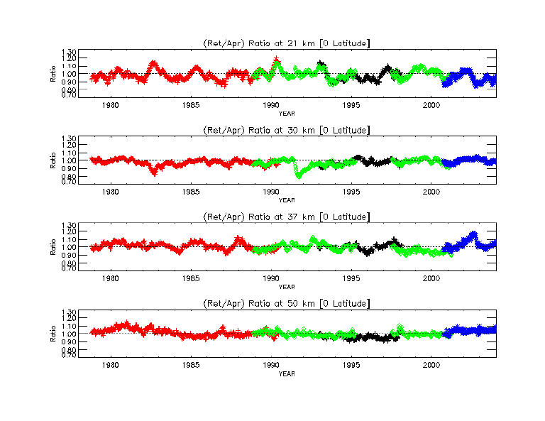
Weekly zonal mean data sets created in 5-degree latitude intervals are used to
make time series of the ratios of the retrieved layer ozone to the a priori layer ozone.
The figure below shows the ratio time series at four selected altitudes (21 km, 30 km, 37 km, and 50 km) in
the Equator latitudinal zone. The different instruments are distinguished by color
(Red: Nimbus-7, Black: NOAA-9, Green: NOAA-11, and Blue: NOAA-16).
The midpoint pressures of the V8 atmospheric layers are converted to a logarithm-scale standard
altitude in kilometers by using a scale height of 7 km. The V8 a priori has an annual cycle and annual mean
that vary with altitude (in approximately 5-km layers) and latitude (10-degree bands), but has no inter-annual
or long-term variability. Therefore, these ratio plots show both V8 algorithm retrieval
performance as well as possible instrument problems. [Click on any of the figures in this document to see a full size version.]
|
 Equator Ratio (Retrieved/Apriori) Time Series
|
|
At the Equator, a Quasi-Biennial Oscillation (QBO) cycles can be seen in
the lower layers, and volcanic effects in 1982 and 1991 can be
seen in the 30 km layer. In general, most of instruments
compare well during the overlapped time periods over all latitudes --
within ± 8 % except for early years of NOAA-9 (pre 1993 not shown on these
plots, but included on the DVD) due to the unresolved instrument performance
issues. The agreement among instruments has latitude and
altitude-dependencies, particularly in the southern hemisphere.
The APPENDIX contains ratio time series plots at other latitudes. Contour plots showing the average mixing ratio differences in pairs of instruments during their overlap periods are shown in the Appendix. |
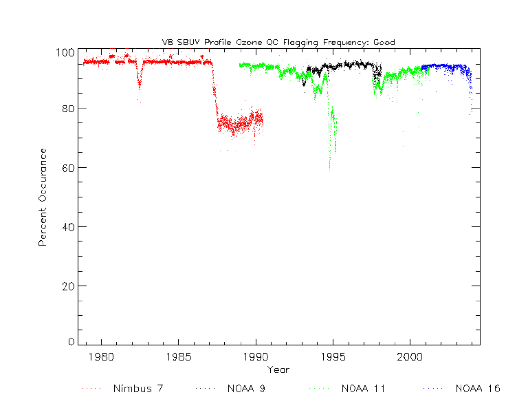
Profile Quality Checking : the Percent Occurrence of Good Profiles
| The figure below shows the percentage of profiles with profile error codes of 0 (good retrieval) or 1 (solar zenith angle greater than 84 degree) for each day. The significant decrease in Nimbus-7 occurs during the non-synchronization period. The decreases in NOAA-9 and NOAA-11 are due to grating drive problems and all of the NOAA-11 1995 data are at high solar zenith angles. |
|
|
 Profile Ozone QC Flagging Plot
V8 SBUV Profile Total Ozone Comparison with Dobson Stations in the Northern Hemisphere
|
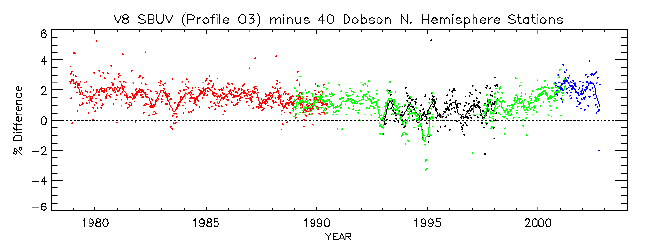
The profile total ozone is more reliable with fewer
wavelength-dependent errors than conventional TOMS-like total ozone products.
The matched-up V8 SBUV profile total ozone data are averaged on a weekly
basis and compared with ground-based Dobson total ozone measurements from 40
stations in the northern hemisphere. The data smoothed with 15-point running
averages, are shown as solid lines for each instrument. The V8 SBUV profile
total ozone is up to 2 % (~ 6 D.U) higher than Dobson total ozone,
but has no significant long-term trends.
|
 V8 SBUV Profile - Dobson Total Ozone
Seasonal Variations of Layer Ozone over Lauder, New Zealand
|
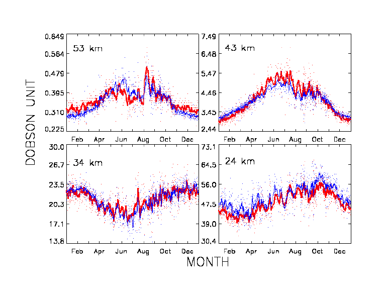
The figure below shows seasonal variations for
the NOAA-11 SBUV/2 data over Lauder, New Zealand (45oS, 170oE)
and corresponding measurements from a ground-based microwave instrument at
four altitudes. All available matched-up samples (n=872) for the NOAA-11 time
period are used to make these plots. Thick red lines are microwave data smoothed
with 7-point running averages. Blue lines are V8 SBUV data, also smoothed
with 7-point running averages. A dynamic transport from ozone rich air
in the tropics builds up the maximum ozone in late winter and early spring in the
lower stratosphere at 24 km. A typical annual cycle (maximum in summer and
minimum in winter) is shown in the middle stratosphere at 34 km. In the upper
stratosphere above 43 km, a winter (June, July, August) ozone maximum is
dominant due to the reduced ozone destruction rate. The V8 SBUV data agree
well with the microwave data in terms of both offset and seasonal cycle
variation. This result is consistent with SAGE II, LIDAR, and ozonesonde
comparison results presented in Brinksma et al. [2002].
|
|
|
 Seasonal variations of layer ozone at four altitudes
Time Series of Microwave to V8 SBUV Layer Ozone over Mauna Loa
|
The figure below shows the time series analysis of the ratio
of microwave to V8 SBUV layer ozone over Mauna Loa (20oN, 156oW). The three solid
lines are the linear regression fits for the time periods of NOAA-9 (Jul.
1995 to Jul. 1997), NOAA-11 (Jul. 1997 to March 2001), and NOAA-16 (Oct. 2000
to Nov. 2002), respectively, at four altitudes. Mauna Loa is a good site to
do intercomparisons because it is not only the primary Network for the
Detection of Stratospheric Change (NDSC)
station for the tropics and subtropics, but also has low ozone variability
that minimizes the uncertainty caused by differences in the same air volumes
measured by different instrument [McPeters et al., 1999]. This plot
does not show any significant trend for this short-term period (7 and 1/2
years), and also demonstrates a good agreement between SBUV instruments in
the overlaps except in NOAA-9 time period coincidences at 37 km.
Nevertheless, the linear regression fits have no significant slope larger
than the standard deviation (numbers not shown here) as Tsou et al.
[2000] described.
|
|
|
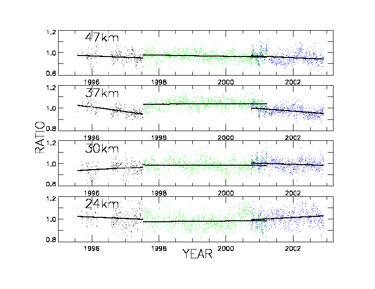 Time Series Analysis of the Ratio (Microwave/V8SBUV)
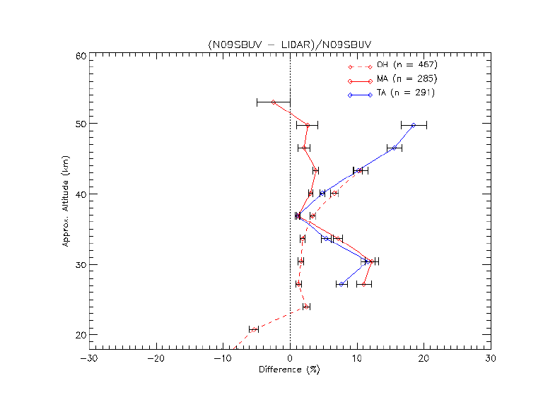
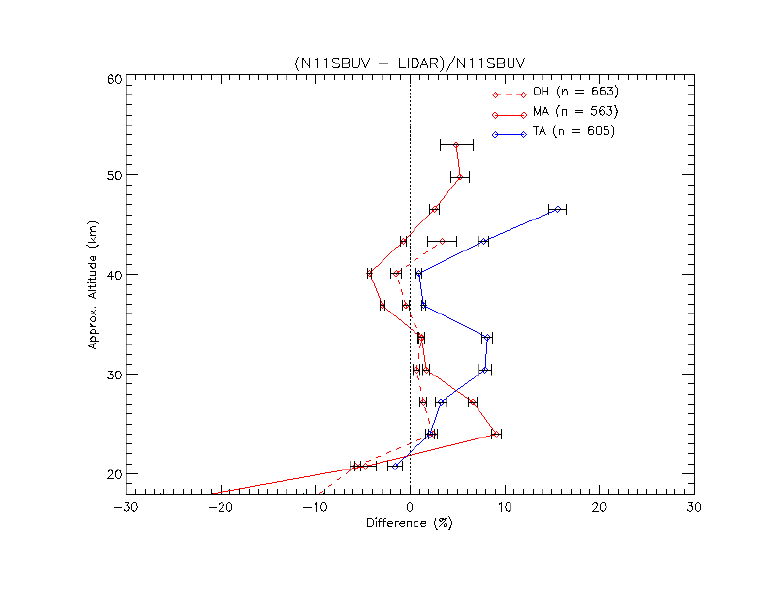
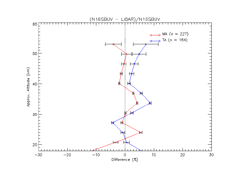
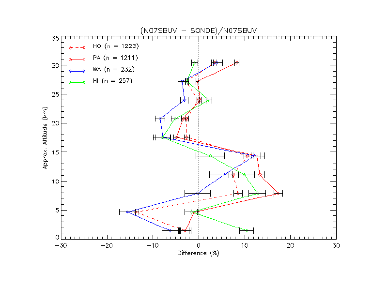
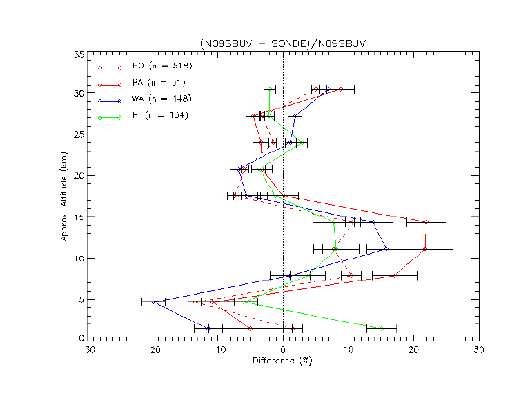
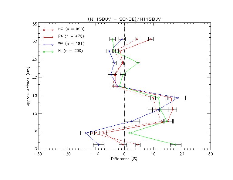
Mean Profile Differences (%) between V8 SBUV and Ground Measurements (Microwave, Lidar and Sonde)
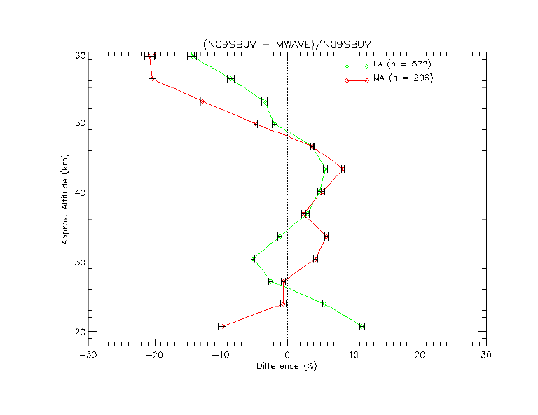
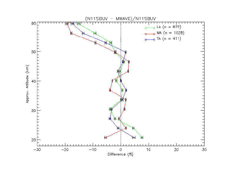
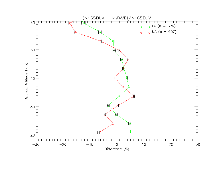
|
The V8 SBUV profile ozone data are validated using ground-based data (microwave, LIDAR, and ozonesonde) with independent calibrations and derivation methods at various locations around globe. Microwave and LIDAR data are available from NDSC . Ozonesonde data are archived in World Ozone and Ultraviolet Radiation Data Center(WOUDC). The first two initials of the names of stations are used as legends on the plots as follows; Microwave: LA(Lauder), MA(Mauna Loa), TA(Table Mt).
|
References
|
Brinksma, E. J., J. Ajtic, J. B. Bergwerff, G.E. Bodeker, I. S. Boyd, J. F. de Haan, W. Hogervorst, J. W. Hovenier, and D.P. J. Swart, Five years of observations of ozone profiles over Lauder, New Zealand, J. Geophys. Res., 107(D14), 10.1029/2001 JD000737, 2002.
Leblanc, T., and I. S. McDermid, Stratospheric ozone climatology from lidar measurements at Table Mountain (34.4N, 117.7W) and Mauna Loa (19.5N, 155.6W), J. Geophys. Res., 105, 14,613-14,623, 2000. McPeters, R. D., D. J. Hoffman, M. Clark, L. Flynn, L. Froidevaux, M. Gross, B. Johnson, G. Koenig, X. Liu, S. McDermid, T. McGee, F. Mucray, M. J. Newchurch, S. Oltmans, A. Parrish, R.Schnell, U. Singh, . J. Tsou, T. Walsh, and J. M. Zawodny, Results from the 1995 stratospheric ozone profile intercomparison at Mauna Loa, J. Geophys. Res., 104, 30,505-30,514, 1999. Tsou, J. J., B. J. Conner, A. Parrish, R. B. Pierce, I. S. Boyd, G. E. Bodecker, W. P. Chu, J. M. Russell III, D. P. J. Swart, and T. J. McGee, NDSC millimeter wave ozone observations at Lauder, New Zealand, 1992-1998: Improved methodology, validation, and variation study, J. Geophys. Res., 105, 24,263-24,281, 2000.
|