
![[menu bar image map]](/menubar.gif)
An airborne lidar to measure methane, water vapor, and temperature on board NASA's flying laboratory, the DC-8, has been developed at Goddard Space Flight Center. Methane and water are measured using Raman (inelastic) scattering, while temperatures are determined from both Rayleigh (elastic) scattering and nitrogen Raman. Methane's long stratospheric lifetime (approximately a decade) makes it an ideal conserved tracer to track the motions of streamers or filametns of air as they peel off the polar vortex. Temperature measurements allow a calculation of the quasi-conserved quantity, potential temperature, which is useful in following the motions of large air parcels. The water measurement allows stratospheric water transport across the subtropical boundary to be studied.
The Airborne Raman Lidar (ARL) consists of several basic components. The light source is a XeF (oscillator/amplifier) excimer with an AVERAGE output at 351 nm of 60 watts (300 mj/pulse at 200 Hz). A newtonian telescope with a 40 cm primary collects the return signal which is detected by six photomultiplier tubes (PMTs) operating in the photon counting mode. The PMT outputs are used by a computer to generate data profiles. Methane and water are measured from the platform altitude (about 12 km) to approximately 22 km (all altitudes are geometric). Temperatures are calculated from 2 km above the platform to approximately 48 km, although the data allow temperature determinations above 70 km. Vertical resolutions are 300 meters for all measurements; temperature files are generated using data acquired over 2.5 minutes, methane and water use 20-minute averages.
The methane lidar flew a series of test flights in April 1994, and successfully participated in the TOTE/VOTE Mission in December 1995 through February 1996.
 Figure 1.Temperature profiles along the flight track of the NASA DC-8
during the flight of 11 December 1995. Contours of temperature from meteorological
analyses are overlaid. (The full image is 23 Kb.)
Figure 1.Temperature profiles along the flight track of the NASA DC-8
during the flight of 11 December 1995. Contours of temperature from meteorological
analyses are overlaid. (The full image is 23 Kb.)
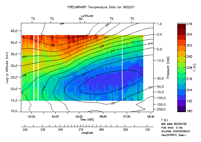 Figure 2.Temperature profiles along the flight track of the NASA
DC-8
during the flight of 1 February 1996. Contours of temperature from meteorological
analyses are overlaid. (The full image is 20 Kb.)
Figure 2.Temperature profiles along the flight track of the NASA
DC-8
during the flight of 1 February 1996. Contours of temperature from meteorological
analyses are overlaid. (The full image is 20 Kb.)
The ARL team consists of Bill Heaps, John Burris, Walt Hoegy, Leslie Lait, and Don Silbert. For an introduction to the instrument, see the December 20, 1996, issue of Applied Optics, pages 7128-7135.
![]() Back to the Ground-based and Airborne Instruments page
Back to the Ground-based and Airborne Instruments page
Last Updated: 1997-01-14
Web Curator: Leslie R. Lait (Hughes STX) (lrlait@ertel.gsfc.nasa.gov)
Responsible NASA organization/official: Dr. P. K. Bhartia, Atmospheric Chemistry and Dynamics Branch/Head