SBUV (Version 8.7) INSTRUMENT SUMMARY
The Solar Backscatter Ultraviolet (SBUV) observing system consists of a series of instruments that measure the ozone profile from the ground to the top of the atmosphere. All data have been retrieved using the Version 8.7 algorithm (released Fall 2021). Measurements are reported as partial column ozone amounts in defined pressure layers. The total column ozone is the sum of the partial column amounts. Three versions of the SBUV instrument are used in the series, but the fundamental measurement technique is the same over the evolution of the instrument from BUV to SBUV/2. A next generation instrument, the Ozone Mapping Profiler Suite (OMPS) Nadir Profiler, continues the SBUV series.
We use the following rules to construct v2 Release 1 of the Merged Ozone Data Set (New Rules Highlighted)
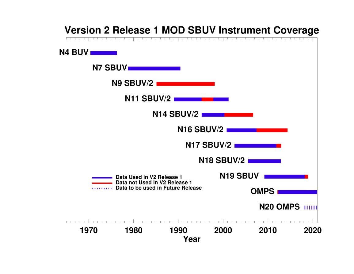
- Include only measurements taken when the Local Equator Crossing Time (LECT) of the orbit is between 8am and 4pm, with the exception of N11 pre-terminator data to avoid gaps in the record. Additionally, N14 and N16 data taken after the orbit passed through the terminator are not included in this version.
- To remove diurnal differences due to different satellite measurement times, measurements from each instrument (except OMPS NP) are adjusted post-retrieval to an equivalent measurement time of 1:30pm using a model-based diurnal ozone climatology.
- Do not include N9 data, except to fill gaps in the TOTAL OZONE in 1994-1995 as N11 progressed towards the terminator and lost latitudinal coverage.
- Filter Profile MOD after the eruptions of the El Chichon and Mt. Pinatubo volcanoes.
- Use a simple average to combine data when multiple instruments are operating to construct a single consistent data set. No additional offsets are applied to indivdiual data sets.
Table of Measurements used in v2 Release 1 MOD
| Instrument | Data Links* | Data Start | Data End | Data Usage/Comments |
|---|---|---|---|---|
| Nimbus 4 BUV |
5° MZM (Text) 5° MZM (HDF) |
May, 1970 | April, 1976 | In mid-1972 partial failure of the N4 solar power array forced limitations on
instrument operating time, resulting in intermittent data coverage, which became
increasingly sparse with time. Zonal mean data are limited after mid-1972 but
zones with sufficient coverage are included in the data set. All N4 BUV data are included for historical reference, but these data should not be used for trend analysis. |
| Nimbus 7 SBUV |
5° MZM (Text) 5° MZM (HDF) |
November, 1978 | May, 1990 | N7 SBUV data after February 1987 are affected by chopper
wheel synchronization errors. This caused an
increase in measurement noise, but monthly zonal mean values
are minimally effected. All N7 SBUV data are used. |
| NOAA 9 SBUV/2 |
5° MZM (Text) 5° MZM (HDF) |
February, 1985 | January, 1998 | N9 SBUV/2 profile data are of poorer quality, though the total
column ozone compare well with other instruments. Therefore N9
total ozone are used, but only to fill gaps in the MOD total ozone
data set caused by decreased N11 latitude coverage in 1994-1995. Power problems
after June 1997 seriously degraded the N9 longitudinal
coverage. The N9 orbit drifted throughout its operation.
No N9 SBUV/2 profile data are used. N9 SBUV/2 total column data are used only to fill gaps in 1994-1995. |
| NOAA 11 SBUV/2 |
5° MZM (Text) 5° MZM (HDF) |
January, 1989 | March, 2001 | N11 SBUV/2 suffered problems with the instrument grating drive
beginning in late 1993. These errors increased in the late 1990s,
but soft-calibration techniques are used to correct the data. The
N11 orbit drifted in time, such that the satellite was in a
terminator orbit from April 1995 - July 1997. We use all data before the orbit
reached terminator, and data after the LECT passed 8am.
Apr 1995 - Sep 1997 N11 SBUV/2 data are not used. |
| NOAA 14 SBUV/2 |
5° MZM (Text) 5° MZM (HDF) |
March, 1995 | September, 2006 |
N14 SBUV/2 developed grating drive errors several months
after launch, and the errors became progressively worse with
time. In addition, the cloud cover radiometer failed
directly after launch. The grating drive control was
reprogrammed in June 1998 to compensate for grating drive
issues as well as for the CCR failure. The N14 satellite was
in a terminator orbit from May 2002 - August 2003 and outside
the 8am-4pm LECT range from May 2000 - June 2004.
N14 SBUV/2 Data after May 2000 are not used. |
| NOAA 16 SBUV/2 |
5° MZM (Text) 5° MZM (HDF) |
October, 2000 | May, 2014 | N16 SBUV/2 periodically experiences electronic
interference in measurements that are used in the derivation
of total ozone. However, total ozone calculated as the sum
of the profile total, as is done in the V8.7 SBUV MOD, is not
sensitive to this error. The N16 satellite began drifting in
early 2004, was in a terminator orbit from May 2009 - March 2010, and was outside the
8am-4pm LECT range from July 2007 - November 2011. The N16 instrument failed in early June, 2014.
N16 SBUV/2 Data after July 2007 are not used . |
| NOAA 17 SBUV/2 |
5° MZM (Text) 5° MZM (HDF) |
August, 2002 | March, 2013 | The N17 satellite was launched into a morning local solar time orbit, and
began drifting toward the terminator (earlier in time) in late 2007. In October 2011 N17
passed the 8am LECT orbit threshold, and entered into a terminator orbit in February 2013.
N17 was decommisioned in April, 2013.
No N17 SBUV/2 data are used after September 2011. |
| NOAA 18 SBUV/2 |
5° MZM (Text) 5° MZM (HDF) |
July, 2005 | November, 2012 | The N18 instrument chopper wheel ceased operating in December 2012. All N18 SBUV/2 data are used. |
| NOAA 19 SBUV/2 |
5° MZM (Text) 5° MZM (HDF) |
March, 2009 | Operational | NOAA-19 was launched in March 2009, but has now drifted beyond the 4pm LECT threshold. No N19 SBUV/2 data are used after March 2018. |
| Suomi NPP OMPS |
5° MZM (Text) 5° MZM (HDF) |
December, 2011 | Operational | OMPS is the next generation
nadir-viewing BUV instrument used to continue the MOD time
series. OMPS Nadir Profiler V2.8 data are now included in MOD. The V2.8 data have been inter-calibrated to
the SBUV series based on overlap comparisons with N19. All OMPS NP Data after April 2012 are used. |
| SBUV Satellite Data Coverage shows the time period during which each instrument was collecting reliable profile ozone measurements (blue line segments in figure). When data from all the instruments are included, the coverage is nearly continuous from late 1978 to the present. | ||||
*The 5° MZM files for each instrument are the base data sets for the Merged Data Set. The MZM files are available in a simple text format and in HDF format. HDF files contain ancillary data including Smoothing Error, Averaging Kernels, Averaging Statistics, A Priori, Standard Deviations and more.
Additional V8.7 SBUV Data Links
Several data products are available based on the Version 8.7 SBUV data. Users may follow these links to access SBUV data for specific purposes.
- 5° Monthly Zonal Mean README File [Informative document covering individual instrument issues and contents of full 5° Monthly Zonal Means files.]
- Daily Overpass Profiles at Specified Stations [Daily overpass files from all instruments aggregated into single file.]
- MOD v2 Release 1 daily overpass data [Daily overpass files are merged according to the MOD v2 Release 1 data specifications.]
